Bushnell 36-2005 Brochure
Bushnell 36-2005 Manual
 |
View all Bushnell 36-2005 manuals
Add to My Manuals
Save this manual to your list of manuals |
Bushnell 36-2005 manual content summary:
- Bushnell 36-2005 | Brochure - Page 1
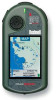
all your photo and map downloads. Log on to learn more about advanced GPS technology made amazingly simple. Introducing Bushnell ONIX200. The first handheld GPS to support satellite photography. Bushnell-exclusive TruView™ technology displays satellite and aerial photos of your surroundings, so you
-
 1
1
 |
 |

Introducing Bushnell ONIX200. The first handheld GPS to support
satellite photography.
Bushnell-exclusive TruView
™
technology displays
satellite and aerial photos of your surroundings, so you navigate by what you see
– around you and on your GPS. Navigation has never been this fast and efficient,
thanks in part to our exclusive screen-layering feature and the ultra-simple interface.
The world’s most advanced handheld navigation system just made all your paper
maps and aerials obsolete. Along with every other GPS. For more info, visit
www.bushnellgps.com
.
www.bushnell.com
Exclusive TruView
™
navigation displays
satellite and aerial photos.
You can now navigate by
visually referencing your
surroundings with what’s
pictured in your palm.
The only GPS
with screen layering
.
The ONIX200 layers a satellite
image, aerial photo or topo
map, and all navigational aids in
perfect harmony on a single screen.
www.bushnellgps.com
One source for all your photo and
map downloads. Log on to learn
more about advanced GPS
technology made amazingly simple.
©2007 BOP
™
®
Compass
Trail and
waypoints
Compass, trail and
waypoints layered
over satellite photo