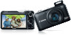
Canon PowerShot SX230 HS PowerShot SX230 HS / SX220 HS Camera User Guide - Page 102
Using the GPS Function
 |
View all Canon PowerShot SX230 HS manuals
Add to My Manuals
Save this manual to your list of manuals |
Page 102 highlights
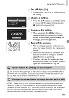
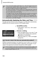
Using the GPS Function SX230 HS This function uses signals received from multiple GPS satellites to record location information (latitude, longitude, elevation) in still images and movies. The location information data can also be recorded separately from images and movies. Additionally, this function can be used to automatically update the camera's clock. Before using the GPS function, make sure to correctly set the date/time and your home time zone (p. 19) beforehand. GPS stands for "Global Positioning System". Please keep the following things in mind when using the GPS function. • In certain countries and regions, the use of GPS may be restricted. Therefore, be sure to use GPS in accordance with the laws and regulations of your country or region. Be particularly careful when traveling outside your home country. • Exercise caution when using this function in places that restrict the use of electronic devices, as the camera receives signals from GPS satellites. • The camera's positioning information recorded in images and movies with the GPS function may contain information that can be used to determine your physical location. Be sure to take adequate precautions when transferring images containing camera positioning data and GPS log files to others, or when uploading these files to the internet where they can be viewed by numerous people. • Since it may not be possible to receive GPS satellite signals correctly in the following situations, the camera's positioning data may not be recorded or the recorded position may differ from the actual position. When indoors, under ground, under water (using separately-sold waterproof case) (p. 39), in tunnels or forests, near buildings or valleys, near high-voltage power lines or mobile phones that use a frequency of 1.5 GHz. Since the position of GPS satellites changes over time, the camera's positioning data may not be recorded or the recorded position may differ from the actual position even in situations other than those mentioned above. • It may take some time to receive a signal from GPS satellites after switching the battery, or if the GPS function has not been used for a long time. 102
-
 1
1 -
2
-
3
-
4
-
5
-
6
-
7
-
8
-
9
-
10
-
11
-
12
-
13
-
14
-
15
-
16
-
17
-
18
-
19
-
20
-
21
-
22
-
23
-
24
-
25
-
26
-
27
-
28
-
29
-
30
-
31
-
32
-
33
-
34
-
35
-
36
-
37
-
38
-
39
-
40
-
41
-
42
-
43
-
44
-
45
-
46
-
47
-
48
-
49
-
50
-
51
-
52
-
53
-
54
-
55
-
56
-
57
-
58
-
59
-
60
-
61
-
62
-
63
-
64
-
65
-
66
-
67
-
68
-
69
-
70
-
71
-
72
-
73
-
74
-
75
-
76
-
77
-
78
-
79
-
80
-
81
-
82
-
83
-
84
-
85
-
86
-
87
-
88
-
89
-
90
-
91
-
92
-
93
-
94
-
95
-
96
-
 97
97 -
 98
98 -
 99
99 -
 100
100 -
 101
101 -
 102
102 -
 103
103 -
 104
104 -
 105
105 -
 106
106 -
 107
107 -
108
-
109
-
110
-
111
-
112
-
113
-
114
-
115
-
116
-
117
-
118
-
119
-
120
-
121
-
122
-
123
-
124
-
125
-
126
-
127
-
128
-
129
-
130
-
131
-
132
-
133
-
134
-
135
-
136
-
137
-
138
-
139
-
140
-
141
-
142
-
143
-
144
-
145
-
146
-
147
-
148
-
149
-
150
-
151
-
152
-
153
-
154
-
155
-
156
-
157
-
158
-
159
-
160
-
161
-
162
-
163
-
164
-
165
-
166
-
167
-
168
-
169
-
170
-
171
-
172
-
173
-
174
-
175
-
176
-
177
-
178
-
179
-
180
-
181
-
182
-
183
-
184
-
185
-
186
-
187
-
188
-
189
-
190
-
191
-
192
-
193
-
194
-
195
-
196
-
197
-
198
-
199
-
200
-
201
-
202
-
203
-
204
-
205
-
206
-
207
-
208
-
209
-
210
-
211
-
212
 |
 |