Canon PowerShot SX260 HS PowerShot SX260 HS / SX240 HS Camera User Guide - Page 44
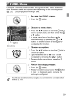
How to Carry the Camera When Using the Logger, Function
 |
View all Canon PowerShot SX260 HS manuals
Add to My Manuals
Save this manual to your list of manuals |
Page 44 highlights
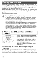
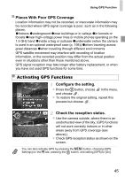
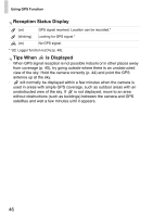
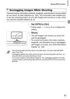
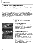
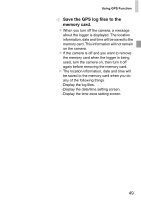
Using GPS Function Camera location information (latitude, longitude, and elevation) based on acquired GPS signals can be added to the still images and movies you shoot, or this information can be logged separately. In addition to geotagging, the camera clock can be updated automatically. Before using GPS functions, make sure the date, time, and local time zone on the camera are set correctly, as described in "Setting the Date and Time" (p. 17). GPS: Global Positioning System When using GPS functions, keep the following points in mind. • In certain countries and regions, the use of GPS may be restricted. Therefore, be sure to use GPS in accordance with the laws and regulations of your country or region. Be particularly careful when traveling outside your home country. • Be careful about using GPS features where the operation of electronic devices is restricted, because the camera will receive GPS signals. • Others may be able to locate or identify you by using location data in your geotagged still images or movies. Be careful when sharing these images or GPS log files with others, as when posting images online where many others can view them. Where to Use GPS, and How to Hold the Camera GPS Antenna z Use the camera outside, where there is an unobstructed view of the sky. (GPS functions will not work correctly indoors or in other areas away from GPS coverage (p. 45).) z Hold the camera correctly, as shown, for easier GPS signal reception. z Keep your fingers or other objects off the GPS antenna. How to Carry the Camera When Using the Logger Function For better GPS signal reception, try to keep the GPS antenna pointing up, toward the sky. When carrying the camera in a bag, put it in the bag with the GPS antenna pointing up, and try to put the camera in an outer section of bag. 44
-
 1
1 -
2
-
3
-
4
-
5
-
6
-
7
-
8
-
9
-
10
-
11
-
12
-
13
-
14
-
15
-
16
-
17
-
18
-
19
-
20
-
21
-
22
-
23
-
24
-
25
-
26
-
27
-
28
-
29
-
30
-
31
-
32
-
33
-
34
-
35
-
36
-
37
-
38
-
 39
39 -
 40
40 -
 41
41 -
 42
42 -
 43
43 -
 44
44 -
 45
45 -
 46
46 -
 47
47 -
 48
48 -
 49
49 -
50
-
51
-
52
-
53
-
54
-
55
-
56
-
57
-
58
-
59
-
60
-
61
-
62
-
63
-
64
-
65
-
66
-
67
-
68
-
69
-
70
-
71
-
72
-
73
-
74
-
75
-
76
-
77
-
78
-
79
-
80
-
81
-
82
-
83
-
84
-
85
-
86
-
87
-
88
-
89
-
90
-
91
-
92
-
93
-
94
-
95
-
96
-
97
-
98
-
99
-
100
-
101
-
102
-
103
-
104
-
105
-
106
-
107
-
108
-
109
-
110
-
111
-
112
-
113
-
114
-
115
-
116
-
117
-
118
-
119
-
120
-
121
-
122
-
123
-
124
-
125
-
126
-
127
-
128
-
129
-
130
-
131
-
132
-
133
-
134
-
135
-
136
-
137
-
138
-
139
-
140
-
141
-
142
-
143
-
144
-
145
-
146
-
147
-
148
-
149
-
150
-
151
-
152
-
153
-
154
-
155
-
156
-
157
-
158
-
159
-
160
-
161
-
162
-
163
-
164
-
165
-
166
-
167
-
168
-
169
-
170
-
171
-
172
-
173
-
174
-
175
-
176
-
177
-
178
-
179
-
180
-
181
-
182
-
183
-
184
-
185
-
186
-
187
-
188
-
189
-
190
-
191
-
192
-
193
-
194
-
195
-
196
-
197
-
198
-
199
-
200
-
201
-
202
-
203
-
204
-
205
-
206
-
207
-
208
-
209
-
210
-
211
-
212
-
213
-
214
-
215
-
216
-
217
-
218
-
219
-
220
-
221
-
222
-
223
-
224
-
225
-
226
-
227
-
228
-
229
-
230
-
231
-
232
-
233
-
234
-
235
-
236
-
237
-
238
-
239
-
240
-
241
-
242
-
243
-
244
-
245
-
246
 |
 |