Garmin 010-10680-50 BlueChart g2 Vision User's Guide
Garmin 010-10680-50 - MapSource City Navigator NT Manual
 |
UPC - 753759066451
View all Garmin 010-10680-50 manuals
Add to My Manuals
Save this manual to your list of manuals |
Garmin 010-10680-50 manual content summary:
- Garmin 010-10680-50 | BlueChart g2 Vision User's Guide - Page 1
data. This guide provides an overview of some of these features. For more detailed information, see the owner's manual for your Garmin marine GPS zoom in or out. Marine Services and Points of Interest (POI) In many areas, BlueChart g2 Vision maps feature Marine Services and other land-based points - Garmin 010-10680-50 | BlueChart g2 Vision User's Guide - Page 2
of product updates or information about new products. Have the ID code of your preprogrammed BlueChart g2 Vision SD card handy, connect to Garmin's Web site at www.garmin.com/registration and follow the instructions. To read the ID code on a BlueChart g2 Vision SD Card: BlueChart g2 Vision SD cards
-
 1
1 -
 2
2
 |
 |
BlueChart g2 Vision
Preprogrammed BlueChart g2 Vision SD cards allow you to get the most out of your Garmin marine
GPS unit. In addition to detailed marine charting, BlueChart g2 Vision features:
•
Mariner’s Eye 3D
—a bird’s eye view from above and behind the boat, for a more visual
navigation aid
.
•
Fish Eye 3D
—an underwater view that visually represents the sea floor according to the
chart’s information.
•
Fishing Chart
—
view the chart without navigational data, leaving only the bottom contours
and depth soundings.
•
High Resolution Satellite Imagery
—high resolution satellite images are provided for a
realistic view of the land and water on the Navigation Chart.
•
Aerial Photos
—you can view marinas and other navigationally significant aerial photos to
help you visualize your surroundings.
•
Detailed Roads and POI data
—you can search for and view roads, restaurants, attractions,
and other points of interest (POIs) along the shore.
•
Tide and Current Data
—you can access tide and current station information.
•
Auto Guidance
—you can use the Auto Guidance technology suggest the best passage
based on the chart data.
This guide provides an overview of some of these features. For more detailed information, see the
owner’s manual for your Garmin marine GPS unit. Not all of these features are available on every card.
Using the SD card
You can insert or remove a BlueChart g2 Vision SD card while your Garmin GPS
unit is on or off.
Insert the SD card, label up, into the open SD card slot on your
Garmin GPS unit and press in until it clicks.
Press in again to eject the SD card.
BlueChart g2 Vision SD cards are not waterproof. When you are not using the
card, keep it in the original packaging for safekeeping and store it away from
exposure to sun and rain. BlueChart g2 Vision SD cards are susceptible to damage from static
electricity. In low humidity environments, you should ground yourself on a large metal object
before handling the card.
NOTE:
BlueChart g2 Vision data cannot be transferred from the SD card to your PC for backup or
viewing purposes. The SD card can only be used on BlueChart g2 Vision compatible Garmin GPS units.
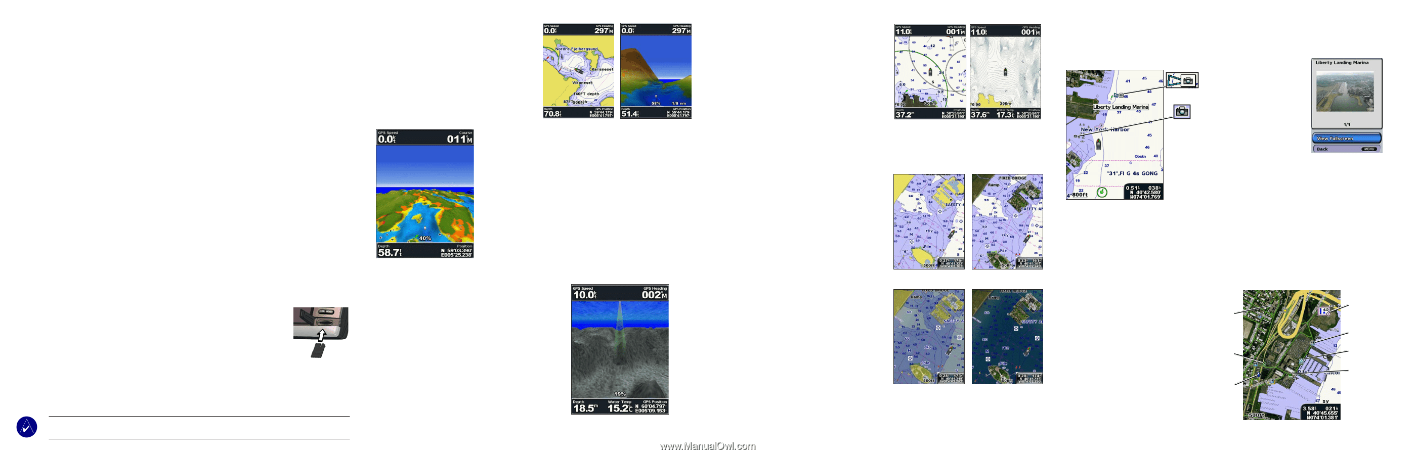
Mariner’s Eye 3D
Mariner’s Eye 3D
provides a bird’s eye view
from above and behind the boat (according to your
course), and provides a visual navigation aid. This
view is helpful when navigating tricky shoals,
reefs, bridges, or channels.
Mariner’s Eye 3D
is
beneficial when trying to identify entry and exit
routes in unfamiliar harbors or anchorages.
Colors
—you can choose between
Normal
(Default),
Water
Hazard
, and
All Hazard
. The
Normal
setting highlights
the land as you would see it from the water, and the
Hazard
settings indicate shallow water (and land) with a color scale.
Blue indicates deep water, yellow is shallow water, red is very
shallow, and green indicates land. (The
All Hazard
setting
indicates land as well as very shallow water in red.)
Fish Eye 3D
Fish Eye 3D
provides an underwater view of the sea
floor or lake bottom based on the chart data. You can
customize the view as you prefer:
Sonar Cone
—shows the area covered by your
transducer.
Sonar Data
—you can show the sonar readings received
by your transducer for the best combination of sonar and
mapping.
Tracks
—keep a log of where you’ve been and view it on
the map.
Numbers
—numeric cruising and navigation information.
The Fishing Chart
The
Fishing Chart
features detailed bathymetric
data to emphasise bottom contours and depth
soundings. The
Fishing Chart also
removes
navigation information from the map to reduce
clutter and help give clearer definition to the sea
floor.
High Resolution Satellite Imagery
You can overlay high-resolution satellite
images on the land, sea, or both portions of the
Navigation Chart
.
Satellite imagery options:
When you enable the photo overlay on
your unit, you can customize how the
satellite imagery appears on the map:
•
Off
—standard chart information is
shown.
•
Land Only
—standard chart
information is shown on water with
photos overlaying the land.
•
On
—photos overlay both the water
and the land at a specified opacity.
The higher you set the percentage,
the more the satellite photos will
cover both land and water.
Aerial Photos
BlueChart g2 Vision SD cards contain aerial photographs of many landmarks, bridges, marinas,
and harbors.
Marine Services and Points of Interest (POI)
In many areas, BlueChart g2 Vision maps feature Marine Services and other land-based points of
interest. You can locate these POIs from the
Where To?
menu on your Garmin GPS unit, or you
can access them from the
Navigation Chart
by selecting the icon.
Marinas and Marine Services
•
Many Marinas and Marine
Services include contact
information such as phone
number and VHF channel as
well as services offered.
•
Many other POI locations include
address and phone information.
•
All available information is listed
on the information page for the
selected Marina, Marine Service,
or other POI.
Photo Overlay Off
Land Only Photo
Overlay
Photo Overlay 50%
Photo Overlay 100%
Mariner’s Eye 3D
(Water Hazard Colors)
Fish Eye 3D
Mariner’s Eye View
Navigation Chart
Viewing Aerial Photos:
• Aerial photos are
indicated by a camera
icon on the
Navigation
Chart
.
• A perspective cone
attached to the camera
icon shows the angle at
which the aerial photo
was taken.
• A camera icon without
a perspective cone
indicates an overhead
photo.
• You have the option to
view a photo on the full
screen, where you can
zoom in or out.
Perspective
Overhead
Dining
Tide Station
Marine Services
Lodging
Library
Bank
Auto fuel
Fishing Chart
Navigation Chart