Garmin GPS 12XL Owner's Manual (Software Version 2.00-3.62)
Garmin GPS 12XL - Hiking Receiver Manual
 |
UPC - 753759007034
View all Garmin GPS 12XL manuals
Add to My Manuals
Save this manual to your list of manuals |
Garmin GPS 12XL manual content summary:
- Garmin GPS 12XL | Owner's Manual (Software Version 2.00-3.62) - Page 1
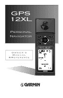
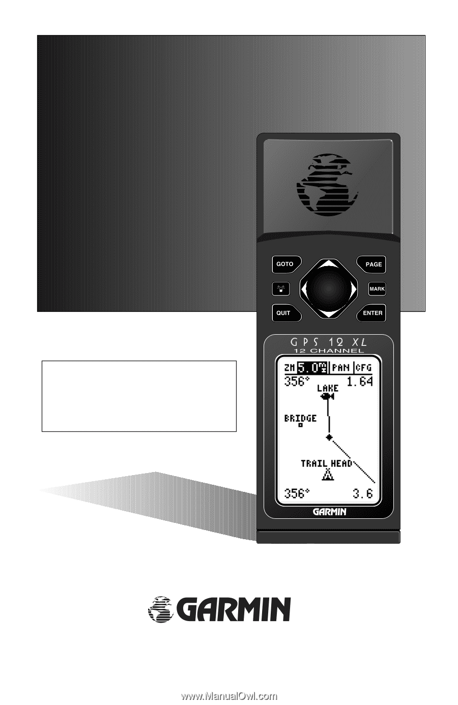
GPS 12XL Personal Navigator Owner's Manual & Reference ® - Garmin GPS 12XL | Owner's Manual (Software Version 2.00-3.62) - Page 2
: www.garmin.com All rights reserved. No part of this manual may be person or organization of such changes. GARMIN, Personal Navigator, AutoLocate, TracBack, and PhaseTrac12 are all trademarks of GARMIN Corporation and may not be used without the expressed permission of GARMIN. June 1997 - Part - Garmin GPS 12XL | Owner's Manual (Software Version 2.00-3.62) - Page 3
• GPS 12XL Unit • Owner's Manual • Wrist Strap • Carrying Case • Quick Reference Guide • 4 AA Batteries See your GARMIN dealer for accessories including our PC kit, swivel mounts, external antennas, and power/data cables. We at GARMIN hope the GPS 12XL will help you meet all of your navigation - Garmin GPS 12XL | Owner's Manual (Software Version 2.00-3.62) - Page 4
the problem. Operation is subject to the following conditions: (1) This device cannot cause harmful interference, and (2) this device must accept any interference received, including interference that may cause undesired operation. The GPS 12XL does not contain any user-serviceable parts. Repairs - Garmin GPS 12XL | Owner's Manual (Software Version 2.00-3.62) - Page 5
Off 11 SECTION THREE Reference Satellite Page 12-13 Battery Level Indicator, Backlighting, and Emergency Erase 14 Position Page & User Selectable Fields 15-16 Marking a Position & Position Averaging Function 17 Waypoint Pages & Managing Waypoints 18-23 TracBack Navigation 24-25 Creating and - Garmin GPS 12XL | Owner's Manual (Software Version 2.00-3.62) - Page 6
Glossary The GPS 12XL is a powerful navigation tool that can guide you anywhere in the world. To better understand its operation and capabilities, it may be helpful to review the basic terms and concepts briefly explained below. Other navigation and GPS definitions used in the manual are defined - Garmin GPS 12XL | Owner's Manual (Software Version 2.00-3.62) - Page 7
the Prime Meridian, an imaginary circle that passes through the north and south poles. Navigation The process of traveling from one place to another and knowing where you are in are traveling in the direction of the destination. Waypoint A specific location saved in the receiver's memory. 3 - Garmin GPS 12XL | Owner's Manual (Software Version 2.00-3.62) - Page 8
(see above). Contact your GARMIN dealer for remote antennas and accessories. The GPS 12XL operates on 4 AA batteries (included), which are installed at the base of the unit. These batteries provide up to 12 hours of use. To install the batteries: 1. Remove the battery cover by turning the thumb - Garmin GPS 12XL | Owner's Manual (Software Version 2.00-3.62) - Page 9
. M Captures a position and displays the mark position page. G Displays GOTO page with the waypoint highlighted for GOTO operation. Pressing GOTO twice activates MOB. E Confirms data entry and activates highlighted fields to allow data entry. Q Returns display to a previous page, or restores - Garmin GPS 12XL | Owner's Manual (Software Version 2.00-3.62) - Page 10
the five primary information pages used for the GPS 12XL. Switch between pages by pressing either the Q or J keys. J Satellite Position Map Compass Menu Q Satellite Page The Satellite Page dimensions: latitude, longitude, and altitude. A trip odometer and 12/24-hour clock are also provided. - Garmin GPS 12XL | Owner's Manual (Software Version 2.00-3.62) - Page 11
and bearing are shown at the top corners of the map. The top of the screen contains the zoom, pan, and configuration fields. Navigation Page A navigation page gives you steering guidance when going to a waypoint. The GPS 12XL has two navigation page choices: the Compass Page and the Highway Page - Garmin GPS 12XL | Owner's Manual (Software Version 2.00-3.62) - Page 12
Page will be replaced by the Position Page. Marking a Position GPS is really about marking and going to places called waypoints. Before we can use our GPS 12XL to guide us somewhere, we have to mark a position as a waypoint. (Your GPS 12XL can hold up to 500 waypoints.) To mark your present - Garmin GPS 12XL | Owner's Manual (Software Version 2.00-3.62) - Page 13
& Going To a Waypoint The Map Page displays your present position as a diamond icon and provides a real-time graphic "breadcrumb" display of your track right on the screen. The GOTO waypoint page allows you to select a destination from a list of all available waypoints in the GPS 12XL's memory. 9 - Garmin GPS 12XL | Owner's Manual (Software Version 2.00-3.62) - Page 14
a destination waypoint, the GPS 12XL provides graphic steering guidance with the Compass Page (the default navigation page). The the screen, is a user-selectable field that can provide a variety of navigation information. We'll cover more about that field in the reference section (see page 36). - Garmin GPS 12XL | Owner's Manual (Software Version 2.00-3.62) - Page 15
through the basic operation of your new GPS receiver and probably know a little more than you think about how it works. We encourage you to experiment with the GPS 12XL until it becomes an extension of your own navigation skills. If you encounter any problems using the unit or want to take advantage - Garmin GPS 12XL | Owner's Manual (Software Version 2.00-3.62) - Page 16
the 'orientation' option on the Map Page. (See pg. 38 for setup instructions.) When the receiver is looking for a particular satellite, receiver is collecting data from it. The satellite number in the sky view will no longer appear highlighted. As soon as the GPS 12XL has collected the necessary data - Garmin GPS 12XL | Owner's Manual (Software Version 2.00-3.62) - Page 17
- the GPS 12XL is initializing and collecting new almanac data. This process can take 5 minutes, depending on the satellites currently in view. Acquiring- the receiver is collecting data from available satellites, but has not collected enough data to calculate a 2D fix. 2D Nav (2D Navigation)- at - Garmin GPS 12XL | Owner's Manual (Software Version 2.00-3.62) - Page 18
Voltage differences will dis- play Ni-Cad and lithium batteries differently . No other receiver functions are affected. The GPS 12XL features an internal lithium battery that will maintain the unit's memory when the receiver is not running off batteries or external power. Backlighting Bulb Icon The - Garmin GPS 12XL | Owner's Manual (Software Version 2.00-3.62) - Page 19
12XL uses this basic information to mark exact positions as waypoints, which help guide you from one place to another. The lower right-hand corner of the page contains the altitude field (default). Below that field is a 12- or 24-hour clock. Both the trip odometer and the altitude fields are user - Garmin GPS 12XL | Owner's Manual (Software Version 2.00-3.62) - Page 20
the GPS 12XL is acquiring satellites or navigating in the 2D mode, the last known altitude is used to compute your position. You may also manually enter your altitude for greater accuracy. In cases where the GPS 12XL has 2D coverage, entering your approximate altitude will enable the receiver to - Garmin GPS 12XL | Owner's Manual (Software Version 2.00-3.62) - Page 21
Marking a Position The GPS 12XL allows you to mark and store up to 500 position as waypoints. A waypoint can be entered by taking an instant electronic fix, by manually entering coordinates (pg. 20), or by using the bearing and distance to a known position (pg. 20). To mark your present position: 1. - Garmin GPS 12XL | Owner's Manual (Software Version 2.00-3.62) - Page 22
stored in the GPS 12XL and their respective waypoint symbols. The total number of empty and used waypoints is also indicated. From the waypoint list page, you can retrieve a waypoint definition page, delete all user-defined waypoints, delete waypoints by symbol, or review and perform a GOTO - Garmin GPS 12XL | Owner's Manual (Software Version 2.00-3.62) - Page 23
. Press Q or P to return to the Menu Page. REFERENCE Waypoint List & Proximity Waypoints Deleting waypoints by symbol enables you to delete a specific group of waypoints without losing all other waypoints. Quickly edit proximity waypoints by highlighting the waypoint name and pressing ENTER. 19 - Garmin GPS 12XL | Owner's Manual (Software Version 2.00-3.62) - Page 24
REFERENCE Waypoint Definition & Reference Waypoints The GPS 12XL's advanced waypoint planning features allow you to create new waypoints and practice navigation without ever setting foot outside. If you create a new waypoint by entering coordinates from a map, you may want to re-mark the waypoint's - Garmin GPS 12XL | Owner's Manual (Software Version 2.00-3.62) - Page 25
on the map. 4. Press E, and select one of the following display options: 'NAME WITH SYMBOL', 'SYMBOL ONLY,' or 'COMMENT WITH SYMBOL'. 5. Press E to confirm your selection, and E again to confirm the 'DONE?' prompt. Waypoint Comments Each waypoint stored in the GPS 12XL has a user- defined 16 - Garmin GPS 12XL | Owner's Manual (Software Version 2.00-3.62) - Page 26
pg. 30), and then delete it. If you attempt to delete a waypoint that's part of a route, you'll be given a "Route Waypoint Can't be Deleted" message. Scanning Waypoints As you manually enter a waypoint's name, the GPS 12XL's waypoint scanning feature will automatically display the first numerical or - Garmin GPS 12XL | Owner's Manual (Software Version 2.00-3.62) - Page 27
. To activate the MOB mode: 1. Press G twice. The GOTO waypoint page will appear with 'MOB' selected. 2 Press E to begin MOB navigation. The GPS 12XL will now guide you to the MOB waypoint until the MOB GOTO is cancelled. If you want to save the MOB waypoint, be sure to rename it because it will be - Garmin GPS 12XL | Owner's Manual (Software Version 2.00-3.62) - Page 28
ENTER to begin TracBack navigation. 24 TracBack Navigation GARMIN's patented TracBack feature allows you to quickly retrace your path using the track log automatically stored in the receiver. This feature eliminates the need to mark waypoints along the way and manually create and activate a route - Garmin GPS 12XL | Owner's Manual (Software Version 2.00-3.62) - Page 29
-digit number available. (You can also quickly delete all temporary TracBack waypoints in memory by using the 'DELETE BY SYMBOL' method described on pg. 19.) REFERENCE TracBack The TracBack feature will navigate your track log back to the oldest point in the receiver's memory. The track log will be - Garmin GPS 12XL | Owner's Manual (Software Version 2.00-3.62) - Page 30
The last form of navigating to a destination with the GPS 12XL is by creating a user-defined route. The route navigation feature lets you plan and navigate a course from one place to another using a set of pre-defined waypoints. Routes are often used when it's not practical, safe, or possible - Garmin GPS 12XL | Owner's Manual (Software Version 2.00-3.62) - Page 31
Distance Function Prompts The last form of navigating to a destination with the GPS 12XL is by creating a user-defined route. The GPS 12XL lets you create and store up to 20 routes of 30 waypoints each. The route navigation feature lets you plan and navigate a course from one place to another using - Garmin GPS 12XL | Owner's Manual (Software Version 2.00-3.62) - Page 32
REFERENCE Using Routes You may use up to 16 characters to custom name a route. The default name will be the first and last waypoint in the route. To activate a route, highlight the 'ACT?' prompt and press ENTER. Creating and Navigating Routes To create a route from the route definition page: 1. - Garmin GPS 12XL | Owner's Manual (Software Version 2.00-3.62) - Page 33
waypoint. As long as you are navigating an active route, the active route page will become part E to copy the route. To clear a route from memory: 1. Highlight the 'ROUTE:' field, and press E. 2. press E. 4. Highlight 'Yes?', and press E. REFERENCE Active Route, Copying, & Clearing Active Route Page - Garmin GPS 12XL | Owner's Manual (Software Version 2.00-3.62) - Page 34
active route page: 1. Highlight the desired route waypoint, and press G. 2. Once the GOTO waypoint page appears with the way- point highlighted, press E. Note that after you reach the on-route GOTO waypoint, the GPS 12XL will automatically resume navigating the rest of the route in sequence using - Garmin GPS 12XL | Owner's Manual (Software Version 2.00-3.62) - Page 35
Selecting a User-Defined Navigation Page Once you've selected a GOTO destination or activated a TracBack, MOB, or route, the GPS 12XL will provide graphic steering guidance to the destination with one of two navigation pages: REFERENCE Navigation Pages Compass Page Highway Page •The Compass Page - Garmin GPS 12XL | Owner's Manual (Software Version 2.00-3.62) - Page 36
REFERENCE Navigation Pages Selecting a User-Defined Navigation Page (cont.) Graphic Compass Distance to Waypoint Use the user selectable field to customize the navigation pages. The turn option will show you the number of degrees you need to turn to head directly to your destination. Track Over - Garmin GPS 12XL | Owner's Manual (Software Version 2.00-3.62) - Page 37
points up, you are going directly to the waypoint. If the arrow points any direction (left, shows your track (TRK), speed (SPD), and a user-selectable field for ETE, ETA, CTS, XTK, VMG on your current speed and track over ground), the GPS 12XL will alert you with a flashing on-screen message box - Garmin GPS 12XL | Owner's Manual (Software Version 2.00-3.62) - Page 38
Waypoint Track Over Ground Destination Waypoint Graphic Highway Distance to Waypoint Speed Over Ground CDI Scale User Selectable Field The GPS 12XL's Highway Page provides graphic steering guidance to a destination waypoint desired track. As you navigate toward a waypoint, the highway will actually - Garmin GPS 12XL | Owner's Manual (Software Version 2.00-3.62) - Page 39
39 for more information). The four corners of the Map Page are used to display various navigation data, including the bearing and distance to a destination waypoint and your current track and speed over the ground. The two fields at the top corners of the map show your bearing and distance to one of - Garmin GPS 12XL | Owner's Manual (Software Version 2.00-3.62) - Page 40
Map Page. On-Screen Pointing The crosshair will "snap" to displayed waypoints, which allows you to quickly review or go to the selected waypoint right from the Map use. Whenever the Map Page first appears, the zoom field (at the top left) is always highlighted. The map has 12 map scales which are - Garmin GPS 12XL | Owner's Manual (Software Version 2.00-3.62) - Page 41
Zooming, Panning, and Configuring (cont.) From the waypoint definition page, you can also define how each individual waypoint is displayed on the map. The GPS 12XL displays waypoints as a name with a corresponding symbol (e.g., "nearest fuel" and a gas pump symbol), a symbol only (e.g., a fish - Garmin GPS 12XL | Owner's Manual (Software Version 2.00-3.62) - Page 42
REFERENCE Using Cursor & Map Setup The 'CFG' field gives access to the map setup and track setup pages, right from the Map Page. The Map set a course for a new waypoint called 'MAP'. To go to the target crosshair: 1. Press G, and press E. To save the MAP waypoint, be sure to rename it because - Garmin GPS 12XL | Owner's Manual (Software Version 2.00-3.62) - Page 43
waypoints. • 'Track Log'- displays and plots track points on the map. To turn a map item on or off: 1. Highlight 'YES' or 'NO' for the specific map item, and press E. Track Setup Page The track setup page lets you manage the GPS 12XL's track log data use of track memory and provides the best - Garmin GPS 12XL | Owner's Manual (Software Version 2.00-3.62) - Page 44
the TracBack feature. Menu Page The GPS 12XL's Menu Page provides access to additional pages (submenus) that are used to select and customize operation and navigation setup. These eight pages are divided into categories by function. We've already gone over the waypoint and route management pages in - Garmin GPS 12XL | Owner's Manual (Software Version 2.00-3.62) - Page 45
. The GPS 12XL has two operating modes: • Normal Mode operates the unit at maximum performance, and provides battery life of up to 12 hours on alkaline batteries. • Simulator Mode allows you to operate the unit without acquiring satellites, and is ideal for practicing or entering waypoints and - Garmin GPS 12XL | Owner's Manual (Software Version 2.00-3.62) - Page 46
The "Stay On" setting will keep your backlighting on continuously. However, this will significantly reduce your battery life. The tone setting has three options to customize it to your preference. 42 The GPS 12XL has adjustable screen contrast controlled by an on-screen bar scale. To set the screen - Garmin GPS 12XL | Owner's Manual (Software Version 2.00-3.62) - Page 47
navigation setup submenu page is used to select units of measurement for position formats, map datums, CDI scale, units, and heading information. Position Formats The default position format for the GPS 12XL press E. User Grid Position Format The user grid option lets you create a user defined - Garmin GPS 12XL | Owner's Manual (Software Version 2.00-3.62) - Page 48
44 Map Datums (continued) To define a user datum: 1. Highlight the 'MAP DATUM' field, and press E. 2. Scroll through the map datum options until 'User' E. 2. Select the desired setting, and press E. Units of Measure The GPS 12XL lets you select statute (default), nau- tical, or metric units of - Garmin GPS 12XL | Owner's Manual (Software Version 2.00-3.62) - Page 49
information such as waypoints, routes, and track logs between two GARMIN GPS units or a GARMIN GPS and a PC. There are eight data transfer options: send receiver with no output capability; and RTCM/NMEA, which allows DGPS input and NMEA output. Once a RTCM setting has been selected, the GPS 12XL - Garmin GPS 12XL | Owner's Manual (Software Version 2.00-3.62) - Page 50
received, a 'No Data' message will be displayed. • If a beacon signal cannot be tuned, a 'No Status' message will be displayed. The message page will alert you to any problems relating to DGPS operation. You may also monitor the DGPS status from the status field on the interface page. The GPS 12XL - Garmin GPS 12XL | Owner's Manual (Software Version 2.00-3.62) - Page 51
(from the Position Page). ! The GPS 12XL does not track satellites in simulator mode. Although you can create and save waypoints and routes while using the simulator mode, never attempt to use the simulator mode for actual navigation. REFERENCE Navigation Simulator Select the simulator mode from - Garmin GPS 12XL | Owner's Manual (Software Version 2.00-3.62) - Page 52
page will be replaced by the Satellite Page, with the EZinit prompt ready for you to select one of two initialization methods: •Select Country--allows you to initialize the receiver by selecting your present position from a list of countries in the GPS 12XL's internal database. This usually provides - Garmin GPS 12XL | Owner's Manual (Software Version 2.00-3.62) - Page 53
of your present position. 5. Press E to finish. The GPS 12XL will now begin searching for the appropriate satellites for your location top-left corner of the Satellite Page. Initialization Troubleshooting If you have trouble initializing the receiver or acquiring a position, check the following: • - Garmin GPS 12XL | Owner's Manual (Software Version 2.00-3.62) - Page 54
Size: 14.6 x 5.1 x 3.4 cm Weight: Approx 9.5 ounces (269g) w/ batteries Temperature Range: 5º to 158ºF (-15º to 70ºC) PERFORMANCE Receiver: Acquisition Time: Update Rate: Position Accuracy: Velocity Accuracy: Dynamics: 12 parallel channel, differential-ready Approx. 15 seconds (warm start) Approx - Garmin GPS 12XL | Owner's Manual (Software Version 2.00-3.62) - Page 55
support waypoint symbols such as the GPS II plus, GPS 12, and GPS 12XL software version 3.01 or later. Part No. 010-10142-00. • PC Kit Interface Cable- PC interface cable with 9-pin 'D' serial data connector. Part estimated error), PGRMM (map datum), PSLIB (beacon receiver control) DGPS corrections - Garmin GPS 12XL | Owner's Manual (Software Version 2.00-3.62) - Page 56
in the GPS 12XL's memory. Approaching-You are one minute away from reaching a destination waypoint. Battery Power is Low-The batteries are low and should be replaced. No DGPS Position-Not enough data is available to compute a DGPS position. No RTCM Input-Beacon receiver is improperly connected - Garmin GPS 12XL | Owner's Manual (Software Version 2.00-3.62) - Page 57
signal. Searching the Sky-The GPS 12XL is in searching the sky for almanac data or the unit is in AutoLocateTM mode. Stored Data was Lost-All waypoints, routes, time and almanac data has been lost due to battery failure or clearing the receiver's memory. Track Memory is Full-All track log points - Garmin GPS 12XL | Owner's Manual (Software Version 2.00-3.62) - Page 58
Datums The following list shows the map datums available for the GPS 12XL. Menu abbreviations are listed first, followed by the corresponding map datum name and area. The default map datum for the GPS 12XL is WGS 84. Adindan Afgooye AIN EL ABD '70 Anna 1 Ast '65 ARC 1950 ARC 1960 Ascnsn Isld '58 - Garmin GPS 12XL | Owner's Manual (Software Version 2.00-3.62) - Page 59
'69 South Asia SE Base SW Base Timbalai 1948 Tokyo Tristan Ast '68 Viti Levu 1916 Wake-Eniwetok WGS 72 WGS 84 Zanderij APPENDIX D Map Datums Prov So Amricn '56- Bolivia, Chile,Colombia, Ecuador, Guyana, Peru, Venezuela Prov So Chilean '63- S. Chile Puerto Rico & Virgin Islands Qatar National- Qatar - Garmin GPS 12XL | Owner's Manual (Software Version 2.00-3.62) - Page 60
.7, 10, 31, 33 Configuring the Map Page 38 Copying Routes 29 Course deviation indicator 44 Course to Steer (CTS) . . .32 Creating Routes 28 Crosstrack Error (XTK) . .32 Customer Service Dept. . .59 D DGPS Interface 45 Date and Time 41 Deleting Waypoints . . . . .22 Distance/Sun Calculations 40 - Garmin GPS 12XL | Owner's Manual (Software Version 2.00-3.62) - Page 61
6, 15 Power and Data Cables . . .51 Pre-defined waypoints . . .27 Primary Pages 6 Proximity Waypoints . . . .19 R Receiver Status 13 Reference Waypoints . . . .20 Renaming Waypoints . . . .22 Repairs 50 Routes Clearing 29 Copying 29 Creating 28 Editing 30 Inverting 28 Navigating Routes - Garmin GPS 12XL | Owner's Manual (Software Version 2.00-3.62) - Page 62
Trip Timer (TTIME) . . . . .15 Troubleshooting 49 Turn (TRN 32 Trip odometer 15 Reference Waypoints . . .20 Renaming 22 Waypoint List 19 Waypoint Pages . . . . . .18 Waypoint Symbols .21, 37 Z Zooming 36 U Units of Measure 44 User-defined route . . . . . .27 User Grid 43 Using the Keypad - Garmin GPS 12XL | Owner's Manual (Software Version 2.00-3.62) - Page 63
the outside of the package, and sent freight prepaid and insured to a GARMIN warranty service station. A copy of the original sales receipt is required as the proof of purchase for warranty repairs. GARMIN retains the exclusive right to repair or replace the unit or software at its sole discretion. - Garmin GPS 12XL | Owner's Manual (Software Version 2.00-3.62) - Page 64
® © 1997 GARMIN Corporation 1200 E. 151st Street, Olathe, KS USA 66062 GARMIN (Europe) Ltd. - Unit 5, The Quadrangle, Abbey Park, Romsey, Hampshire, SO51 9AQ, UK Part Number 190-00134-00 Rev. C Printed in Taiwan
-
 1
1 -
 2
2 -
 3
3 -
 4
4 -
 5
5 -
 6
6 -
 7
7 -
8
-
9
-
10
-
11
-
12
-
13
-
14
-
15
-
16
-
17
-
18
-
19
-
20
-
21
-
22
-
23
-
24
-
25
-
26
-
27
-
28
-
29
-
30
-
31
-
32
-
33
-
34
-
35
-
36
-
37
-
38
-
39
-
40
-
41
-
42
-
43
-
44
-
45
-
46
-
47
-
48
-
49
-
50
-
51
-
52
-
53
-
54
-
55
-
56
-
57
-
58
-
59
-
60
-
61
-
62
-
63
-
64
 |
 |
Owner’s
Manual
&Reference
GPS
12XL
Personal
Navigator
®