Garmin GPSMAP 296 Pilot's Guide - Page 12
Getting Satellite Signals, Viewing GPS Status With the GPS Tab
 |
View all Garmin GPSMAP 296 manuals
Add to My Manuals
Save this manual to your list of manuals |
Page 12 highlights
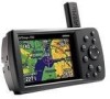
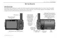
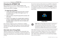
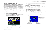
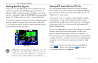
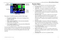
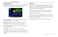
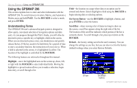
GETTING STARTED > GETTING SATELLITE SIGNALS Getting Satellite Signals After you turn on the GPSMAP 296, the unit automatically begins searching for satellites. The GPS Page appears while the unit is gathering satellite signals and acquiring a fix. This process should take only a few minutes. While the GPSMAP 296 is getting satellite signals, the GPS Page shows the status as "Acquiring Satellites." It can take a few minutes to acquire satellites and show your current location on the map. Be patient as the unit acquires satellite data. To get signals more quickly, be sure the antenna is raised to the up location shown in the image on page 1. GPS Tab NOTE: While acquiring satellites, the Map Page can show the wrong location, such as China. This does not mean your unit has the wrong data loaded. The GPS receiver needs a few more minutes to acquire satellites and find your current location. 4 Viewing GPS Status With the GPS Tab The GPS tab provides a visual reference of satellite acquisition, receiver status, and accuracy. The sky view and signal strength bars give an indication of what satellites are visible to the receiver and whether they are being tracked. As the receiver locks onto satellites, a signal strength bar appears for each satellite in view, with the appropriate satellite number underneath each bar. The numbers shown below each bar represent the particular satellite that is being received. Numbers above 33 indicate WAAS satellites. The sky view shows a birds-eye view of the location of each satellite relative to the receiver's last known location. The outer circle represents the horizon (north up), the inner circle represents 45º above the horizon, and the center point represents a location directly overhead. You can also set the sky view to a Track Up configuration, causing the top of the sky view to align along your current track heading. A power source indicator shows the unit is operating off battery power ( ), that the unit is charging ( ), or that an external power source is in use ( ). GPSMAP 296 Pilot's Guide
-
 1
1 -
2
-
3
-
4
-
5
-
6
-
 7
7 -
 8
8 -
 9
9 -
 10
10 -
 11
11 -
 12
12 -
 13
13 -
 14
14 -
 15
15 -
 16
16 -
 17
17 -
18
-
19
-
20
-
21
-
22
-
23
-
24
-
25
-
26
-
27
-
28
-
29
-
30
-
31
-
32
-
33
-
34
-
35
-
36
-
37
-
38
-
39
-
40
-
41
-
42
-
43
-
44
-
45
-
46
-
47
-
48
-
49
-
50
-
51
-
52
-
53
-
54
-
55
-
56
-
57
-
58
-
59
-
60
-
61
-
62
-
63
-
64
-
65
-
66
-
67
-
68
-
69
-
70
-
71
-
72
-
73
-
74
-
75
-
76
-
77
-
78
-
79
-
80
-
81
-
82
-
83
-
84
-
85
-
86
-
87
-
88
-
89
-
90
-
91
-
92
-
93
-
94
-
95
-
96
-
97
-
98
-
99
-
100
-
101
-
102
-
103
-
104
-
105
-
106
-
107
-
108
-
109
-
110
-
111
-
112
-
113
-
114
-
115
-
116
-
117
-
118
-
119
-
120
-
121
-
122
-
123
-
124
-
125
-
126
-
127
-
128
-
129
-
130
-
131
-
132
-
133
-
134
-
135
-
136
-
137
-
138
-
139
-
140
-
141
-
142
-
143
-
144
-
145
-
146
-
147
-
148
-
149
-
150
-
151
-
152
-
153
-
154
-
155
-
156
-
157
-
158
-
159
-
160
-
161
-
162
-
163
-
164
-
165
-
166
-
167
-
168
 |
 |
