Garmin GPSMAP 296 Pilot's Guide - Page 137
Transducer Coverage, cannot show a large coverage area for finding fish. The 10° cone
 |
View all Garmin GPSMAP 296 manuals
Add to My Manuals
Save this manual to your list of manuals |
Page 137 highlights
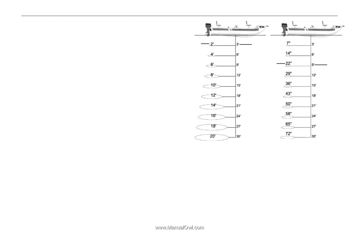
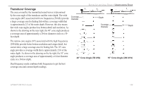
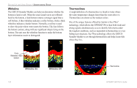
SETTING UP AND USING SONAR > UNDERSTANDING SONAR Transducer Coverage The area covered by the transmitted sound waves is determined by the cone angle of the transducer and the water depth. The wide cone angles (40°) associated with low frequencies (50 kHz) provide Coverage Diameter Depth a large coverage area for finding fish within a coverage width that is approximately 2/3 of the water depth. However, this also means that wide cone angles produce less bottom detail and resolution. As Coverage Diameter Depth shown in the drawing on the near right, the 40° cone angle produces a coverage area of approximately a 20-foot diameter circle at a 30- foot depth. The narrow cone angles (10°) associated with the high frequencies (200 kHz) provide better bottom resolution and crisper detail, but cannot show a large coverage area for finding fish. The 10° cone angle provides a coverage width that is approximately 2/10 of the water depth. As shown in the drawing on the far right, the 10° cone angle produces a coverage area of approximately a 6-foot diameter circle at a 30-foot depth. 40° Cone Angle (50 kHz) 10° Cone Angle (200 kHz) Dual frequency mode combines both frequencies to get the best coverage area and contour/depth readings. GPSMAP 296 Pilot's Guide 129
-
 1
1 -
2
-
3
-
4
-
5
-
6
-
7
-
8
-
9
-
10
-
11
-
12
-
13
-
14
-
15
-
16
-
17
-
18
-
19
-
20
-
21
-
22
-
23
-
24
-
25
-
26
-
27
-
28
-
29
-
30
-
31
-
32
-
33
-
34
-
35
-
36
-
37
-
38
-
39
-
40
-
41
-
42
-
43
-
44
-
45
-
46
-
47
-
48
-
49
-
50
-
51
-
52
-
53
-
54
-
55
-
56
-
57
-
58
-
59
-
60
-
61
-
62
-
63
-
64
-
65
-
66
-
67
-
68
-
69
-
70
-
71
-
72
-
73
-
74
-
75
-
76
-
77
-
78
-
79
-
80
-
81
-
82
-
83
-
84
-
85
-
86
-
87
-
88
-
89
-
90
-
91
-
92
-
93
-
94
-
95
-
96
-
97
-
98
-
99
-
100
-
101
-
102
-
103
-
104
-
105
-
106
-
107
-
108
-
109
-
110
-
111
-
112
-
113
-
114
-
115
-
116
-
117
-
118
-
119
-
120
-
121
-
122
-
123
-
124
-
125
-
126
-
127
-
128
-
129
-
130
-
131
-
 132
132 -
 133
133 -
 134
134 -
 135
135 -
 136
136 -
 137
137 -
 138
138 -
 139
139 -
 140
140 -
 141
141 -
 142
142 -
143
-
144
-
145
-
146
-
147
-
148
-
149
-
150
-
151
-
152
-
153
-
154
-
155
-
156
-
157
-
158
-
159
-
160
-
161
-
162
-
163
-
164
-
165
-
166
-
167
-
168
 |
 |