Garmin GPSMAP 296 Pilot's Guide - Page 163
Maritime Mobile Service Identity., Land at Closest Point - 76s
 |
View all Garmin GPSMAP 296 manuals
Add to My Manuals
Save this manual to your list of manuals |
Page 163 highlights
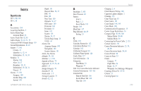
I Icons 108 Identifier 6, 12, 14, 17, 144, 146 Information Page 31, 55 Initialize 3, 139 Installation Information 135-138 Intersection 146 J Jeppesen Database 26, 146 Updates 10 K Keypad 7 L Land at Closest Point 18 Language 110 Legs, Track 85 Limited Warranty 152 Lithium-ion 1, 2 Local Time 113 Location 6, 60 Location Format 114, 143 Locked Route 26 Log Filter 107 Longitude 149 LORAN TD Setup 141-142 Lost Satellite Reception 5 GPSMAP 296 Pilot's Guide M Magnetic Variation 115 Main Menu Display Tab 108 GPS tab 4 Sound Tab 109 Managing Routes 69 Managing Tracks 82 Managing Waypoints 73 Man OverBoard 87 Map Information 35, 55 MapSource 10, 137 Map Data 35 Map Datum 143 Map Orientation 29 Map Page Automotive Mode 64 Aviation Mode 28-35 Declutter 32 Marine Mode 88 Setup 33 Marine Timer 90 Maritime Mobile Service Identity. See MMSI Marking a Waypoint 25, 58, 59, 60, 76 Underwater 124 Mark my Location 25 Maximum Speed 46 MayDay 145 Measuring Distance 32 Messages 107, 151 Military Time 113 Mils 114 MMSI 91, 144, 145 MOB 87 Modes 50, 110 Moon Information 103 N Navigate Route 70 To Point 87 Track 85 Navigating Distress Call 95 Position Report 95 Navigating in Automotive Mode 51-52 Navigating in Marine Mode 87 Navigation Alarms 100 NDB 17, 146 Near Current Route 54, 55 Destination 54, 55 Next 54, 55 Other 54, 55 NEAREST/FIND key 17 Nearest Type 44, 68 New Altitude 6 Location 6, 12 Waypoint 60, 76 Next Turn 100, 112 NMEA 116, 118, 119, 138 North Up 6, 29 No Beacon Signal 140 O OBS 40 Obstacle Alert 27 Odometer 68 Off-Route Recalculation 112 Off Course 100 Off Road 111 On-Screen Button 8 Options Menu 9 Overzoom 29 P Page Layout 34 Page Sequence 86 Panel Page Aviation Mode 39-42 Panning the Map 28, 30 Pan Mode 28, 30 PC Interface Cable 136 Persistent Alarm 100 Plan Flight 43, 72, 102 INDEX 155
-
 1
1 -
2
-
3
-
4
-
5
-
6
-
7
-
8
-
9
-
10
-
11
-
12
-
13
-
14
-
15
-
16
-
17
-
18
-
19
-
20
-
21
-
22
-
23
-
24
-
25
-
26
-
27
-
28
-
29
-
30
-
31
-
32
-
33
-
34
-
35
-
36
-
37
-
38
-
39
-
40
-
41
-
42
-
43
-
44
-
45
-
46
-
47
-
48
-
49
-
50
-
51
-
52
-
53
-
54
-
55
-
56
-
57
-
58
-
59
-
60
-
61
-
62
-
63
-
64
-
65
-
66
-
67
-
68
-
69
-
70
-
71
-
72
-
73
-
74
-
75
-
76
-
77
-
78
-
79
-
80
-
81
-
82
-
83
-
84
-
85
-
86
-
87
-
88
-
89
-
90
-
91
-
92
-
93
-
94
-
95
-
96
-
97
-
98
-
99
-
100
-
101
-
102
-
103
-
104
-
105
-
106
-
107
-
108
-
109
-
110
-
111
-
112
-
113
-
114
-
115
-
116
-
117
-
118
-
119
-
120
-
121
-
122
-
123
-
124
-
125
-
126
-
127
-
128
-
129
-
130
-
131
-
132
-
133
-
134
-
135
-
136
-
137
-
138
-
139
-
140
-
141
-
142
-
143
-
144
-
145
-
146
-
147
-
148
-
149
-
150
-
151
-
152
-
153
-
154
-
155
-
156
-
157
-
 158
158 -
 159
159 -
 160
160 -
 161
161 -
 162
162 -
 163
163 -
 164
164 -
 165
165 -
 166
166 -
 167
167 -
 168
168
 |
 |