Garmin GPSMAP 296 Pilot's Guide - Page 37
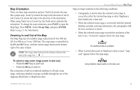
Map Orientation, Zooming In and Out of the Map, Set up Map, ENTER
 |
View all Garmin GPSMAP 296 manuals
Add to My Manuals
Save this manual to your list of manuals |
Page 37 highlights
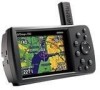
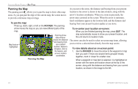
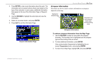
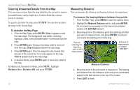
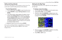
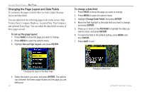
Map Orientation There are three map orientation options: North Up orients the map like a paper map, Track Up orients the map in the direction of travel, and Course Up orients the map in the direction of the destination. When using Track Up or Course Up, the North arrow indicates the orientation. To change the map orientation, press PAGE to open the Map Page. Press MENU. Select Set up Map, and press ENTER. Refer to page 33 for information. Zooming In and Out of the Map The Map Page has 28 available range scales from 20 ft to 800 nm (20 ft to 800 mi or 5 m to 1200 km). The map range is controlled by the IN and OUT keys, with the current range shown at the bottom right of the data window. NOTE: The range value represents the distance between the ends of the range bar ( ). AVIATION MODE PAGES > MAP PAGE Map coverage conforms to the following conditions: • Cartography is shown when the selected zoom range is covered by either the internal basemap or other MapSource data loaded onto a data card. • When the selected zoom range is covered by both the internal database and data card map information, the cartography with the best resolution is shown. • When the selected zoom range exceeds the resolution of the data in use, "overzoom" appears below the map range. No additional data is available • When external data (such as MapSource data) is used, "map card" appears below the map range. To select a map zoom range (zoom in and out): • Press the OUT key to zoom out. • Press the IN key to zoom in. The system has a built-in worldwide database to 20 mile zoom range, with more detailed coverage available through the use of the Jeppesen, BlueChart, or MapSource data. Using detailed maps loaded on the data card GPSMAP 296 Pilot's Guide 29
-
 1
1 -
2
-
3
-
4
-
5
-
6
-
7
-
8
-
9
-
10
-
11
-
12
-
13
-
14
-
15
-
16
-
17
-
18
-
19
-
20
-
21
-
22
-
23
-
24
-
25
-
26
-
27
-
28
-
29
-
30
-
31
-
 32
32 -
 33
33 -
 34
34 -
 35
35 -
 36
36 -
 37
37 -
 38
38 -
 39
39 -
 40
40 -
 41
41 -
 42
42 -
43
-
44
-
45
-
46
-
47
-
48
-
49
-
50
-
51
-
52
-
53
-
54
-
55
-
56
-
57
-
58
-
59
-
60
-
61
-
62
-
63
-
64
-
65
-
66
-
67
-
68
-
69
-
70
-
71
-
72
-
73
-
74
-
75
-
76
-
77
-
78
-
79
-
80
-
81
-
82
-
83
-
84
-
85
-
86
-
87
-
88
-
89
-
90
-
91
-
92
-
93
-
94
-
95
-
96
-
97
-
98
-
99
-
100
-
101
-
102
-
103
-
104
-
105
-
106
-
107
-
108
-
109
-
110
-
111
-
112
-
113
-
114
-
115
-
116
-
117
-
118
-
119
-
120
-
121
-
122
-
123
-
124
-
125
-
126
-
127
-
128
-
129
-
130
-
131
-
132
-
133
-
134
-
135
-
136
-
137
-
138
-
139
-
140
-
141
-
142
-
143
-
144
-
145
-
146
-
147
-
148
-
149
-
150
-
151
-
152
-
153
-
154
-
155
-
156
-
157
-
158
-
159
-
160
-
161
-
162
-
163
-
164
-
165
-
166
-
167
-
168
 |
 |