Garmin GPSMAP 441s Owner's Manual - Page 36
Creating and Using Waypoints, Waypoints & Tracks
 |
View all Garmin GPSMAP 441s manuals
Add to My Manuals
Save this manual to your list of manuals |
Page 36 highlights
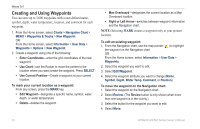
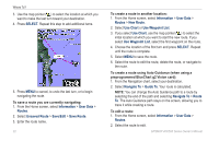
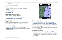
Where To? Creating and Using Waypoints You can store up to 3,000 waypoints with a user-defined name, symbol, depth, water temperature, location, and comment for each waypoint. 1. From the Home screen, select Charts > Navigation Chart > MENU > Waypoints & Tracks > New Waypoint. OR From the Home screen, select Information > User Data > Waypoints > Options > New Waypoint. 2. Create a waypoint using one of the following: • Enter Coordinates-enter the grid coordinates of the new waypoint. • Use Chart-use the Rocker to move the pointer to the location where you want create the waypoint. Press SELECT. • Use Current Position-Create a waypoint at your current location. To mark your current location as a waypoint: From any screen, press the MARK key. • Edit Waypoint-designate a specific name, symbol, water depth, or water temperature. • Delete-deletes the waypoint. • Man Overboard-designates the current location as a Man Overboard location. • Right or Left Arrow-switches between waypoint information and the Navigation chart. Note: Selecting MARK creates a waypoint only at your present location. To edit an existing waypoint: 1. From the Navigation chart, use the map pointer ( ) to highlight the waypoint on the Navigation chart. OR From the Home screen, select Information > User Data > Waypoints. 2. Select the waypoint you want to edit. 3. Select Edit Waypoint. 4. Select the waypoint attribute you want to change (Name, Symbol, Depth, Water Temp, Comment, or Position). To move the waypoint on the Navigation chart: 1. Select the waypoint on the Navigation chart. 2. Select Review. (The Review button is only shown when more than one waypoint is in the vicinity.) 3. Select the button for the waypoint you want to edit. 4. Select Move. 30 GPSMAP 400/500 Series Owner's Manual
-
 1
1 -
2
-
3
-
4
-
5
-
6
-
7
-
8
-
9
-
10
-
11
-
12
-
13
-
14
-
15
-
16
-
17
-
18
-
19
-
20
-
21
-
22
-
23
-
24
-
25
-
26
-
27
-
28
-
29
-
30
-
 31
31 -
 32
32 -
 33
33 -
 34
34 -
 35
35 -
 36
36 -
 37
37 -
 38
38 -
 39
39 -
 40
40 -
 41
41 -
42
-
43
-
44
-
45
-
46
-
47
-
48
-
49
-
50
-
51
-
52
-
53
-
54
-
55
-
56
-
57
-
58
-
59
-
60
-
61
-
62
-
63
-
64
-
65
-
66
-
67
-
68
-
69
-
70
-
71
-
72
-
73
-
74
-
75
-
76
-
77
-
78
-
79
-
80
-
81
-
82
-
83
-
84
-
85
-
86
-
87
-
88
-
89
-
90
-
91
-
92
-
93
-
94
-
95
-
96
 |
 |