Garmin GPSMAP 441s Owner's Manual - Page 74
Using XM WX Weather and Audio, Using XM WX Weather
 |
View all Garmin GPSMAP 441s manuals
Add to My Manuals
Save this manual to your list of manuals |
Page 74 highlights
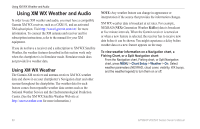
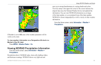
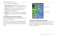
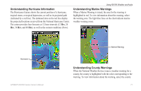
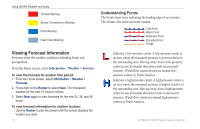
Using XM WX Weather and Audio Using XM WX Weather and Audio In order to use XM weather and audio, you must have a compatible Garmin XM WX receiver, such as a GXM 51, and an activated XM subscription. Visit http://www8.garmin.com/xm/ for more information. To connect the XM antenna and receiver and for subscription instructions, refer to the manual for your XM equipment. If you do not have a receiver and a subscription to XM WX Satellite Weather, the weather features described in this section work only when the chartplotter is in Simulator mode. Simulator mode does not provide live weather data. Using XM WX Weather The Garmin XM receiver and antenna receives XM WX weather data and shows it on your chartplotter's Navigation chart and other screens throughout the chartplotter. The weather data for each feature comes from reputable weather data centers such as the National Weather Service and the Hydrometerological Prediction Center. (See the XM WX Satellite Weather Web site at http://xmwxweather.com for more information.) Note: Any weather feature can change in appearance or interpretation if the source that provides the information changes. XM WX weather data is broadcast at set rates. For example, NEXRAD (NEXt Generation Weather RADar) data is broadcast at five minute intervals. When the Garmin receiver is turned on or when a new feature is selected, the receiver has to receive new data before it can be shown. You might experience a delay before weather data or a new feature appears on the map. To view weather information on a Navigation chart, a Fishing Chart, or a Split Navigation chart: From the Navigation chart, Fishing chart, or Split Navigation chart, press MENU > Chart Setup > Weather > On. Select weather parameters (NEXRAD, cloud cover, visibility, WX buoys, and the weather legend) to turn them on or off. 68 GPSMAP 400/500 Series Owner's Manual
-
 1
1 -
2
-
3
-
4
-
5
-
6
-
7
-
8
-
9
-
10
-
11
-
12
-
13
-
14
-
15
-
16
-
17
-
18
-
19
-
20
-
21
-
22
-
23
-
24
-
25
-
26
-
27
-
28
-
29
-
30
-
31
-
32
-
33
-
34
-
35
-
36
-
37
-
38
-
39
-
40
-
41
-
42
-
43
-
44
-
45
-
46
-
47
-
48
-
49
-
50
-
51
-
52
-
53
-
54
-
55
-
56
-
57
-
58
-
59
-
60
-
61
-
62
-
63
-
64
-
65
-
66
-
67
-
68
-
 69
69 -
 70
70 -
 71
71 -
 72
72 -
 73
73 -
 74
74 -
 75
75 -
 76
76 -
 77
77 -
 78
78 -
 79
79 -
80
-
81
-
82
-
83
-
84
-
85
-
86
-
87
-
88
-
89
-
90
-
91
-
92
-
93
-
94
-
95
-
96
 |
 |