Garmin GPSMAP 5015 Technical Reference for Garmin NMEA 2000 Products
Garmin GPSMAP 5015 Manual
 |
View all Garmin GPSMAP 5015 manuals
Add to My Manuals
Save this manual to your list of manuals |
Garmin GPSMAP 5015 manual content summary:
- Garmin GPSMAP 5015 | Technical Reference for Garmin NMEA 2000 Products - Page 1
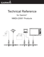
Technical Reference for Garmin® NMEA 2000® Products + - - Garmin GPSMAP 5015 | Technical Reference for Garmin NMEA 2000 Products - Page 2
of such changes or improvements. Visit the Garmin Web site (www.garmin.com) for current updates and supplemental information concerning the use and operation of this and other Garmin products. Garmin®, the Garmin logo, and GPSMAP® are trademarks of Garmin Ltd. or its subsidiaries, registered in the - Garmin GPSMAP 5015 | Technical Reference for Garmin NMEA 2000 Products - Page 3
installation instructions provided with the Garmin NMEA 2000-certified device. Sensor configuration information is also included in a Sensor Configuration Guide provided with each Garmin NMEA 2000-certified sensor. • At the end is a checklist. Use this checklist when installing a NMEA 2000 network - Garmin GPSMAP 5015 | Technical Reference for Garmin NMEA 2000 Products - Page 4
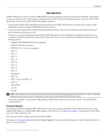
a NMEA 2000 Network...3 Existing NMEA 2000 Installation Considerations...8 NMEA 2000 Glossary...8 General NMEA 2000 Data Type Requirements...9 NMEA 2000-Certified Display Device PGN Information...13 NMEA 2000-Certified Sensor PGN Information...18 GPS 17x (GPS Antenna)...18 GFS 10 (Garmin Fuel Sensor - Garmin GPSMAP 5015 | Technical Reference for Garmin NMEA 2000 Products - Page 5
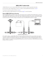
8. After you have installed your NMEA 2000 network, use the checklist on page 37 to verify the installation. Garmin NMEA 2000 Device Overview Garmin uses NMEA 2000 micro connectors on units, sensors, and T-connectors that are compatible with other NMEA 2000 micro connectors, cables, and NMEA 2000 - Garmin GPSMAP 5015 | Technical Reference for Garmin NMEA 2000 Products - Page 6
** (not pictured) 010-11171-02 * The field-installable connectors are used to create custom-length drop cables and custom-length backbone extension cables. The field-installable connectors can be used to shorten any Garmin NMEA 2000 drop/backbone cable. ** The gray in-line lightning arrestor is - Garmin GPSMAP 5015 | Technical Reference for Garmin NMEA 2000 Products - Page 7
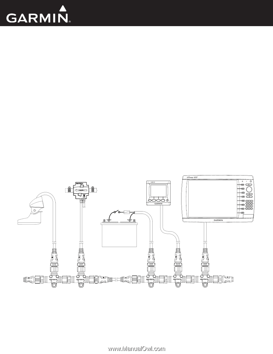
instrument Chartplotter Intelligent transducer Ignition or in-line switch Fuse Female terminator + - Battery - 12 Vdc Power cable Backbone extension cable Drop cable T-connector Male terminator NMEA 2000 backbone Sample NMEA 2000 Network Note: This diagram illustrates the NMEA 2000 data - Garmin GPSMAP 5015 | Technical Reference for Garmin NMEA 2000 Products - Page 8
construct your NMEA 2000 backbone, and extend the backbone with appropriate lengths of backbone cable if necessary. Use one T-connector per device. Use the sides of the T-connector to construct the backbone of the NMEA 2000 network, and use the top of the T-connector to attach a NMEA 2000 device. By - Garmin GPSMAP 5015 | Technical Reference for Garmin NMEA 2000 Products - Page 9
or in the middle. When planning where to place the power cable and the T-connector on your NMEA 2000 network, you will need to evaluate how the NMEA 2000 devices connected to your network use power. The NMEA 2000 network will work properly when there is no more than a 3 Vdc drop in the supply - Garmin GPSMAP 5015 | Technical Reference for Garmin NMEA 2000 Products - Page 10
m Backbone cable Length = 10 m When the NMEA 2000 network is redesigned with the power source in the center, you calculate the voltage drop in both directions. If the T-connector to which you connect the power source is connected directly to another T-connector (as shown in this example), use the - Garmin GPSMAP 5015 | Technical Reference for Garmin NMEA 2000 Products - Page 11
one female terminator and one male terminator. Install the terminators at opposite ends of your NMEA 2000 network. To NMEA 2000 devices and power Female terminator Backbone extension cable Male terminator Using Standard Terminators 2. In-line Terminators If one or both of the NMEA 2000 devices - Garmin GPSMAP 5015 | Technical Reference for Garmin NMEA 2000 Products - Page 12
an existing NMEA 2000 installation, and you would like to add Garmin NMEA 2000 equipment, there are a few things to consider: Cable Type: Garmin uses NMEA 2000 micro connectors for all cables and connectors. Your existing NMEA 2000 network may use NMEA 2000 mini connectors and cables in the backbone - Garmin GPSMAP 5015 | Technical Reference for Garmin NMEA 2000 Products - Page 13
series chartplotter or a GMI 10) on the NMEA 2000 network. The data you can view on your display device depends on the sensors you have installed and configured. Refer to the following table for a list of data types that you can view on a display device; specific NMEA 2000 PGN information required - Garmin GPSMAP 5015 | Technical Reference for Garmin NMEA 2000 Products - Page 14
- COG/SOG, 129029 - GNSS Position, and 129284 - Nav Data Garmin Chartplotter and GPS Antenna 129026 - COG/SOG and 129029 - GNSS Position GPS Antenna 129026 - COG/SOG and 129029 - GNSS Position GPS Antenna 129026 - COG/SOG and 129029 - GNSS Position GPS Antenna 129026 - COG/SOG and 129029 - GNSS - Garmin GPSMAP 5015 | Technical Reference for Garmin NMEA 2000 Products - Page 15
, a less-accurate reading can be calculated using a GPS antenna instead [129026 - COG/SOG and 129029 - GNSS Position]) Either a Wind Sensor and Speed Sensor or a Wind Sensor and a GPS Antenna Waypoint VMG 129284 - Nav Data Garmin Chartplotter and GPS Antenna Maximum Apparent Wind Speed 130306 - Garmin GPSMAP 5015 | Technical Reference for Garmin NMEA 2000 Products - Page 16
Date Timer Unit Voltage PGN Data Required 128267 - Water Depth 130312 Transducer Water Temperature Sensor Water Speed Sensor GPS Antenna, Water Speed Sensor, and Heading Sensor GPS Antenna, Water Speed Sensor, and Heading Sensor GPS Antenna GPS Antenna None None 12 Technical Reference for Garmin - Garmin GPSMAP 5015 | Technical Reference for Garmin NMEA 2000 Products - Page 17
2000-certified display devices. For NMEA 2000 configuration information on every available Garmin NMEA 2000-certified display device, see the owner's manual for your display device. GPSMAP 6000/7000 Series Chartplotters Receive 059392 ISO Acknowledgment 059904 ISO Request 060928 ISO Address - Garmin GPSMAP 5015 | Technical Reference for Garmin NMEA 2000 Products - Page 18
Display Device PGN Information GPSMAP 4000/5000 Series Chartplotters Receive 059392 059904 060928 Update COG & SOG - Rapid Update GNSS Position Data GNSS Sats in View Cross Track Error Navigation Data Navigation - Route/Waypoint Information Wind Data Temperature 14 Technical Reference for Garmin - Garmin GPSMAP 5015 | Technical Reference for Garmin NMEA 2000 Products - Page 19
NMEA 2000-Compatible Display Device PGN Information GPSMAP 700 Series Chartplotters Receive 059392 ISO Acknowledgment 059904 ISO Request 060928 ISO Address Claim 126208 NMEA - Command/Request/Acknowledge Group Function 126464 Transmit/Receive PGN List Group Function 126996 Product - Garmin GPSMAP 5015 | Technical Reference for Garmin NMEA 2000 Products - Page 20
NMEA 2000-Compatible Display Device PGN Information GPSMAP 4x1/5x1 Series Chartplotters Receive 059392 ISO Acknowledgment 059904 ISO Request 060928 ISO Address Claim 126208 NMEA - Command/Request/Acknowledge Group Function 126464 Transmit/Receive PGN List Group Function 126996 Product - Garmin GPSMAP 5015 | Technical Reference for Garmin NMEA 2000 Products - Page 21
Function Transmit/Receive PGN List Group Function System Time Product Information Vessel Heading Engine Parameters - Rapid Update Boost Update COG & SOG - Rapid Update GNSS Position Data Datum Cross Track Error Navigation Data Navigation - Route/WP information GNSS DOPs GNSS Sats in View Wind Data - Garmin GPSMAP 5015 | Technical Reference for Garmin NMEA 2000 Products - Page 22
PGN List Group Function 126996 Product Information 127489 Engine Parameters-Dynamic 127497 Trip Parameters, Engine Receive 059392 059904 060928 126208 127489 127497 127505 127505 Fluid Level (when calibrated using a Garmin chartplotter or marine instrument) ISO Acknowledgement ISO Request - Garmin GPSMAP 5015 | Technical Reference for Garmin NMEA 2000 Products - Page 23
NMEA 2000-Certified Sensor PGN Information Transmit 126464 126996 127488 Transmit/Receive PGN List Group Function Product Information Engine Parameters - Rapid Update Receive 126208 NMEA - Command/Request/Acknowledge Group Function GFL 10 (Garmin Fluid Level Adapter) Transmit 059392 ISO - Garmin GPSMAP 5015 | Technical Reference for Garmin NMEA 2000 Products - Page 24
Command/Request/Acknowledge Group Function Transmit/Receive PGN List Group Function Product Information Vessel Heading Engine Parameters - Rapid Update Position - Rapid Update GNSS Position Data Navigation Data Navigation - Route/WP information 20 Technical Reference for Garmin NMEA 2000 Products - Garmin GPSMAP 5015 | Technical Reference for Garmin NMEA 2000 Products - Page 25
DSC Call Information Receive 059392 059904 060928 126208 129026 129029 ISO Acknowledgment ISO Request ISO Address Claim NMEA - Command/Request/Acknowledge Group Function COG (course over ground) and SOG (speed over ground) - Rapid Update GNSS (Global Navigation Satellite System) Position Data VHF - Garmin GPSMAP 5015 | Technical Reference for Garmin NMEA 2000 Products - Page 26
Address Claim NMEA Request/Command/Acknowledge Group Function PGN List Product Information AIS Class A Position Report AIS Class B Position Report AIS Class B Extended Position Report AIS Class A Static and Voyage Related Data AIS SAR Aircraft Position Report AIS Safety Related Broadcast Message AIS - Garmin GPSMAP 5015 | Technical Reference for Garmin NMEA 2000 Products - Page 27
Navigation Overlay Service) When enabled, WAAS/EGNOS provides more-accurate position information. For more information on WAAS/EGNOS, visit www.garmin.com. 1. While viewing the NMEA 2000 configuration menu, select the GPS 17x device. 2. Select Config > WAAS/EGNOS. 3. On a Garmin chartplotter, select - Garmin GPSMAP 5015 | Technical Reference for Garmin NMEA 2000 Products - Page 28
used to calculate fuel economy. Using Fuel-Level Information With a Garmin Chartplotter or Marine Instrument To receive fuel-level information, connect the wiring harness on the GFS 10 to the fuel gauge or fuel-level sensor of your boat according to the GFS 10 Installation Instructions To reset the - Garmin GPSMAP 5015 | Technical Reference for Garmin NMEA 2000 Products - Page 29
10 to a specific tank. • Tank Capacity-define the fuel capacity of the fuel tank that the selected GFS 10 is connected to. Troubleshooting Fuel Gauge Type When wired to a fuel gauge, the gauge type defaults to Auto Detect. If the fuel-level reading on your Garmin chartplotter or marine instrument - Garmin GPSMAP 5015 | Technical Reference for Garmin NMEA 2000 Products - Page 30
most Garmin chartplotters, select Review > Rudder Angle Calibration. • For other Garmin marine devices, select Config > Rudder Angle Calibration. 4. Follow the on-screen instructions to calibrate the starboard and port rudder angles. 5. Select OK when the calibration is complete. Troubleshooting the - Garmin GPSMAP 5015 | Technical Reference for Garmin NMEA 2000 Products - Page 31
: • For most Garmin chartplotters, select Review > Generic Config. • For other Garmin marine devices, select Config >Generic Configuration. 3. Select Yes. GET 10 (Garmin Engine Tilt Adapter) NOTE: This section provides specific configuration information for the GET 10 adapter using your compatible - Garmin GPSMAP 5015 | Technical Reference for Garmin NMEA 2000 Products - Page 32
Garmin chartplotters, select Review > Engine Number. • For other Garmin marine devices, select Config > Engine Number. 3. Select the number of the engine that the adapter is associated with. 4. Select Done. Troubleshooting software loaded on your Garmin marine instrument, the specific configuration - Garmin GPSMAP 5015 | Technical Reference for Garmin NMEA 2000 Products - Page 33
: • For most Garmin chartplotters, select Review > Factory Defaults. • For other Garmin marine devices, select Config > Factory Defaults. 3. Select Yes. GFL 10 (Garmin Fluid Level Adapter) NOTICE: This section provides specific configuration information for the GFL 10 adapter using your compatible - Garmin GPSMAP 5015 | Technical Reference for Garmin NMEA 2000 Products - Page 34
list, select the GFL 10 device. 2. Select an option: • For most Garmin chartplotters, select Review > Tank Number. • For other Garmin marine devices, select Config > Tank Number. 3. Select a tank number. 4. Select OK. Troubleshooting the Gauge Type When connected to a gauge, the GFL 10 adapter gauge - Garmin GPSMAP 5015 | Technical Reference for Garmin NMEA 2000 Products - Page 35
list, select the GFL 10 device. 2. Select an option: • For most Garmin chartplotters, select Review > Level Calibration. • For other Garmin marine devices, select Config > Level Calibration. 3. Select Reset Calibration. 4. Select Yes. 5. Calibrate the fluid level. Configuring the GFL 10 Adapter - Garmin GPSMAP 5015 | Technical Reference for Garmin NMEA 2000 Products - Page 36
Garmin chartplotters, select Review > Factory Defaults. • For other Garmin marine devices, select Config > Factory Defaults. 3. Select Yes. GBT 10 (Garmin Bennett Trim Tab Adapter) NOTE: This section provides specific configuration information for the GBT 10 adapter using your compatible Garmin - Garmin GPSMAP 5015 | Technical Reference for Garmin NMEA 2000 Products - Page 37
• For most Garmin chartplotters, select Review > Factory Defaults. • For other Garmin marine devices, select Config > Factory Defaults. 3. Select Yes. GST 10 (Garmin Water Speed and Temperature Adapter) NOTE: This section provides specific configuration information for the GST 10 adapter using your - Garmin GPSMAP 5015 | Technical Reference for Garmin NMEA 2000 Products - Page 38
is not displayed: To use the GST 10 adapter, you must select the source for the temperature data. 1. From the NMEA 2000 Devices list, select the GST 10 device. 2. Select an option: • For most Garmin chartplotters, select Review > Generic Config. • For other Garmin marine devices, select Config - Garmin GPSMAP 5015 | Technical Reference for Garmin NMEA 2000 Products - Page 39
temperature data displayed on other devices, you can configure the temperature offset to increase or decrease the displayed temperature by a specific amount. 1. From the NMEA 2000 Devices list, select the GST 10 device. 2. Select an option: • For most Garmin chartplotters, select Review > Generic - Garmin GPSMAP 5015 | Technical Reference for Garmin NMEA 2000 Products - Page 40
angle offset if you did not orient the GWS 10 as described in the GWS 10 Installation Instructions. To configure the wind angle offset (orientation): 1. While viewing the NMEA 2000 device information, select Config > Wind Angle Offset. 2. Select the angle in degrees to adjust for the difference in - Garmin GPSMAP 5015 | Technical Reference for Garmin NMEA 2000 Products - Page 41
information, select Config > Wind Angle Filter. 2. Choose from the following options to adjust the filter settings. • Off-the wind angle data is not filtered. • On-select a lower number to update the version of software loaded on your Garmin marine instrument, the specific configuration options may - Garmin GPSMAP 5015 | Technical Reference for Garmin NMEA 2000 Products - Page 42
backbone built using linear construction? (page 4) Are there terminators on both ends of the NMEA 2000 network? (page 7) Are all drop cables less than 20 ft. (6 m)? (page 8) For the latest free software updates (excluding map data) throughout the life of your Garmin products, visit the Garmin Web
-
 1
1 -
 2
2 -
 3
3 -
 4
4 -
 5
5 -
 6
6 -
 7
7 -
8
-
9
-
10
-
11
-
12
-
13
-
14
-
15
-
16
-
17
-
18
-
19
-
20
-
21
-
22
-
23
-
24
-
25
-
26
-
27
-
28
-
29
-
30
-
31
-
32
-
33
-
34
-
35
-
36
-
37
-
38
-
39
-
40
-
41
-
42
 |
 |
+
-
Technical Reference
for Garmin
®
NMEA 2000
®
Products