Garmin GPSMAP 527 Technical Reference for Garmin NMEA 2000 Products
Garmin GPSMAP 527 Manual
 |
View all Garmin GPSMAP 527 manuals
Add to My Manuals
Save this manual to your list of manuals |
Garmin GPSMAP 527 manual content summary:
- Garmin GPSMAP 527 | Technical Reference for Garmin NMEA 2000 Products - Page 1
Technical Reference for Garmin® NMEA 2000® Products + - - Garmin GPSMAP 527 | Technical Reference for Garmin NMEA 2000 Products - Page 2
the express prior written consent of Garmin. Garmin hereby grants permission to download a single copy of this manual onto a hard drive or other use and operation of this and other Garmin products. Garmin®, the Garmin logo, and GPSMAP® are trademarks of Garmin Ltd. or its subsidiaries, registered in - Garmin GPSMAP 527 | Technical Reference for Garmin NMEA 2000 Products - Page 3
600 Note: PGN information is also included in the installation instructions provided with the Garmin NMEA 2000-certified device. Sensor configuration information is also included in a Sensor Configuration Guide provided with each Garmin NMEA 2000-certified sensor. • At the end is a checklist. Use - Garmin GPSMAP 527 | Technical Reference for Garmin NMEA 2000 Products - Page 4
Water Speed and Temperature Adapter)...19 Intelliducer (Intelligent Depth Transducer-Transom Mount and Thru-Hull)...19 GWS 10 (Garmin Wind Sensor)...20 GHP 10 (Marine Autopilot System)...20 GXM 51...21 VHF 200...21 VHF 300...21 AIS 300...22 AIS 600...22 NMEA - Garmin GPSMAP 527 | Technical Reference for Garmin NMEA 2000 Products - Page 5
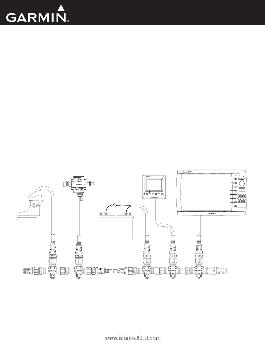
functionality. If your boat already contains a NMEA 2000 network and you would like to add Garmin NMEA 2000 components, see page 8. For a glossary of commonly used NMEA 2000 terms, 2000 network on your boat, this guide will help you assemble one. Technical Reference for Garmin NMEA 2000 Products 1 - Garmin GPSMAP 527 | Technical Reference for Garmin NMEA 2000 Products - Page 6
are used to create custom-length drop cables and custom-length backbone extension cables. The field-installable connectors can be used to shorten any Garmin NMEA 2000 drop/backbone cable. ** The gray in-line lightning arrestor is designed to help prevent damage due to nearby lightning strikes, but - Garmin GPSMAP 527 | Technical Reference for Garmin NMEA 2000 Products - Page 7
the NMEA 2000 network; others may require a separate power connection. Consult the installation instructions for each device you connect to your NMEA 2000 network to be sure you supply (page 7) • Cable length and device limits (page 8) Technical Reference for Garmin NMEA 2000 Products 3 - Garmin GPSMAP 527 | Technical Reference for Garmin NMEA 2000 Products - Page 8
installed incorrectly) Correct Linear Backbone Construction To NMEA 2000 devices and power INCORRECT Backbone extension cable Male terminator Incorrect Linear Backbone Construction 4 Technical Reference for Garmin NMEA 2000 Products - Garmin GPSMAP 527 | Technical Reference for Garmin NMEA 2000 Products - Page 9
-drain wire to the same location as the ground (black) wire. The Garmin NMEA 2000 power cable connects to a T-connector like other drop cables. Be battery to the farthest device, in meters) × Network Load** × 0.1 * Garmin cable resistance value = 0.053 ** Network Load = the sum of Load Equivalent - Garmin GPSMAP 527 | Technical Reference for Garmin NMEA 2000 Products - Page 10
load function correctly. Voltage Drop Right = 0.053 × (2 + 10 + 6) × (5 + 7) × 0.1 = 1.145 Vdc Note: The equation and examples provide conservative estimates for calculating voltage drop. 6 Technical Reference for Garmin NMEA 2000 Products - Garmin GPSMAP 527 | Technical Reference for Garmin NMEA 2000 Products - Page 11
final NMEA 2000 device with a female connector. Because of this, you can only use one in-line terminator on a NMEA 2000 network. Technical Reference for Garmin NMEA 2000 Products 7 - Garmin GPSMAP 527 | Technical Reference for Garmin NMEA 2000 Products - Page 12
and cables in the backbone. Mini connectors are larger than micro connectors, and you will need to use a converter or adapter to connect with Garmin NMEA 2000 devices. Power: Is the existing NMEA 2000 network connected to power? A NMEA 2000 network must be connected to power to function correctly - Garmin GPSMAP 527 | Technical Reference for Garmin NMEA 2000 Products - Page 13
2000-certified display devices (such as a GPSMAP 4000/5000 series chartplotter or a GMI 10 Garmin Chartplotter and GPS Antenna Garmin Chartplotter and GPS Antenna Garmin Chartplotter Garmin Chartplotter and GPS Antenna Garmin Chartplotter and GPS Antenna Garmin Chartplotter and GPS Antenna Garmin - Garmin GPSMAP 527 | Technical Reference for Garmin NMEA 2000 Products - Page 14
Sender GPS Antenna 129026 - COG/SOG and 129029 - GNSS Position GPS Antenna 129026 - COG/SOG, 129029 - GNSS Position, and 129284 - Nav Data Garmin Chartplotter and GPS Antenna 129026 - COG/SOG and 129029 - GNSS Position GPS Antenna 129026 - COG/SOG and 129029 - GNSS Position GPS Antenna 129026 - Garmin GPSMAP 527 | Technical Reference for Garmin NMEA 2000 Products - Page 15
- COG/SOG and 129029 - GNSS Position]) Either a Wind Sensor and Speed Sensor or a Wind Sensor and a GPS Antenna Waypoint VMG 129284 - Nav Data Garmin Chartplotter and GPS Antenna Maximum Apparent Wind Speed 130306 - Wind Data Wind Sensor Maximum True Wind Speed 130306 - Wind Data and 128259 - Garmin GPSMAP 527 | Technical Reference for Garmin NMEA 2000 Products - Page 16
Antenna, Water Speed Sensor, and Heading Sensor GPS Antenna, Water Speed Sensor, and Heading Sensor GPS Antenna GPS Antenna None None 12 Technical Reference for Garmin NMEA 2000 Products - Garmin GPSMAP 527 | Technical Reference for Garmin NMEA 2000 Products - Page 17
2000-certified display devices. For NMEA 2000 configuration information on every available Garmin NMEA 2000-certified display device, see the owner's manual for your display device. GPSMAP 6000/7000 Series Chartplotters Receive 059392 ISO Acknowledgment 059904 ISO Request 060928 ISO Address - Garmin GPSMAP 527 | Technical Reference for Garmin NMEA 2000 Products - Page 18
NMEA 2000-Compatible Display Device PGN Information GPSMAP 4000/5000 Series Chartplotters Receive 059392 059904 060928 126208 126464 126992 126996 127250 Error Navigation Data Navigation - Route/Waypoint Information Wind Data Temperature 14 Technical Reference for Garmin NMEA 2000 Products - Garmin GPSMAP 527 | Technical Reference for Garmin NMEA 2000 Products - Page 19
NMEA 2000-Compatible Display Device PGN Information GPSMAP 700 Series Chartplotters Receive 059392 ISO Acknowledgment 059904 ISO Request 060928 ISO Address Claim 126208 - Route/WP information GNSS DOPs GNSS Sats in View Wind Data Technical Reference for Garmin NMEA 2000 Products 15 - Garmin GPSMAP 527 | Technical Reference for Garmin NMEA 2000 Products - Page 20
NMEA 2000-Compatible Display Device PGN Information GPSMAP 4x1/5x1 Series Chartplotters Receive 059392 ISO Acknowledgment 059904 ISO Request 060928 ISO Address Claim 126208 - Route/WP information GNSS DOPs GNSS Sats in View Wind Data 16 Technical Reference for Garmin NMEA 2000 Products - Garmin GPSMAP 527 | Technical Reference for Garmin NMEA 2000 Products - Page 21
126996 ISO Acknowledgment ISO Request ISO Address Claim NMEA - Command/Request/Acknowledge Group Function Transmit/Receive PGN List Group Function Product Information Technical Reference for Garmin NMEA 2000 Products 17 - Garmin GPSMAP 527 | Technical Reference for Garmin NMEA 2000 Products - Page 22
2000-Certified Sensor PGN Information NMEA 2000-Certified Sensor PGN Information The following tables list the non-proprietary PGN information for all Garmin NMEA 2000-certified sensors. GPS 17x (GPS Antenna) Transmit Receive 059392 060928 126208 126464 126992 126996 129025 129026 129029 129539 - Garmin GPSMAP 527 | Technical Reference for Garmin NMEA 2000 Products - Page 23
List Group Function Product Information Engine Parameters - Rapid Update Receive 126208 NMEA - Command/Request/Acknowledge Group Function GFL 10 (Garmin Fluid Level Adapter) Transmit 059392 ISO Acknowledgment 060928 ISO Address Claim 126208 NMEA - Command/Request/Acknowledge Group Function 126464 - Garmin GPSMAP 527 | Technical Reference for Garmin NMEA 2000 Products - Page 24
NMEA 2000-Certified Sensor PGN Information GWS 10 (Garmin Wind Sensor) Transmit 059392 ISO Acknowledgment 060928 ISO Address Claim 126208 NMEA - Command/ Rapid Update GNSS Position Data Navigation Data Navigation - Route/WP information 20 Technical Reference for Garmin NMEA 2000 Products - Garmin GPSMAP 527 | Technical Reference for Garmin NMEA 2000 Products - Page 25
Report AIS Class B Extended Position Report AIS SAR Aircraft Position Report Radio Frequency/Mode/Power Radio Frequency/Mode/Power DSC Call Information Technical Reference for Garmin NMEA 2000 Products 21 - Garmin GPSMAP 527 | Technical Reference for Garmin NMEA 2000 Products - Page 26
Position Report AIS Safety Related Broadcast Message AIS Class B "CS" Static Data Report, Part A AIS Class B "CS" Static Data Report, Part B 22 Technical Reference for Garmin NMEA 2000 Products - Garmin GPSMAP 527 | Technical Reference for Garmin NMEA 2000 Products - Page 27
and Disabling WAAS (Wide Area Augmentation System)/EGNOS (Euro Geostationary Navigation Overlay Service) When enabled, WAAS/EGNOS provides more-accurate position information. For more information on WAAS/EGNOS, visit www.garmin.com. 1. While viewing the NMEA 2000 configuration menu, select the GPS - Garmin GPSMAP 527 | Technical Reference for Garmin NMEA 2000 Products - Page 28
used to calculate fuel economy. Using Fuel-Level Information With a Garmin Chartplotter or Marine Instrument To receive fuel-level information, connect the fuel-level sensor of your boat according to the GFS 10 Installation Instructions. To calibrate fuel-level information from the GFS 10: 1. While - Garmin GPSMAP 527 | Technical Reference for Garmin NMEA 2000 Products - Page 29
Troubleshooting Fuel Gauge Type When wired to a fuel gauge, the gauge type defaults to Auto Detect. If the fuel-level reading on your Garmin setting test. Troubleshooting the Fuel-Flow Reading If the fuel-flow information received from the GFS 10 appears inaccurate, you can manually adjust the fuel - Garmin GPSMAP 527 | Technical Reference for Garmin NMEA 2000 Products - Page 30
most Garmin chartplotters, select Review > Rudder Angle Calibration. • For other Garmin marine devices, select Config > Rudder Angle Calibration. 4. Follow the on-screen instructions to calibrate the starboard and port rudder angles. 5. Select OK when the calibration is complete. Troubleshooting the - Garmin GPSMAP 527 | Technical Reference for Garmin NMEA 2000 Products - Page 31
to. When you troubleshoot the gauge-type setting, if the rudder-angle reading on a connected Garmin chartplotter or marine Garmin chartplotters, select Review > Engine Tilt Calibration. • For other Garmin marine devices, select Config > Engine Tilt Calibration. 4. Follow the on-screen instructions - Garmin GPSMAP 527 | Technical Reference for Garmin NMEA 2000 Products - Page 32
10 device. 2. Select an option: • For most Garmin chartplotters, select Review > Engine Number. • For other Garmin marine devices, select Config > Engine Number. 3. Select the number of the engine that the adapter is associated with. 4. Select Done. Troubleshooting the Gauge Type When connected to - Garmin GPSMAP 527 | Technical Reference for Garmin NMEA 2000 Products - Page 33
connected to. When you troubleshoot the gauge-type setting, if the engine-tilt reading on a connected Garmin chartplotter or marine instrument . 2. Select an option: • For most Garmin chartplotters, select Review > N2K Fluid Type. • For other Garmin marine devices, select Config > N2K Fluid Type - Garmin GPSMAP 527 | Technical Reference for Garmin NMEA 2000 Products - Page 34
list, select the GFL 10 device. 2. Select an option: • For most Garmin chartplotters, select Review > Tank Number. • For other Garmin marine devices, select Config > Tank Number. 3. Select a tank number. 4. Select OK. Troubleshooting the Gauge Type When connected to a gauge, the GFL 10 adapter gauge - Garmin GPSMAP 527 | Technical Reference for Garmin NMEA 2000 Products - Page 35
gauge type: 1. From the NMEA 2000 Devices list, select the GFL 10 device. 2. Select an option: • For most Garmin chartplotters, select Review > Gauge Type. • For other Garmin marine devices, select Config > Gauge Type. 3. Select an option: • To automatically detect the gauge type, select Auto Detect - Garmin GPSMAP 527 | Technical Reference for Garmin NMEA 2000 Products - Page 36
list, select the GBT 10 device. 2. Select an option: • For most Garmin chartplotters, select Review > Trim Tab Calibration. • For other Garmin marine devices, select Config > Trim Tab Calibration. 3. Follow the on-screen instructions to calibrate the trim tab position. Configuring the GBT 10 Adapter - Garmin GPSMAP 527 | Technical Reference for Garmin NMEA 2000 Products - Page 37
select the GST 10 device. 2. Select an option: • For most Garmin chartplotters, select Review > Calibrate Water Speed. • For other Garmin marine devices, select Config > Calibrate Water Speed. 3. Follow the on-screen instructions to calibrate the water speed. Assigning a NMEA 2000 Temperature Source - Garmin GPSMAP 527 | Technical Reference for Garmin NMEA 2000 Products - Page 38
NMEA 2000 Checklist 4. Select Done. Troubleshooting the Sensor Number If multiple GST 10 adapters the GST 10 device. 2. Select an option: • For most Garmin chartplotters, select Review > Generic Config. • For other Garmin marine devices, select Config >Generic Configuration. 3. Ensure that the boat - Garmin GPSMAP 527 | Technical Reference for Garmin NMEA 2000 Products - Page 39
one of the GST 10 devices assigned to the same temperature source. 2. Select an option: • For most Garmin chartplotters, select Review > Generic Config. • For other Garmin marine devices, select Config >Generic Configuration. 3. Enter the following command: "INSTANCE=" 4. After the command, enter - Garmin GPSMAP 527 | Technical Reference for Garmin NMEA 2000 Products - Page 40
negative number to show depth at the surface. Keel Offset GWS 10 (Garmin Wind Sensor) Configuring the Wind Angle Offset (Orientation) When mounting the not orient the GWS 10 as described in the GWS 10 Installation Instructions. To configure the wind angle offset (orientation): 1. While viewing - Garmin GPSMAP 527 | Technical Reference for Garmin NMEA 2000 Products - Page 41
conditions. Configuring the GWS 10 if the Filter and Offset Selections Are Not Displayed Depending on the version of software loaded on your Garmin marine instrument, the specific configuration options may not be displayed on the configuration screens. To configure the wind angle offset if the menu - Garmin GPSMAP 527 | Technical Reference for Garmin NMEA 2000 Products - Page 42
. (6 m)? (page 8) For the latest free software updates (excluding map data) throughout the life of your Garmin products, visit the Garmin Web site at www.garmin.com. March 2012 © 2009-2012 Garmin Ltd. or its subsidiaries Garmin International, Inc. 1200 East 151st Street, Olathe, Kansas 66062, USA
-
 1
1 -
 2
2 -
 3
3 -
 4
4 -
 5
5 -
 6
6 -
 7
7 -
8
-
9
-
10
-
11
-
12
-
13
-
14
-
15
-
16
-
17
-
18
-
19
-
20
-
21
-
22
-
23
-
24
-
25
-
26
-
27
-
28
-
29
-
30
-
31
-
32
-
33
-
34
-
35
-
36
-
37
-
38
-
39
-
40
-
41
-
42
 |
 |
+
-
Technical Reference
for Garmin
®
NMEA 2000
®
Products