Garmin GPSMAP 740/740s Owner's Manual - Page 65
About the Radar Overlay, Cruising, Harbor, Offshore, Sentry, Where To?, Routes, Navigate To, Offset
 |
View all Garmin GPSMAP 740/740s manuals
Add to My Manuals
Save this manual to your list of manuals |
Page 65 highlights
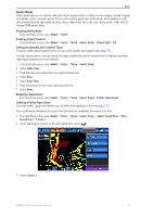
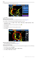
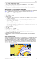
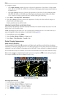
Radar 6. Select Cruising, Harbor, Offshore, or Sentry. The route appears as a magenta line, with the starting point, the destination, and turns indicated. 7. Review the course indicated by the magenta line. 8. Follow the magenta line along each leg in the route, steering to avoid land, shallow water, and other obstacles. Navigating Parallel to a Saved Route on the Radar Screen Before you can browse a list of routes and navigate to one of them, you must record and save at least one route (page 28). Navigation lines must be showing in order to view a route on the Radar screen (page 68). 1. From the Home screen, select Where To? > Routes. 2. Select a route. 3. Select Navigate To > Offset. 4. Complete an action: • Select Forward - Port to navigate the route from the starting point used when the route was created, to the left of the original route. • Select Forward - Starboard to navigate the route from the starting point used when the route was created, to the right of the original route. • Select Backward - Port to navigate the route from the destination point used when the route was created, to the left of the original route. • Select Backward - Starboard to navigate the route from the destination point used when the route was created, to the right of the original route. 5. Enter the offset distance. 6. Select Done. 7. From the Home screen, select Radar. 8. Select Cruising, Harbor, Offshore, or Sentry. The route appears as a magenta line, with the starting point, the destination, and turns indicated. 9. Review the course indicated by the magenta line. 10. Follow the magenta line along each leg in the route, steering to avoid land, shallow water, and other obstacles. About the Radar Overlay The Radar Overlay superimposes radar information on the Navigation chart or the Fishing chart. Data appears on the Radar Overlay based on the most-recently used radar mode (Cruising, Harbor, Offshore, or Sentry), and all settings configurations applied to the Radar Overlay are also applied to the last-used radar mode. For example, if you use Harbor mode and then you switch to the Radar Overlay, the Radar Overlay would show Harbor mode radar data. If you changed the gain setting using the Radar Overlay menu, the gain setting for Harbor mode would change automatically. Radar Overlay on the Navigation Chart GPSMAP 700 Series Owner's Manual 61
-
 1
1 -
2
-
3
-
4
-
5
-
6
-
7
-
8
-
9
-
10
-
11
-
12
-
13
-
14
-
15
-
16
-
17
-
18
-
19
-
20
-
21
-
22
-
23
-
24
-
25
-
26
-
27
-
28
-
29
-
30
-
31
-
32
-
33
-
34
-
35
-
36
-
37
-
38
-
39
-
40
-
41
-
42
-
43
-
44
-
45
-
46
-
47
-
48
-
49
-
50
-
51
-
52
-
53
-
54
-
55
-
56
-
57
-
58
-
59
-
 60
60 -
 61
61 -
 62
62 -
 63
63 -
 64
64 -
 65
65 -
 66
66 -
 67
67 -
 68
68 -
 69
69 -
 70
70 -
71
-
72
-
73
-
74
-
75
-
76
-
77
-
78
-
79
-
80
-
81
-
82
-
83
-
84
-
85
-
86
-
87
-
88
-
89
-
90
-
91
-
92
-
93
-
94
-
95
-
96
-
97
-
98
-
99
-
100
 |
 |