Garmin GPSMAP 740/740s Owner's Manual - Page 74
Charts, Radar Overlay, Setup, Chart Setup, Detail, Heading Line, Distance, Change Distance
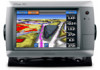 |
View all Garmin GPSMAP 740/740s manuals
Add to My Manuals
Save this manual to your list of manuals |
Page 74 highlights
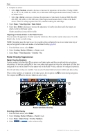
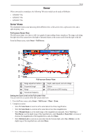
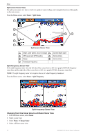
Radar Radar Overlay Navigation Display Settings Changing the Map Zoom Detail You can adjust the amount of detail shown on the map, at different zoom levels, for the Radar Overlay. 1. From the Home screen, select Charts > Radar Overlay > Menu > Setup > Chart Setup > Detail. 2. Select a level of detail. Showing and Configuring the Heading Line The heading line is an extension drawn on the map from the bow of the boat in the direction of travel. You can configure the appearance of the heading line on the Radar Overlay. 1. From the Home screen, select Charts > Radar Overlay > Menu > Setup > Chart Setup > Heading Line. 2. Complete an action: • Select Distance > Change Distance, and enter the distance to the end of the heading line. • Select Time > Change Time, and enter the amount of time until you reach the end of the heading line. 3. Select Done. 70 GPSMAP 700 Series Owner's Manual
-
 1
1 -
2
-
3
-
4
-
5
-
6
-
7
-
8
-
9
-
10
-
11
-
12
-
13
-
14
-
15
-
16
-
17
-
18
-
19
-
20
-
21
-
22
-
23
-
24
-
25
-
26
-
27
-
28
-
29
-
30
-
31
-
32
-
33
-
34
-
35
-
36
-
37
-
38
-
39
-
40
-
41
-
42
-
43
-
44
-
45
-
46
-
47
-
48
-
49
-
50
-
51
-
52
-
53
-
54
-
55
-
56
-
57
-
58
-
59
-
60
-
61
-
62
-
63
-
64
-
65
-
66
-
67
-
68
-
 69
69 -
 70
70 -
 71
71 -
 72
72 -
 73
73 -
 74
74 -
 75
75 -
 76
76 -
 77
77 -
 78
78 -
 79
79 -
80
-
81
-
82
-
83
-
84
-
85
-
86
-
87
-
88
-
89
-
90
-
91
-
92
-
93
-
94
-
95
-
96
-
97
-
98
-
99
-
100
 |
 |