Garmin GPSMAP 8700 Black Box Owners Manual
Garmin GPSMAP 8700 Black Box Manual
 |
View all Garmin GPSMAP 8700 Black Box manuals
Add to My Manuals
Save this manual to your list of manuals |
Garmin GPSMAP 8700 Black Box manual content summary:
- Garmin GPSMAP 8700 Black Box | Owners Manual - Page 1
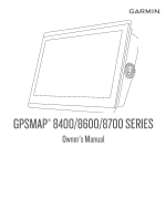
GPSMAP® 8400/8600/8700 SERIES Owner's Manual - Garmin GPSMAP 8700 Black Box | Owners Manual - Page 2
of this manual without obligation to notify any person or organization of such changes or improvements. Go to www.garmin.com for current updates and supplemental information concerning the use of this product. Garmin®, the Garmin logo, ActiveCaptain®, ANT®, BlueChart®, Fusion®, GPSMAP®, inReach - Garmin GPSMAP 8700 Black Box | Owners Manual - Page 3
View (8700 models 2 Tips and Shortcuts (MFD models 2 Tips and Shortcuts (8700 model 2 Accessing Owner's Manuals on the Chartplotter 2 Downloading the Manuals from the Web 2 Garmin Support Center 3 Memory Cards 3 Inserting Memory Cards (10, 12, and 16-inch models 3 Inserting a Memory Card - Garmin GPSMAP 8700 Black Box | Owners Manual - Page 4
Maps Using Garmin Connect 16 Garmin Quickdraw Contours Settings 16 Navigation with a Chartplotter 17 Basic Navigation Questions 17 Destinations 17 Searching for a Destination by Name 17 Selecting a Destination Using the Navigation Chart 17 Searching for a Marine Services Destination 17 - Garmin GPSMAP 8700 Black Box | Owners Manual - Page 5
37 Adjusting Gain on the Radar Screen Manually 37 Minimizing Nearby Large-Object Interference 37 the Helm 40 Adjusting the Heading with the Chartplotter in Step Steering Mode 40 Steering Patterns 40 41 Enabling the Autopilot Controls on a Garmin Watch 41 Customizing the Autopilot Button Actions - Garmin GPSMAP 8700 Black Box | Owners Manual - Page 6
Scales 47 inReach® Messages 48 Connecting an inReach Device to the Chartplotter 48 Receiving inReach Messages 48 Sending an inReach Preset Message 48 Replying Radio ID 51 Activating a SiriusXM Subscription 51 Customizing the Channel Guide 51 Saving a SiriusXM Channel to the Presets List 52 - Garmin GPSMAP 8700 Black Box | Owners Manual - Page 7
a Garmin Chartplotter ....... 58 Troubleshooting 67 My device will not acquire GPS signals 67 My device will not turn on or keeps turning off 67 My device is not creating waypoints in the correct location 67 Contacting Garmin Support 67 Specifications 68 GPSMAP 8x10 Specifications 68 GPSMAP - Garmin GPSMAP 8700 Black Box | Owners Manual - Page 8
- Garmin GPSMAP 8700 Black Box | Owners Manual - Page 9
guide in the product box for product warnings and other important information. All route and navigation lines displayed on the chartplotter The Garmin® website at support.garmin.com presents up-to-date information about your product. The support pages will provide answers to frequently asked support - Garmin GPSMAP 8700 Black Box | Owners Manual - Page 10
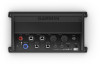
. • When available, select the arrow to open the menu. Tips and Shortcuts (8700 model) • Press on the GPSMAP 8700 device to turn it on and off. You can also turn the device off using a Garmin chartplotter on the network, a GMM™ monitor, or a GRID™ remote. You can put the device to sleep using the - Garmin GPSMAP 8700 Black Box | Owners Manual - Page 11
-8600. 2 Download the manual. Garmin Support Center Go to support.garmin.com for help and information, such as product manuals, frequently asked questions, videos, software updates, and customer support. Memory Cards You can use optional memory cards with the chartplotter. Map cards allow you - Garmin GPSMAP 8700 Black Box | Owners Manual - Page 12
activated (Warning Manager, page 49). When multiple displays are installed on the Garmin Marine Network, you can group them together into a station. A station the Startup Screen You personalize the image that is displayed when the chartplotter is turning on. For the best fit, the image should be 50 - Garmin GPSMAP 8700 Black Box | Owners Manual - Page 13
, select Delete. • To reset all presets to factory settings, select Reset All. Setting the Vessel Type You can select your boat type to configure the chartplotter settings and to use features customized for your boat type. 1 Select Settings > My Vessel > Vessel Type. Customizing the - Garmin GPSMAP 8700 Black Box | Owners Manual - Page 14
NOTICE If you enable the Screen Lock feature, Garmin Support cannot retrieve the PIN or access your device. It and hold to turn off the system manually. 1 Select Settings > System > Auto Power chartplotter display when paired. ActiveCaptain Roles Your level of interaction with the GPSMAP - Garmin GPSMAP 8700 Black Box | Owners Manual - Page 15
> Pair with Chartplotter. 5 Follow the on-screen instructions to pair the app to the GPSMAP device. 6 When garmin.com /express. NOTICE Chart updates may require the app to download large files. Regular data limits or charges from your internet service provider apply. Contact your internet service - Garmin GPSMAP 8700 Black Box | Owners Manual - Page 16
plotters, and then press the pairing key to switch between the chartplotters. 1 Select Settings > Communications > Wireless Devices > Wireless Remotes > GPSMAP® Remote. 2 Select New Connection. 3 Follow the on-screen instructions. Turning On and Off the Remote Backlight Turning off the remote - Garmin GPSMAP 8700 Black Box | Owners Manual - Page 17
Garmin Nautix™ Device You can connect a Garmin Nautix device to the chartplotter to view charplotter data on the Garmin Nautix device. NOTE: You can connect a Garmin detailed charts. Icon Description Buoy Information Marine services Tide station Current station Overhead photo available Perspective - Garmin GPSMAP 8700 Black Box | Owners Manual - Page 18
celestial, chart notes, or local services, about a location or an object use Auto Guidance, select Auto Guidance or . 4 Review the course indicated by the magenta line. NOTE: support all charts. Optional premium charts, such as BlueChart® g3 Vision, allow you to get the most out of your chartplotter - Garmin GPSMAP 8700 Black Box | Owners Manual - Page 19
each vessel includes the Maritime Mobile Service Identity (MMSI), location, GPS speed, GPS heading, time that has elapsed since the last position of the vessel was reported, nearest approach, and time to the nearest approach. Some chartplotter models also support Blue Force Tracking. Vessels being - Garmin GPSMAP 8700 Black Box | Owners Manual - Page 20
Collision Alarm Before you can set a collision alarm, you must have a compatible chartplotter connected to an AIS device or radar. The safe-zone collision alarm is used signal transmission, a distress signal alarm appears. Select Review > Go To to begin navigation to the transmission. 12 Charts - Garmin GPSMAP 8700 Black Box | Owners Manual - Page 21
you to create fishing map labels (Garmin Quickdraw Contours Mapping, page 15). chartplotter models. Some options require premium maps or connected accessories. NOTE: The menus may contain some settings that are not supported navaid type. Service Points: Shows locations for marine services. Depth: - Garmin GPSMAP 8700 Black Box | Owners Manual - Page 22
a wind sensor to the chartplotter. When in sailing mode ( Manual option calculates the laylines using manually may contain some settings that are not supported by your installed charts or your present charts and all bodies of water. Some Garmin LakeVü™ and premium supplemental charts have multiple - Garmin GPSMAP 8700 Black Box | Owners Manual - Page 23
. Supported Maps To help you have a safe and enjoyable time on the water, Garmin devices only support official maps produced by Garmin or When you record data on a memory card in your chartplotter, the new data is added to your existing Garmin Quickdraw Contours map, and is saved on the memory card. - Garmin GPSMAP 8700 Black Box | Owners Manual - Page 24
GPSMAP device, your contour maps are transferred to the community automatically. Connecting to the Garmin Quickdraw Community with Garmin Connect 1 Go to connect.garmin chartplotter automatically recognizes the contours maps. The chartplotter may take a few minutes to load the maps. Garmin Quickdraw - Garmin GPSMAP 8700 Black Box | Owners Manual - Page 25
color of the Garmin Quickdraw Contours display. leg route and navigate it guide me along a straight have premium maps that support Auto Guidance and services. 1 Select Info > Services. 2 Select Offshore Services or Inland Services. 3 If necessary, select the marine service category. The chartplotter - Garmin GPSMAP 8700 Black Box | Owners Manual - Page 26
a proposed turning radius to return your boat to the course. WARNING Review the path for obstacles before negotiating the turn. If the path is OK to navigate to the man overboard location. If you selected OK, the chartplotter sets a direct course back to the location. If you selected another type of - Garmin GPSMAP 8700 Black Box | Owners Manual - Page 27
destination. The corrected course is dynamic, and it moves with your boat when you are off course. 5 Review the course indicated by the magenta line. 6 Follow the magenta line along each leg in the route, steering left of the original route, select Backward - Port. Navigation with a Chartplotter 19 - Garmin GPSMAP 8700 Black Box | Owners Manual - Page 28
plot the best path to your destination. Auto Guidance uses your chartplotter to scan chart data, such as water depth and known obstacles, the path near a hazard, select Hazard Review. • To adjust the path, select Adjust Path, and follow the onscreen instructions. • To delete the path, select Cancel - Garmin GPSMAP 8700 Black Box | Owners Manual - Page 29
Not all settings apply to all maps. You can set the parameters the chartplotter uses when calculating an Auto Guidance path. Preferred Depth: Sets the minimum water > Near. 7 If you selected Near or Far in step 6, review the placement of the Auto Guidance line, and determine whether the line safely - Garmin GPSMAP 8700 Black Box | Owners Manual - Page 30
destination point used when the track was created, select Backward. 5 Review the course indicated by the colored line. 6 Follow the line Boundaries > New. 2 Select a boundary shape. 3 Follow the on-screen instructions. Converting a Route to a Boundary Before you can convert a route to Chartplotter - Garmin GPSMAP 8700 Black Box | Owners Manual - Page 31
> Boundaries. 2 Select a boundary. 3 Select Review > Edit Boundary > Delete. Deleting All Saved Waypoints features, you must connect a wind sensor to the chartplotter. When in sailing mode (Setting the Vessel Type, sensor. The Manual option calculates the laylines using manually entered windward and - Garmin GPSMAP 8700 Black Box | Owners Manual - Page 32
action: • If the transducer is connected to the chartplotter or a sonar module, select Settings > My Vessel Device List, select the transducer, and select Review > Keel Offset. 3 Select if the transducer autopilot configuration, see the installation instructions included with your autopilot. 1 From - Garmin GPSMAP 8700 Black Box | Owners Manual - Page 33
Enabling the Gybe Inhibitor NOTE: The gybe inhibitor does not prevent you from manually performing a gybe using the helm or step steering. The gybe inhibitor prevents chartplotter can be used as a fishfinder. Chartplotter models without an xsv or xs in their names require a Garmin sounder module - Garmin GPSMAP 8700 Black Box | Owners Manual - Page 34
is beneath the boat. SideVü Sonar View NOTE: Not all models provide built-in SideVü sonar support. If your model does not provide built-in SideVü sonar, you need a compatible sounder module and compatible SideVü transducer. If your model does provide built-in SideVü sonar, you need a compatible - Garmin GPSMAP 8700 Black Box | Owners Manual - Page 35
Drop shot rig Bottom LiveVü Forward Sonar View This sonar view shows a two-dimensional view of what is in front of the boat and can be used to see a bait ball and fish. Color legend Boat Sonar beam Range Fish Bottom RealVü 3D Historical Sonar View This sonar view provides a three-dimensional view - Garmin GPSMAP 8700 Black Box | Owners Manual - Page 36
Model. NOTE: If you select the transducer manually, disconnect that transducer, and then connect a chartplotters and transducers are mounted on your boat. For example, from one GPSMAP 8417 device mounted at the back of the boat, you can view the sonar data from another GPSMAP device and Garmin - Garmin GPSMAP 8700 Black Box | Owners Manual - Page 37
Recordings. 3 Select a recording. 4 Select Review > Delete. Playing Sonar Recordings Before you can Garmin ClearVü, and SideVü Sonar Setup NOTE: Not all options and settings apply to all models, sounder the depth range of the magnified area manually, select Manual. If necessary, select Set Zoom to - Garmin GPSMAP 8700 Black Box | Owners Manual - Page 38
range of the depth scale traditional and Garmin ClearVü sonar views and the range of To allow the chartplotter to adjust the range automatically, select Auto. • To increase or decrease the range manually, select Up or sounder data received. This is especially helpful when you are using the sounder in - Garmin GPSMAP 8700 Black Box | Owners Manual - Page 39
for the bottom. The device will not search for the bottom deeper than the selected depth. Traditional, Garmin ClearVü, and SideVü Transducer Installation Settings From a Traditional, Garmin ClearVü, or SideVü sonar view, select Menu > Sonar Setup > Installation. Transmit Rate: Sets the length of - Garmin GPSMAP 8700 Black Box | Owners Manual - Page 40
Range: Adjusts the range of the forward scale. Allowing the device to adjust the range automatically adjusts the forward scale in relation to the depth. Manually adjusting the range enables you to view a specified range. The bottom can appear on the screen as long as it appears within the range you - Garmin GPSMAP 8700 Black Box | Owners Manual - Page 41
for the bottom. Bottom Style: Sets the style for the bottom. When you are in deep water, you can select the Points option and manually set the range to a shallower value. Color Key: Shows a legend of the depths the colors represent. Perspective Appearance Settings the Perspective sonar view, select - Garmin GPSMAP 8700 Black Box | Owners Manual - Page 42
sensor. 3 Select Calibrate Compass. 4 Follow the on-screen instructions. Radar WARNING The marine radar transmits microwave energy that has the radar screen. Land Vessel Radar Overlay When you connect your chartplotter to an optional Garmin marine radar, you can use overlay radar information on the - Garmin GPSMAP 8700 Black Box | Owners Manual - Page 43
1 With the chartplotter off, connect your radar as described in the radar installation instructions. 2 Turn on the chartplotter. If necessary, radar models support two notransmit zones. Most other GMR radar models support one notransmit zone. GMR 18 HD+ radar models do not support notransmit zones - Garmin GPSMAP 8700 Black Box | Owners Manual - Page 44
, nearest approach, and time to nearest approach. MARPA indicates the status of each tagged object (acquiring, lost, tracking, or dangerous), and the chartplotter can sound a collision alarm if the object enters your safe zone. Before you can use MARPA, you must have a heading sensor connected and - Garmin GPSMAP 8700 Black Box | Owners Manual - Page 45
NOTE: Not all options and settings are available on all radar and chartplotter models. NOTE: You can optimize the radar display for each radar screen is refreshed every few seconds. As a result, the effects of manually adjusting the gain may not appear instantly. Adjust the gain slowly. 3 Select - Garmin GPSMAP 8700 Black Box | Owners Manual - Page 46
a setting that reflects the present sea conditions. Clutter caused by sea conditions may still be visible. When using a compatible radar model, the chartplotter adjusts the sea clutter based on the sea conditions automatically. Adjusting Rain Clutter on the Radar Screen You can adjust the appearance - Garmin GPSMAP 8700 Black Box | Owners Manual - Page 47
of your boat to maintain a constant heading (heading hold). The system also allows manual steering and several modes of automaticsteering functions and patterns. Autopilot When the chartplotter is connected to a compatible Garmin autopilot system, you can engage and control the autopilot from the - Garmin GPSMAP 8700 Black Box | Owners Manual - Page 48
. The autopilot activates Shadow Drive mode. When you release the helm and manually maintain a specific heading for a few seconds, the autopilot resumes a heading hold at the new heading. Adjusting the Heading with the Chartplotter in Step Steering Mode Before you can steer your boat using the keys - Garmin GPSMAP 8700 Black Box | Owners Manual - Page 49
the Reactor autopilot remote control instructions at garmin.com Pairing a Reactor Autopilot Remote Control With a Chartplotter 1 Select Settings > never leave the helm unattended. Always be prepared to promptly regain manual control of your boat. Learn to operate the autopilot on calm - Garmin GPSMAP 8700 Black Box | Owners Manual - Page 50
. Always disconnect the motor from the battery before cleaning or servicing the propeller to avoid injury. You are responsible for the chartplotter to view and control the motor using the chartplotter. Connecting to a Trolling Motor You can connect the chartplotter wirelessly to a compatible Garmin - Garmin GPSMAP 8700 Black Box | Owners Manual - Page 51
Compass Cal.. 3 Follow the on-screen instructions. Setting the Bow Offset Based on the Manual setting, the propeller turns off when the boat reaches the end of the route. CAUTION When using the Manual Garmin VHF radio. • When you initiate a man-overboard distress call from your radio, the chartplotter - Garmin GPSMAP 8700 Black Box | Owners Manual - Page 52
must be connected to a VHF radio that supports DSC. Select Info > DSC List. Adding a DSC Contact You can add a vessel to your DSC list. You can make calls to a DSC contact from the chartplotter. 1 Select Info > DSC List > Add Contact. 2 Enter the Maritime Mobile Service Identity (MMSI) of the vessel - Garmin GPSMAP 8700 Black Box | Owners Manual - Page 53
Review > Call with Radio. 4 If necessary, select Channel, and select a new channel. 5 Select Send. The chartplotter sends information about the call to the radio. 6 On your Garmin how the engines are shown in the gauges, you must manually select the number of engines (Selecting the Number of Engines - Garmin GPSMAP 8700 Black Box | Owners Manual - Page 54
the problem the engine manual to the on-screen instructions to calibrate the trouble codes for the active engine alarms. Provide this information to the Yamaha dealer. Setting the Fuel Alarm Before you can set a fuel level alarm, a compatible fuel flow sensor must be connected to the chartplotter - Garmin GPSMAP 8700 Black Box | Owners Manual - Page 55
combined total capacity of the fuel tanks. Synchronizing the Fuel Data with the Actual Vessel Fuel You can synchronize the fuel levels in the chartplotter with the actual fuel in the vessel when you add fuel to your vessel. 1 Select OneHelm™, A/V, Gauges > Engines > Menu. 2 Select an option: • After - Garmin GPSMAP 8700 Black Box | Owners Manual - Page 56
chartplotter connect automatically when they are within range. Receiving inReach Messages When your inReach device receives a message, a pop-up notification appears briefly on the GPSMAP screen. • To review the full message, select Review with information, instructions, and alerts about - Garmin GPSMAP 8700 Black Box | Owners Manual - Page 57
Proceed with extreme caution. Read the Optimus owner's manual and always wear a personal flotation device (PFD). Manager. 2 Select a message. 3 Select Review. Sorting and Filtering Messages 1 Select Info > Garmin Marine Network, you can control the stereo using the chartplotter. The chartplotter - Garmin GPSMAP 8700 Black Box | Owners Manual - Page 58
The Source button only appears for devices that support multiple media sources. Playing Music Browsing for PartyBus stereo must be connected to the chartplotter using the NMEA 2000 network. NOTE: For instructions on connecting a DAB adapter and antenna, see the installation instructions provided - Garmin GPSMAP 8700 Black Box | Owners Manual - Page 59
back of its packaging, or by tuning your chartplotter to channel 0. 1 Select Media > Source the SiriusXM signal. 5 If the service is not activated within the hour, Guide SiriusXM radio channels are grouped in categories. You can select the categories of channels that appear in the channel guide - Garmin GPSMAP 8700 Black Box | Owners Manual - Page 60
ARC label on the HDMI connector that supports ARC. NOTE: The Fusion MS-AV750 stereo supports ARC. You should update the stereo to use ARC with the chartplotter. SiriusXM Weather WARNING The weather information provided through this product is subject to service interruptions and may contain errors - Garmin GPSMAP 8700 Black Box | Owners Manual - Page 61
Data Broadcasts Weather data is broadcast at different intervals for each weather feature. For example, radar is broadcast at five-minute intervals. When the Garmin receiver is turned on, or when a different weather feature is selected, the receiver must receive new data before it can be shown. You - Garmin GPSMAP 8700 Black Box | Owners Manual - Page 62
: • To allow the chartplotter to adjust the temperature range automatically, select Auto Configure. The chartplotter automatically finds the lower and an option: • To view present weather conditions from a local weather service, select Current Condition. • To view a local weather forecast, select - Garmin GPSMAP 8700 Black Box | Owners Manual - Page 63
services you have subscribed to and how many minutes have passed since the data for each service ports on the chartplotter or to the Garmin Marine Network, as well as supported network (IP-based available on all camera models and chartplotter models. Refer to the camera manual for a list of available - Garmin GPSMAP 8700 Black Box | Owners Manual - Page 64
supports gesture responses, you can control pan-tilt-zoom cameras using gestures directly on the chartplotter screen. Check your camera user manual , or Auto. • To allow the chartplotter to automatically select the source format, select Standard > Auto. Garmin VIRB® Action Cameras WARNING Do not view - Garmin GPSMAP 8700 Black Box | Owners Manual - Page 65
open the full screen view of the VIRB action camera. HDMI Video Considerations NOTICE To prevent corrosion due to moisture, you must use Garmin GPSMAP accessory cables when connecting the chartplotter to the video source or display. Do not connect a media player stick directly into the back of the - Garmin GPSMAP 8700 Black Box | Owners Manual - Page 66
) on the MFD chartplotter screen, but not on an external screen. You cannot view any HDCP content on a screen connected to the GPSMAP 8700 black box. Check the video source's manual to verify that HDCP can be turned off for the source. HDMI video is shared across the Garmin Marine Network, but - Garmin GPSMAP 8700 Black Box | Owners Manual - Page 67
supplemental map information (if applicable), the software version for an optional Garmin radar (if applicable), and the unit ID number. You may of labels shown with route turns on the map. Turn Transition: Adjusts how the chartplotter transitions to the next turn or leg or the route. You can set the - Garmin GPSMAP 8700 Black Box | Owners Manual - Page 68
you selected Near or Far in step 6, review the placement of the Auto Guidance line, and chartplotter to external NMEA 0183 devices, a computer, or other Garmin devices. 1 Select Settings > Communications > NMEA 0183 Setup > Port Types. 2 Select an input or output port. 3 Select a format: • To support - Garmin GPSMAP 8700 Black Box | Owners Manual - Page 69
from the list on the left. 4 Select Review > Change Name. 5 Enter the name, and select Done. Marine Network The Marine Network allows you to share data from Garmin peripheral devices with the chartplotters quickly and easily. You can connect a chartplotter to the Marine Network to receive data from - Garmin GPSMAP 8700 Black Box | Owners Manual - Page 70
Device List, select the transducer, and select Review > Calibrate Water Speed. 2 Follow the on-screen instructions. If the boat is not moving fast to get the message, contact Garmin product support. 2 Complete an action: • If the transducer is connected to the chartplotter or a sonar module, select - Garmin GPSMAP 8700 Black Box | Owners Manual - Page 71
data across the Garmin Marine Network. • You can share and manage user data using a memory card. You must have a memory card installed in the device. This device supports up to a 32 GB memory card, formatted to FAT32. Copying Waypoints, Routes, and Tracks from HomePort to a Chartplotter Before you - Garmin GPSMAP 8700 Black Box | Owners Manual - Page 72
system information to a memory card as a troubleshooting tool. A product support representative may ask you to use this information to retrieve data about the network. 1 Insert a memory card into the card slot. 2 Select Settings > System > System Information > Garmin Devices > Save to Card. 3 If - Garmin GPSMAP 8700 Black Box | Owners Manual - Page 73
into the card slot on the computer. 2 Go to garmin.com/support/software/marine.html. TIP: You can also download updated owner's manuals to load on the chartplotter from this web page. 3 Select GPSMAP Series with SD Card. 4 Select Download next to GPSMAP Series with SD Card. 5 Read and agree to the - Garmin GPSMAP 8700 Black Box | Owners Manual - Page 74
(8700 Model) NOTICE To prevent corrosion due to moisture, you must use Garmin GPSMAP accessory cables when connecting the chartplotter to the computer. Using different cables voids your warranty. You can connect the chartplotter to a computer to see the computer screen and to control the computer - Garmin GPSMAP 8700 Black Box | Owners Manual - Page 75
the memory card from the chartplotter, and insert it into a card reader that is attached to a computer. 2 From Windows Explorer, open the Garmin\scrn folder on the memory card. 3 Copy a .bmp file from the card and paste it to any location on the computer. Troubleshooting My device will not acquire - Garmin GPSMAP 8700 Black Box | Owners Manual - Page 76
size Wi‑Fi and ANT technologies 2.4 GHz @ 12.3 dBm nominal Compatible with OneHelm integration GPSMAP 8x16 Specifications Dimensions (W × H × D) Display size (W × H) 38.5 × 26 for up to 30 min. For more information, go to www.garmin.com/waterrating. Fuse 10 A, 125 V fast-acting Input voltage - Garmin GPSMAP 8700 Black Box | Owners Manual - Page 77
m for up to 30 min. For more information, go to www.garmin.com/waterrating. Fuse 15 A Input voltage From 10 to 35 Vdc and Bluetooth technologies 2.4 GHz @ 9.87 dBm nominal Compatible with OneHelm integration GPSMAP 8700 Specifications Dimensions (W × H × D) Clearance on front of device Weight - Garmin GPSMAP 8700 Black Box | Owners Manual - Page 78
060 to 1,170 kHz Sonar transmit power CHIRP: 1000 W (RMS)2 Garmin ClearVü and SideVü CHIRP: 500 W Sonar depth3 5,000 ft. Information The chartplotter can receive J1939 sentences. The chartplotter cannot auxiliary coolant 65172 Active diagnostic trouble codes 65226 Vehicle distance 65248 - Garmin GPSMAP 8700 Black Box | Owners Manual - Page 79
Description Engine coolant temperature Engine coolant level Engine fuel rate Engine average fuel economy Engine intake manifold #1 pressure Battery potential / power input 1 Transmission oil temperature Transmission oil pressure Fuel level Engine oil filter differential pressure PGN SPN 65263 110 - Garmin GPSMAP 8700 Black Box | Owners Manual - Page 80
synchronizing with actual fuel 47 Fusion PartyBus 50 G Garmin ClearVü 25 Garmin Marine Network 61 Garmin product support. See product support gauges 45, 46 engine 45 fuel 45, 47 overboard 18, 40, 44 manual viewer 2 maps 15, 64. See charts marine services 17 mark location 18 MARPA acquiring 36 Index - Garmin GPSMAP 8700 Black Box | Owners Manual - Page 81
9, 11, 17, 54 ATONs 12 marine service points 17 MARPA 14 radar overlay 34 vessel trails DAB 51 product registration 64 product support 3, 67 Q quickdraw 16 Index FrontVü 27 gain 28 Garmin ClearVü 25 interference 30 troubleshooting 67 U unit ID 59 units of measure 59 unlocking, screen - Garmin GPSMAP 8700 Black Box | Owners Manual - Page 82
updating charts 7 software 7 user data, deleting 23 V vessel trails 14, 44 VHF radio 43 calling an AIS target 45 distress calls 44 DSC channel 44 individual routine call 44, 45 video 55-58 configuring 55, 56, 58 source 55, 56 viewing 55, 56 VIRB camera 57 voltage 61 VRM 36 measuring 36 showing 36 W - Garmin GPSMAP 8700 Black Box | Owners Manual - Page 83
- Garmin GPSMAP 8700 Black Box | Owners Manual - Page 84
support.garmin.com July 2020 GUID-25CCEC48-337E-47C0-8B89-5C35CCDB65AC v15
-
 1
1 -
 2
2 -
 3
3 -
 4
4 -
 5
5 -
 6
6 -
 7
7 -
8
-
9
-
10
-
11
-
12
-
13
-
14
-
15
-
16
-
17
-
18
-
19
-
20
-
21
-
22
-
23
-
24
-
25
-
26
-
27
-
28
-
29
-
30
-
31
-
32
-
33
-
34
-
35
-
36
-
37
-
38
-
39
-
40
-
41
-
42
-
43
-
44
-
45
-
46
-
47
-
48
-
49
-
50
-
51
-
52
-
53
-
54
-
55
-
56
-
57
-
58
-
59
-
60
-
61
-
62
-
63
-
64
-
65
-
66
-
67
-
68
-
69
-
70
-
71
-
72
-
73
-
74
-
75
-
76
-
77
-
78
-
79
-
80
-
81
-
82
-
83
-
84
 |
 |

GPSMAP
®
8400/8600/8700
SERIES
Owner’s Manual