Garmin GTN 650 Pilot's Guide - Page 186
Terrain Awareness and Warning System, TAWS-B Optional
 |
View all Garmin GTN 650 manuals
Add to My Manuals
Save this manual to your list of manuals |
Page 186 highlights
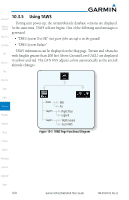
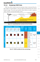
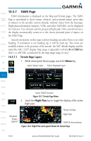
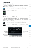
Foreword 10.3 Terrain Awareness and Warning System (TAWS-B) Optional Getting Started TAWS (Terrain Awareness and Warning System) is an optional feature to Xpdr Ctrl increase situational awareness and aid in reducing controlled flight into terrain (CFIT). TAWS provides visual and aural annunciations when terrain and Com/Nav obstacles are within the given altitude threshold from the aircraft. TAWS satisfies TSO-C151b Class B requirements for certification. Class B FPL TAWS is required for all Part 91 turbine aircraft operations with six or more passenger seats and for Part 135 turbine aircraft operations with six to nine Direct-To passenger seats (FAR Parts 91.223, 135.154). Proc 10.3.1 TAWS-B Requirements Wpt Info TAWS requires the following to operate properly: • A valid terrain/obstacle database Map • A valid 3-D GPS position solution Traffic 10.3.2 TAWS-B Limitations Terrain Weather NOTE: The data contained in the TAWS databases comes from government agencies. Garmin accurately processes and cross-validates the data but cannot guarantee the accuracy and completeness of the data. TAWS displays terrain and obstructions relative to the altitude of the aircraft. Nearest Compliance with TAWS B alerts and warnings is MANDATORY. When a TAWS Music B "pull up" annunciation is issued, the pilot is required to pull up. TAWS uses terrain and obstacle information supplied by government sources. Utilities Terrain information is based on terrain elevation information in a database that may contain inaccuracies. Individual obstructions may be shown if available in System the database. The data undergoes verification by Garmin to confirm accuracy of the content, per TSO-C151b. Messages Symbols Appendix Index 10-6 Garmin GTN 625/635/650 Pilot's Guide 190-01004-03 Rev. B
-
 1
1 -
2
-
3
-
4
-
5
-
6
-
7
-
8
-
9
-
10
-
11
-
12
-
13
-
14
-
15
-
16
-
17
-
18
-
19
-
20
-
21
-
22
-
23
-
24
-
25
-
26
-
27
-
28
-
29
-
30
-
31
-
32
-
33
-
34
-
35
-
36
-
37
-
38
-
39
-
40
-
41
-
42
-
43
-
44
-
45
-
46
-
47
-
48
-
49
-
50
-
51
-
52
-
53
-
54
-
55
-
56
-
57
-
58
-
59
-
60
-
61
-
62
-
63
-
64
-
65
-
66
-
67
-
68
-
69
-
70
-
71
-
72
-
73
-
74
-
75
-
76
-
77
-
78
-
79
-
80
-
81
-
82
-
83
-
84
-
85
-
86
-
87
-
88
-
89
-
90
-
91
-
92
-
93
-
94
-
95
-
96
-
97
-
98
-
99
-
100
-
101
-
102
-
103
-
104
-
105
-
106
-
107
-
108
-
109
-
110
-
111
-
112
-
113
-
114
-
115
-
116
-
117
-
118
-
119
-
120
-
121
-
122
-
123
-
124
-
125
-
126
-
127
-
128
-
129
-
130
-
131
-
132
-
133
-
134
-
135
-
136
-
137
-
138
-
139
-
140
-
141
-
142
-
143
-
144
-
145
-
146
-
147
-
148
-
149
-
150
-
151
-
152
-
153
-
154
-
155
-
156
-
157
-
158
-
159
-
160
-
161
-
162
-
163
-
164
-
165
-
166
-
167
-
168
-
169
-
170
-
171
-
172
-
173
-
174
-
175
-
176
-
177
-
178
-
179
-
180
-
 181
181 -
 182
182 -
 183
183 -
 184
184 -
 185
185 -
 186
186 -
 187
187 -
 188
188 -
 189
189 -
 190
190 -
 191
191 -
192
-
193
-
194
-
195
-
196
-
197
-
198
-
199
-
200
-
201
-
202
-
203
-
204
-
205
-
206
-
207
-
208
-
209
-
210
-
211
-
212
-
213
-
214
-
215
-
216
-
217
-
218
-
219
-
220
-
221
-
222
-
223
-
224
-
225
-
226
-
227
-
228
-
229
-
230
-
231
-
232
-
233
-
234
-
235
-
236
-
237
-
238
-
239
-
240
-
241
-
242
-
243
-
244
-
245
-
246
-
247
-
248
-
249
-
250
-
251
-
252
-
253
-
254
-
255
-
256
-
257
-
258
-
259
-
260
-
261
-
262
-
263
-
264
-
265
-
266
-
267
-
268
-
269
-
270
-
271
-
272
-
273
-
274
-
275
-
276
-
277
-
278
-
279
-
280
-
281
-
282
-
283
-
284
-
285
-
286
-
287
-
288
-
289
-
290
-
291
-
292
-
293
-
294
-
295
-
296
-
297
-
298
-
299
-
300
-
301
-
302
-
303
-
304
-
305
-
306
-
307
-
308
-
309
-
310
-
311
-
312
-
313
-
314
-
315
-
316
-
317
-
318
-
319
-
320
-
321
-
322
-
323
-
324
-
325
-
326
-
327
-
328
-
329
-
330
-
331
-
332
-
333
-
334
-
335
-
336
-
337
-
338
-
339
-
340
-
341
-
342
-
343
-
344
-
345
-
346
-
347
-
348
-
349
-
350
-
351
-
352
-
353
-
354
-
355
-
356
 |
 |