Garmin GTN 650 Pilot's Guide - Page 21
Getting Started - transponder requirements for
 |
View all Garmin GTN 650 manuals
Add to My Manuals
Save this manual to your list of manuals |
Page 21 highlights
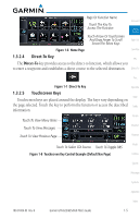
1 Getting Started Foreword 1.1 Model Descriptions Getting Started This guide covers the operation of the GTN 625, 635, and 650. In general, all models will be referred to as the GTN 6XX, except where there are physical or Xpdr Ctrl operational differences. The GTN 6XX units are approximately 6.25 inches wide and 2.65 inches high. The display is a 600 by 266 pixel, 4.9 inch diagonal color Com/Nav LCD with touchscreen controls. The units include one removable SD data card for the databases and software upgrades. FPL The GTN 6XX simplifies your workload with an easy-to-use touch panel that Direct-To provides a visual display of both controls and functions. The required controls are displayed for the selected function. Keys on the display allow you to access Proc and control their functions by a simple touch on the interactive display. The GTN 6XX can integrate a variety of avionics that will not only simplify Wpt Info operation, but also save panel space. The GTN 625, 635, and 650 have their Map own GPS/SBAS navigator and flight planning functions. The GTN 635 adds a VHF Com radio, while the 650 adds VHF Com and VHF Nav radios. Selected Traffic optional external equipment allows you to display and control active traffic systems, XM Entertainment Radio, XM Weather, audio panel, and a Mode S Terrain transponder directly from the GTN 6XX display, and more. 1.1.1 GTN 625 Weather The GTN 625 has a GPS/SBAS engine and is TSO-C146c certified for Nearest primary domestic, oceanic, and remote navigation including en route, terminal, and non-precision approaches, and approaches with vertical guidance, such Music as LPV and LNAV/VNAV. The GTN 625 can simultaneously give aviators vital approach information and weather and traffic data in relation to their position Utilities on a large, color moving map display. Thanks to a high-contrast color display, System the information can be easily read from wide viewing angles even in direct sunlight. Its color moving map features a built-in database that shows cities, Messages highways, railroads, rivers, lakes, coastlines, and a complete Jeppesen database. The Jeppesen database (that can be updated with a front-loading data card) Symbols contains all airports, VORs, NDBs, Intersections, FSSs, Approaches, DPs/STARs, and SUA information. Appendix Index 190-01004-03 Rev. B Garmin GTN 625/635/650 Pilot's Guide 1-1
-
 1
1 -
2
-
3
-
4
-
5
-
6
-
7
-
8
-
9
-
10
-
11
-
12
-
13
-
14
-
15
-
 16
16 -
 17
17 -
 18
18 -
 19
19 -
 20
20 -
 21
21 -
 22
22 -
 23
23 -
 24
24 -
 25
25 -
 26
26 -
27
-
28
-
29
-
30
-
31
-
32
-
33
-
34
-
35
-
36
-
37
-
38
-
39
-
40
-
41
-
42
-
43
-
44
-
45
-
46
-
47
-
48
-
49
-
50
-
51
-
52
-
53
-
54
-
55
-
56
-
57
-
58
-
59
-
60
-
61
-
62
-
63
-
64
-
65
-
66
-
67
-
68
-
69
-
70
-
71
-
72
-
73
-
74
-
75
-
76
-
77
-
78
-
79
-
80
-
81
-
82
-
83
-
84
-
85
-
86
-
87
-
88
-
89
-
90
-
91
-
92
-
93
-
94
-
95
-
96
-
97
-
98
-
99
-
100
-
101
-
102
-
103
-
104
-
105
-
106
-
107
-
108
-
109
-
110
-
111
-
112
-
113
-
114
-
115
-
116
-
117
-
118
-
119
-
120
-
121
-
122
-
123
-
124
-
125
-
126
-
127
-
128
-
129
-
130
-
131
-
132
-
133
-
134
-
135
-
136
-
137
-
138
-
139
-
140
-
141
-
142
-
143
-
144
-
145
-
146
-
147
-
148
-
149
-
150
-
151
-
152
-
153
-
154
-
155
-
156
-
157
-
158
-
159
-
160
-
161
-
162
-
163
-
164
-
165
-
166
-
167
-
168
-
169
-
170
-
171
-
172
-
173
-
174
-
175
-
176
-
177
-
178
-
179
-
180
-
181
-
182
-
183
-
184
-
185
-
186
-
187
-
188
-
189
-
190
-
191
-
192
-
193
-
194
-
195
-
196
-
197
-
198
-
199
-
200
-
201
-
202
-
203
-
204
-
205
-
206
-
207
-
208
-
209
-
210
-
211
-
212
-
213
-
214
-
215
-
216
-
217
-
218
-
219
-
220
-
221
-
222
-
223
-
224
-
225
-
226
-
227
-
228
-
229
-
230
-
231
-
232
-
233
-
234
-
235
-
236
-
237
-
238
-
239
-
240
-
241
-
242
-
243
-
244
-
245
-
246
-
247
-
248
-
249
-
250
-
251
-
252
-
253
-
254
-
255
-
256
-
257
-
258
-
259
-
260
-
261
-
262
-
263
-
264
-
265
-
266
-
267
-
268
-
269
-
270
-
271
-
272
-
273
-
274
-
275
-
276
-
277
-
278
-
279
-
280
-
281
-
282
-
283
-
284
-
285
-
286
-
287
-
288
-
289
-
290
-
291
-
292
-
293
-
294
-
295
-
296
-
297
-
298
-
299
-
300
-
301
-
302
-
303
-
304
-
305
-
306
-
307
-
308
-
309
-
310
-
311
-
312
-
313
-
314
-
315
-
316
-
317
-
318
-
319
-
320
-
321
-
322
-
323
-
324
-
325
-
326
-
327
-
328
-
329
-
330
-
331
-
332
-
333
-
334
-
335
-
336
-
337
-
338
-
339
-
340
-
341
-
342
-
343
-
344
-
345
-
346
-
347
-
348
-
349
-
350
-
351
-
352
-
353
-
354
-
355
-
356
 |
 |