Garmin GTN 650 Pilot's Guide - Page 287
Horizontal of Merit HFOM, Vertical of Merit VFOM, - trainer
 |
View all Garmin GTN 650 manuals
Add to My Manuals
Save this manual to your list of manuals |
Page 287 highlights
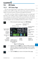
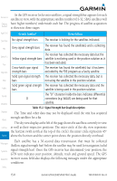
GPS Signal Message Acquiring 3D Nav 3D Diff Nav LOI Description The GPS receiver is acquiring satellites for navigation. In this mode, the receiver uses satellite orbital data (collected continuously from the satellites) and last known position to determine the satellites that should be in view. The GPS receiver is in 3D navigation mode and computes altitude using satellite data. The GPS receiver is in 3D navigation mode and differential corrections are being used. The "LOI" (Loss Of Integrity) annunciator (bottom left corner of the screen) indicates that satellite coverage is insufficient to pass built-in integrity monitoring tests. Foreword Getting Started Xpdr Ctrl Com/Nav FPL Direct-To Proc Wpt Info Table 15-3 GPS Signal Messages Map The GPS Status Page also indicates the accuracy of the position fix, using Horizontal Figure of Merit (HFOM), Vertical Figure of Merit (VFOM), and Traffic Estimated Position Uncertainty (EPU). HFOM and VFOM represent the 95% confidence levels in horizontal and vertical accuracy. The lowest numbers are Terrain the best accuracy and the highest numbers are worse. EPU is the horizontal position error estimated by the Fault Detection and Exclusion (FDE) algorithm, Weather in feet or meters. Nearest NOTE: Operating outside of an SBAS service area with SBAS enabled may cause elevated EPU values to be displayed on the satellite status Music page. Regardless of the EPU value displayed, the LOI annunciation is the controlling indication for determining the integrity of the GPS navigation Utilities solution. System NOTE: The FDE Prediction program is used to predict FDE availability. This program must be used prior to all oceanic or remote area flights for all operators using the GTN as a primary means of navigation under FAR Messages parts 91, 121, 125, and 135. The FDE program is part of the GTN trainer, available for download from the GTN product information page on Garmin's Symbols web site, www.garmin.com. Appendix If the GTN has not been operated for a period of six months or more, acquiring satellite data to establish almanac and satellite orbit information can Index 190-01004-03 Rev. B Garmin GTN 625/635/650 Pilot's Guide 15-9
-
 1
1 -
2
-
3
-
4
-
5
-
6
-
7
-
8
-
9
-
10
-
11
-
12
-
13
-
14
-
15
-
16
-
17
-
18
-
19
-
20
-
21
-
22
-
23
-
24
-
25
-
26
-
27
-
28
-
29
-
30
-
31
-
32
-
33
-
34
-
35
-
36
-
37
-
38
-
39
-
40
-
41
-
42
-
43
-
44
-
45
-
46
-
47
-
48
-
49
-
50
-
51
-
52
-
53
-
54
-
55
-
56
-
57
-
58
-
59
-
60
-
61
-
62
-
63
-
64
-
65
-
66
-
67
-
68
-
69
-
70
-
71
-
72
-
73
-
74
-
75
-
76
-
77
-
78
-
79
-
80
-
81
-
82
-
83
-
84
-
85
-
86
-
87
-
88
-
89
-
90
-
91
-
92
-
93
-
94
-
95
-
96
-
97
-
98
-
99
-
100
-
101
-
102
-
103
-
104
-
105
-
106
-
107
-
108
-
109
-
110
-
111
-
112
-
113
-
114
-
115
-
116
-
117
-
118
-
119
-
120
-
121
-
122
-
123
-
124
-
125
-
126
-
127
-
128
-
129
-
130
-
131
-
132
-
133
-
134
-
135
-
136
-
137
-
138
-
139
-
140
-
141
-
142
-
143
-
144
-
145
-
146
-
147
-
148
-
149
-
150
-
151
-
152
-
153
-
154
-
155
-
156
-
157
-
158
-
159
-
160
-
161
-
162
-
163
-
164
-
165
-
166
-
167
-
168
-
169
-
170
-
171
-
172
-
173
-
174
-
175
-
176
-
177
-
178
-
179
-
180
-
181
-
182
-
183
-
184
-
185
-
186
-
187
-
188
-
189
-
190
-
191
-
192
-
193
-
194
-
195
-
196
-
197
-
198
-
199
-
200
-
201
-
202
-
203
-
204
-
205
-
206
-
207
-
208
-
209
-
210
-
211
-
212
-
213
-
214
-
215
-
216
-
217
-
218
-
219
-
220
-
221
-
222
-
223
-
224
-
225
-
226
-
227
-
228
-
229
-
230
-
231
-
232
-
233
-
234
-
235
-
236
-
237
-
238
-
239
-
240
-
241
-
242
-
243
-
244
-
245
-
246
-
247
-
248
-
249
-
250
-
251
-
252
-
253
-
254
-
255
-
256
-
257
-
258
-
259
-
260
-
261
-
262
-
263
-
264
-
265
-
266
-
267
-
268
-
269
-
270
-
271
-
272
-
273
-
274
-
275
-
276
-
277
-
278
-
279
-
280
-
281
-
 282
282 -
 283
283 -
 284
284 -
 285
285 -
 286
286 -
 287
287 -
 288
288 -
 289
289 -
 290
290 -
 291
291 -
 292
292 -
293
-
294
-
295
-
296
-
297
-
298
-
299
-
300
-
301
-
302
-
303
-
304
-
305
-
306
-
307
-
308
-
309
-
310
-
311
-
312
-
313
-
314
-
315
-
316
-
317
-
318
-
319
-
320
-
321
-
322
-
323
-
324
-
325
-
326
-
327
-
328
-
329
-
330
-
331
-
332
-
333
-
334
-
335
-
336
-
337
-
338
-
339
-
340
-
341
-
342
-
343
-
344
-
345
-
346
-
347
-
348
-
349
-
350
-
351
-
352
-
353
-
354
-
355
-
356
 |
 |