Garmin Oregon 600t Owner's Manual
Garmin Oregon 600t Manual
 |
View all Garmin Oregon 600t manuals
Add to My Manuals
Save this manual to your list of manuals |
Garmin Oregon 600t manual content summary:
- Garmin Oregon 600t | Owner's Manual - Page 1
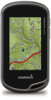
Oregon® 600 Series Owner's Manual April 2013 190-01552-00_0A Printed in Taiwan - Garmin Oregon 600t | Owner's Manual - Page 2
of this manual without obligation to notify any person or organization of such changes or improvements. Go to www.garmin.com for current updates and supplemental information concerning the use of this product. Garmin®, the Garmin logo, Auto Lap®, BlueChart®, City Navigator®, Oregon®, and TracBack - Garmin Oregon 600t | Owner's Manual - Page 3
the Attempt 6 chirp 6 Enabling chirp Searching 6 Finding a Geocache with a chirp 7 Fitness 7 Running or Cycling with Your Device 7 History 7 Viewing an Activity 7 Deleting an Activity 7 Using Garmin Connect 7 Optional Fitness Accessories 7 Pairing Your ANT + Sensors 7 Tips for Pairing - Garmin Oregon 600t | Owner's Manual - Page 4
13 File Types 13 Installing a Memory Card 13 Connecting the Device to Your Computer 14 Transferring Files to Your Device 14 Deleting Files 14 Disconnecting the USB Cable 14 Troubleshooting 14 Viewing Device Information 14 Updating the Software 14 Resetting the Device 14 Registering Your - Garmin Oregon 600t | Owner's Manual - Page 5
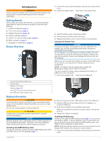
range of 32 to 122°F (0 to 50°C). You can charge the battery using a standard wall outlet or a USB port on your computer. 1 Pull up the weather cap from the mini-USB port . À Á Camera lens (650 and 650t only) À Power key Á Battery cover D-ring  User key (page 10) à microSD™ card slot - Garmin Oregon 600t | Owner's Manual - Page 6
to www.garmin.com / aboutGPS. 1 Hold . 2 Wait while the device locates satellites. When turns green, your device has acquired satellite signals. The time and date are set automatically based on the GPS position. 3 Walk around to record a track (page 3). 4 Select an option: • Select Map to view - Garmin Oregon 600t | Owner's Manual - Page 7
available in all areas and maps. Optional Maps You can use additional maps with the device, such as BirdsEye satellite imagery, BlueChart® g2, and City Navigator® detailed maps. Detailed maps may contain additional points of interest, such as restaurants or marine services the map, select Review. - Garmin Oregon 600t | Owner's Manual - Page 8
mounted volumes on Mac® computers. NOTE: Some computers with multiple network drives cannot display device drives. See your operating system help file to learn how to map the drive. 3 Open the Garmin or memory waypoint, geocache, photo, or any saved location in the device. You can use the map or - Garmin Oregon 600t | Owner's Manual - Page 9
outdoors. To improve heading accuracy, do not stand near manually calibrate the compass. 1 Select Compass > > Calibrate Compass > Start. 2 Follow the on-screen instructions. Course Pointer The course pointer is most useful You can take photos with the Oregon 650 and 650t. When you take a photo, - Garmin Oregon 600t | Owner's Manual - Page 10
.com to upload your rating. chirp™ A chirp is a small Garmin accessory that is programmed and left in a geocache. You can use your device to find a chirp in a geocache. For more information about the chirp, see the chirp Owner's Manual at www.garmin.com. Enabling chirp Searching 1 Select Setup - Garmin Oregon 600t | Owner's Manual - Page 11
Select Review. Deleting an Activity 1 Select Activity History. 2 Select an activity. 3 Select Delete > Yes. Using Garmin Connect 1 Connect the device to your computer using the USB cable. 2 Go to www.garminconnect.com/ start. 3 Follow the on-screen instructions. Optional Fitness Accessories - Garmin Oregon 600t | Owner's Manual - Page 12
data when paired with another compatible device or smartphone using Bluetooth® or ANT + wireless technology. You can share waypoints, geocaches, routes, tracks, and custom maps. You can share photos with the Oregon 650 and 650t models. 1 Select Share Wirelessly. 2 Select an option: • Select Send - Garmin Oregon 600t | Owner's Manual - Page 13
> > Use With GPS Off. Simulating a Location 1 Select Satellite > > Use With GPS Off. 2 Select > Set Location On Map. 3 Select a location. 4 Select Use. Customizing the Device Adjusting the Backlight Brightness Extensive use of screen backlighting can significantly reduce battery life. You can - Garmin Oregon 600t | Owner's Manual - Page 14
environments and faster position acquisition. Using GPS and GLONASS can reduce battery life more than GPS only. Serial Interface Settings Select Setup > System > Interface. Garmin Spanner: Allows you to use the device USB port with most NMEA 0183-compliant mapping programs by creating a virtual - Garmin Oregon 600t | Owner's Manual - Page 15
drawing speed decreases the battery life. Advanced Map Settings Select Setup > Map > Advanced Setup. Detail: Sets the amount of detail shown on the map. Showing more detail may cause the map to redraw more slowly. Shaded Relief: Shows detail relief on the map (if available) or turns off shading - Garmin Oregon 600t | Owner's Manual - Page 16
list by names or codes. Geocache Style: Sets the display style for geocache data. chirp Searching: Allows the device to search for a geocache containing a chirp accessory (page 6). Program chirp: Programs the chirp accessory. See the chirp owner's manual at www.garmin.com. Filter Setup: Allows - Garmin Oregon 600t | Owner's Manual - Page 17
timeout (page 10). • Use battery save mode (page 13). • Decrease the map drawing speed (page 11). • Exit the camera application when you are not taking photos. Turning On Battery Save Mode You can use battery save mode to prolong the battery life. Select Setup > Display > Battery Save > On. In - Garmin Oregon 600t | Owner's Manual - Page 18
. Select Setup > About. Updating the Software NOTE: Updating the software does not erase any of your data or settings. 1 Connect your device to a computer using the USB cable. 2 Go to www.garmin.com/ products / webupdater. 3 Follow the on-screen instructions. Resetting the Device If the device - Garmin Oregon 600t | Owner's Manual - Page 19
accessories to display data. 24hr Max Temperature: The maximum temperature recorded in the last 24 hours. 24hr Min Temperature: The minimum temperature recorded in the last 24 hours. Accuracy Of GPS Battery Level: The remaining battery the current lap. Date: The current on your user profile, - Garmin Oregon 600t | Owner's Manual - Page 20
for the road. Not available in all maps and in all areas. Always reset. Stopwatch Timer: The stopwatch time for the current activity. Sunrise: The time of sunrise based on your GPS position. Sunset: The time of sunset based on your GPS Zone % of Maximum Heart Rate 1 50-60% 2 60-70% 3 70-80 - Garmin Oregon 600t | Owner's Manual - Page 21
all user data 14 history 7 device care 13 registration 14 resetting 14 display settings 10 downloading, geocaches 6 E elevation 4, 5 plot 5 F files, transferring 6, 13, 14 fitness 7, 12 flashlight 8 Index G Garmin Connect, storing data 7 geocaches 6, 7, 13 downloading 6 settings 12 GLONASS 10 GPS - Garmin Oregon 600t | Owner's Manual - Page 22
www.garmin.com/support 913-397-8200 1-800-800-1020 +32 2 672 52 54 +49 (0)180 6 427646 00800 4412 454 +44 2380 662 915 0808 238 0000 +44 870
-
 1
1 -
 2
2 -
 3
3 -
 4
4 -
 5
5 -
 6
6 -
 7
7 -
8
-
9
-
10
-
11
-
12
-
13
-
14
-
15
-
16
-
17
-
18
-
19
-
20
-
21
-
22
 |
 |
Oregon
®
600 Series
Owner’s Manual
April 2013
190-01552-00_0A
Printed in Taiwan