Garmin Oregon 650t Owner's Manual
Garmin Oregon 650t Manual
 |
View all Garmin Oregon 650t manuals
Add to My Manuals
Save this manual to your list of manuals |
Garmin Oregon 650t manual content summary:
- Garmin Oregon 650t | Owner's Manual - Page 1
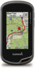
Oregon® 600 Series Owner's Manual April 2013 190-01552-00_0A Printed in Taiwan - Garmin Oregon 650t | Owner's Manual - Page 2
of this manual without obligation to notify any person or organization of such changes or improvements. Go to www.garmin.com for current updates and supplemental information concerning the use of this product. Garmin®, the Garmin logo, Auto Lap®, BlueChart®, City Navigator®, Oregon®, and TracBack - Garmin Oregon 650t | Owner's Manual - Page 3
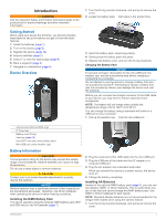
Table of Contents Introduction 1 Getting Started 1 Device Overview 1 Battery Information 1 Installing the NiMH Battery Pack 1 Installing AA Batteries 1 Turning On the Device 2 Acquiring Satellites Signals and Recording a Track 2 Using the Touchscreen 2 Waypoints, Routes, and Tracks 2 - Garmin Oregon 650t | Owner's Manual - Page 4
the USB Cable 14 Troubleshooting 14 Viewing Device Information 14 Updating the Software 14 Resetting the Device 14 Registering Your Device 14 Getting More Information 14 Appendix 14 Attaching the Carabiner Clip 14 Removing the Carabiner Clip 14 Optional Maps 14 tempe 14 Data - Garmin Oregon 650t | Owner's Manual - Page 5
Safety and Product Information guide in the product box for product warnings and other important information. Getting Started When using your device the first time, you should complete these tasks to set up the device and get to know the basic features. 1 Install the batteries (page 1). 2 Turn on - Garmin Oregon 650t | Owner's Manual - Page 6
The default function of the user key marks a waypoint. 2 If necessary, select a field to make changes to the waypoint. 3 Select Save. Marking a Waypoint Using the Map 1 Select Map. 2 Select a location on the map. 3 Select the information bar at the top of the screen. 4 Select > OK. Finding - Garmin Oregon 650t | Owner's Manual - Page 7
available in all areas and maps. Optional Maps You can use additional maps with the device, such as BirdsEye satellite imagery, BlueChart® g2, and City Navigator® detailed maps. Detailed maps option: • To view the point on the map, select Review. • To change the order of the points on the route, - Garmin Oregon 650t | Owner's Manual - Page 8
screen. Information about the location appears. 6 Select > OK. Changing the Track Color You can change the color of a track to improve the view on the map hunted. You can use BaseCamp™ to create and manage your adventures. For more information, go to http: / / adventures .garmin .com. Sending - Garmin Oregon 650t | Owner's Manual - Page 9
changes, you can manually calibrate the compass. 1 Select Compass > > Calibrate Compass > Start. 2 Follow the on-screen instructions. Course Pointer The course pointer is most useful Photos Camera and Photos You can take photos with the Oregon 650 and 650t. When you take a photo, the geographic - Garmin Oregon 650t | Owner's Manual - Page 10
chirp™ A chirp is a small Garmin accessory that is programmed and left in a geocache. You can use your device to find a chirp in a geocache. For more information about the chirp, see the chirp Owner's Manual at www.garmin.com. Enabling chirp Searching 1 Select Setup > Geocaching. 2 Select chirp - Garmin Oregon 650t | Owner's Manual - Page 11
Select Review. Deleting an Activity 1 Select Activity History. 2 Select an activity. 3 Select Delete > Yes. Using Garmin Connect 1 Connect the device to your computer using the USB cable. 2 Go to www.garminconnect.com/ start. 3 Follow the on-screen instructions. Optional Fitness Accessories - Garmin Oregon 650t | Owner's Manual - Page 12
fitness user profile (page 12). You can manually adjust the heart rate zones according to your fitness goals (page 7). 1 Select Setup > using Bluetooth® or ANT + wireless technology. You can share waypoints, geocaches, routes, tracks, and custom maps. You can share photos with the Oregon 650 - Garmin Oregon 650t | Owner's Manual - Page 13
> > Use With GPS Off. Simulating a Location 1 Select Satellite > > Use With GPS Off. 2 Select > Set Location On Map. 3 Select a location. 4 Select Use. Customizing the Device Adjusting the Backlight Brightness Extensive use of screen backlighting can significantly reduce battery life. You can - Garmin Oregon 650t | Owner's Manual - Page 14
environments and faster position acquisition. Using GPS and GLONASS can reduce battery life more than GPS only. Serial Interface Settings Select Setup > System > Interface. Garmin Spanner: Allows you to use the device USB port with most NMEA 0183-compliant mapping programs by creating a virtual - Garmin Oregon 650t | Owner's Manual - Page 15
drawing speed decreases the battery life. Advanced Map Settings Select Setup > Map > Advanced Setup. Detail: Sets the amount of detail shown on the map. Showing more detail may cause the map to redraw more slowly. Shaded Relief: Shows detail relief on the map (if available) or turns off shading - Garmin Oregon 650t | Owner's Manual - Page 16
data. chirp Searching: Allows the device to search for a geocache containing a chirp accessory (page 6). Program chirp: Programs the chirp accessory. See the chirp owner's manual at www.garmin.com. Filter Setup: Allows you to create and save custom filters for geocaches based on specific factors - Garmin Oregon 650t | Owner's Manual - Page 17
13). • Decrease the map drawing speed (page 11). • Exit the camera application when you are not taking photos. Turning On Battery Save Mode You can use battery save mode to prolong the battery life. Select Setup > Display > Battery Save > On. In battery save mode, the screen shuts off when the - Garmin Oregon 650t | Owner's Manual - Page 18
device to a computer using the USB cable. 2 Go to www.garmin.com/ products / webupdater. 3 Follow the on-screen instructions. Resetting the Device If the device stops responding, you may need to reset it. This does not erase any of your data or settings. 1 Remove the batteries. 2 Reinstall the - Garmin Oregon 650t | Owner's Manual - Page 19
to the change in vertical distance. Glide Ratio To Dest: The glide ratio required to descend from your current position to the destination elevation. You must be navigating for this data to appear. GPS Elevation: The altitude of your current location using GPS. GPS Heading: The direction you are - Garmin Oregon 650t | Owner's Manual - Page 20
direction of the next waypoint or turn. You must be navigating for this data to appear. Speed: The current rate of travel. Speed Limit: The reported speed limit for the road. Not available in all maps to appear. To Course: The direction in which you must move to get back on the route. You must - Garmin Oregon 650t | Owner's Manual - Page 21
fishing times 8 K keys 1, 10 L lifetime athlete 12 locations editing 2 saving 2 locking, screen 9 M main menu 9 man overboard (MOB) 4 map settings 11 maps 2, 4 data fields 9 navigating 3 optional 3, 14 settings 11 marine alarms setup 12 settings 12 memory card 13 microSD card 1, 13. See memory card - Garmin Oregon 650t | Owner's Manual - Page 22
www.garmin.com/support 913-397-8200 1-800-800-1020 +32 2 672 52 54 555 + 46 7744 52020 Garmin International, Inc. 1200 East 151st Street Olathe, Kansas 66062, USA Garmin (Europe) Ltd. Liberty House, Hounsdown Business Park Southampton, Hampshire, SO40 9LR UK Garmin Corporation No. 68, Zhangshu
-
 1
1 -
 2
2 -
 3
3 -
 4
4 -
 5
5 -
 6
6 -
 7
7 -
8
-
9
-
10
-
11
-
12
-
13
-
14
-
15
-
16
-
17
-
18
-
19
-
20
-
21
-
22
 |
 |
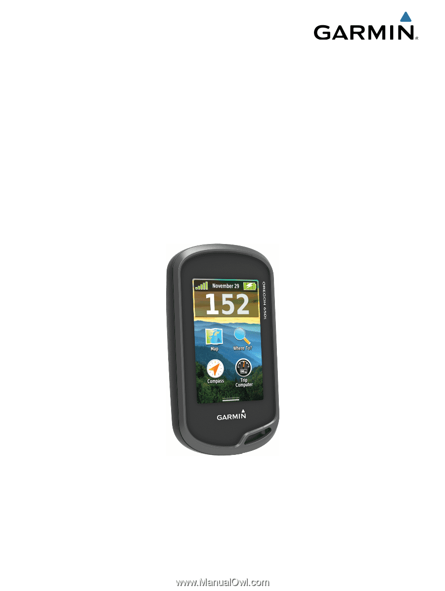
Oregon
®
600 Series
Owner’s Manual
April 2013
190-01552-00_0A
Printed in Taiwan