Magellan MapSend Bluenav XL3 User Manual
Magellan MapSend Bluenav XL3 - GPS Map Manual
 |
UPC - 763357113655
View all Magellan MapSend Bluenav XL3 manuals
Add to My Manuals
Save this manual to your list of manuals |
Magellan MapSend Bluenav XL3 manual content summary:
- Magellan MapSend Bluenav XL3 | User Manual - Page 1
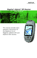
Magellan® eXplorist™ GPS Receiver Using MapSend™ This manual provides basic operation instructions for the MapSend line of Magellan software with your eXplorist GPS receiver. - Magellan MapSend Bluenav XL3 | User Manual - Page 2
© 2005 Thales S.A. All rights reserved. The Magellan logo, Magellan, MapSend, and eXplorist are trademarks of Thales. - Magellan MapSend Bluenav XL3 | User Manual - Page 3
Magellan eXplorist uses a USB port to transfer data, and provides a file management system much like Windows folders, so users can work with multiple maps and personal data files. To prepare map regions for eXplorist, you MUST first save the map region on your hard drive using the MapSend software - Magellan MapSend Bluenav XL3 | User Manual - Page 4
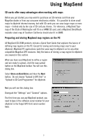
MapSend map regions on the PC All MapSend CD-ROM products include a Quick Start Guide that explains the basics of defining map regions on the PC. Except for saving and moving maps over to your eXplorist, MapSend PC applications work the same way for eXplorist as for any other compatible Magellan GPS - Magellan MapSend Bluenav XL3 | User Manual - Page 5
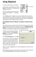
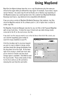
can download it from the eXplorist support section of the Magellan Web site. To transfer stored map regions to SD cards or eXplorist memory, click the Conversion Manager icon on your desktop. You will see this dialog box on the PC: Select Transfer Map Regions and click Next. The next window in - Magellan MapSend Bluenav XL3 | User Manual - Page 6
you used.Important note: files created from MapSend Worldwide Basemap must have a .mgi extension to be compatible with eXplorist. If you are using a version of MapSend Worldwide Basemap, that produces .img files, check the Magellan website for the software patch v.1.30 or higher that is needed - Magellan MapSend Bluenav XL3 | User Manual - Page 7
have the flexibility of switching to different maps, either stored internally or on SD cards. This provides your Magellan eXplorist the ability to display and navigate using highly detailed maps, limited only by the amount of memory you have at your disposal and the MapSend products you are using. 5 - Magellan MapSend Bluenav XL3 | User Manual - Page 8
631180-01 B Thales Consumer Products 960 Overland Court San Dimas, California USA 91773 Tel: 909 394 5000 Fax: 909 394 7050 www.magellangps.com A product of Thales
-
 1
1 -
 2
2 -
 3
3 -
 4
4 -
 5
5 -
 6
6 -
 7
7 -
8
 |
 |
Magellan
®
eXplorist
™
GPS Receiver
Using MapSend
™
This manual provides basic
operation instructions for
the MapSend line of
Magellan software with your
eXplorist GPS receiver.