Magellan MapSend Lakes USA Quick Reference Guide
Magellan MapSend Lakes USA - GPS Map Manual
 |
UPC - 763357110302
View all Magellan MapSend Lakes USA manuals
Add to My Manuals
Save this manual to your list of manuals |
Magellan MapSend Lakes USA manual content summary:
- Magellan MapSend Lakes USA | Quick Reference Guide - Page 1
MapSend™ Series Software Quick Reference Guide Introduction: Magellan's MapSend™ Streets Gold and MapSend™ Topo of the United States CD-ROM enhances the utility of Magellan map-capable receivers with even greater mapping detail and useful information management capabilities. MapSend will upload data - Magellan MapSend Lakes USA | Quick Reference Guide - Page 2
4. Turn on your personal computer. 5. Make sure you have correctly installed the MapSend software. (Please refer to the back cover for installation instructions.) 6. Start the MapSend program from the Windows start menu or simply insert the MapSend CD-ROM and click on the "Run" button. When starting - Magellan MapSend Lakes USA | Quick Reference Guide - Page 3
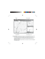
Toolbar Overview Map Map Window Saved Regions List Overview Map: (The smaller map located in the upper right-hand corner frame) - The Overview Map window is used for a more global view of the map. - If you left-click on the Overview Map window, the overview frame's center is moved to the clicked - Magellan MapSend Lakes USA | Quick Reference Guide - Page 4
Map Window: - The Map Window displays the map itself. - When navigating the map, make sure the focus is on the Map Window by clicking the left mouse button within the Map Window. Panning Mode: - From the Tools menu choose Pan or click on the toolbar. - The mouse pointer changes to . - Click and - Magellan MapSend Lakes USA | Quick Reference Guide - Page 5
Saved Regions List: - The Saved Regions List is the window where you view the attributes of regions to be uploaded to the GPS receiver. - Regions contained in the Saved Regions List are displayed in the Map Window as rectangles with translucent colored borders. Drawing and Cutting Rectangular - Magellan MapSend Lakes USA | Quick Reference Guide - Page 6
for Topographic is available only with the MapSend Topo of the United States software.) - Clicking on the "T" or , choose Upload to GPS... - Follow the instructions in the dialog information box. - If the - Refer to the User Manual on downloading waypoints, tracks and routes from the GPS receiver to - Magellan MapSend Lakes USA | Quick Reference Guide - Page 7
The toolbar provides quick mouse access to most tools used in MapSend. - To hide or display the Toolbar, choose Toolbar from the . Set a scale in the Map Window to view the continental USA. Set a scale in the Map Window to view the entire uploading/downloading of additional data. Display the About dialog - Magellan MapSend Lakes USA | Quick Reference Guide - Page 8
-
 1
1 -
 2
2 -
 3
3 -
 4
4 -
 5
5 -
 6
6 -
 7
7 -
8
 |
 |

MapSend™ Series Software Quick Reference Guide
Introduction:
Magellan’s MapSend™ Streets
Gold and MapSend™ Topo of the United States
CD-ROM enhances the utility of Magellan map-capable receivers with even
greater mapping detail and useful information management capabilities.
MapSend will upload data to the GPS receiver to view fully detailed street
maps for any region in the United States.
MapSend will also locate street
addresses on a map.
You can also find any USA city and airport, along with
many parks, lakes, streams, rivers, and dams.
MapSend contains a wide as-
sortment of built-in POIs that you can use for route management. You can
upload any category of POIs to your GPS receiver to be used the same as any
waypoint you have in your receiver.
The software’s waypoint and route man-
agement features allow users to upload, download and customize data for
specific navigation needs.
For route planning purposes, MapSend Streets
automatically measures the distance of each leg and the total distance to the
destination.
MapSend Topo of the United States also includes topographic
maps and a vertical profile utility.
Both versisons of MapSend are designed for
use with Windows 95, 98 or NT.
This Quick Reference Guide is a supplement to the User Manual that is avail-
able to you from within the MapSend software.
While using MapSend, you
can refer to the User Manual and get detailed answers to your questions about
this software.