Magellan eXplorist 200 Manual - English
Magellan eXplorist 200 - Hiking GPS Receiver Manual
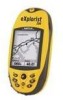 |
UPC - 763357109375
View all Magellan eXplorist 200 manuals
Add to My Manuals
Save this manual to your list of manuals |
Magellan eXplorist 200 manual content summary:
- Magellan eXplorist 200 | Manual - English - Page 1
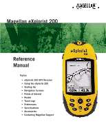
Magellan eXplorist 200 Reference Manual Topics: • eXplorist 200 GPS Receiver • Using the eXplorist 200 • Starting Up • Navigation Screens • Points of Interest • Routes • Track Logs • Preferences • Specifications • Accessories • Contacting Magellan Support - Magellan eXplorist 200 | Manual - English - Page 2
trees. USE PROPER ACCESSORIES Use only Magellan cables and antennas; the use of non-Magellan cables and antennas may severely degrade performance or damage the receiver, and will void the warranty. LICENSE AGREEMENT Thales Navigation grants you, the purchaser, the right to use the software supplied - Magellan eXplorist 200 | Manual - English - Page 3
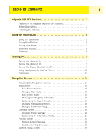
Table of Contents i eXplorist 200 GPS Receiver 1 Features of the Magellan eXplorist GPS Receiver 1 Button Descriptions 2 Installing the Batteries 4 Using the eXplorist 200 5 Going to a Destination 5 Saving Your Position 6 Tracing Your Steps 7 Additional Features 8 Summary 8 Starting Up - Magellan eXplorist 200 | Manual - English - Page 4
Nearest 30 Searching for a Preloaded POI using Alphabetical 31 Editing a User-Created POI 32 Deleting a User-Created POI 33 Viewing a User-Created POI on the Map Screen 34 Copying a Preloaded POI 35 Viewing a Preloaded POI on the Map Screen 36 Routes 37 GOTO Routes 37 Creating a GOTO Route - Magellan eXplorist 200 | Manual - English - Page 5
GPS 61 Setting the Map Units 63 Selecting Navigational Units of Measure 63 Selecting the North Reference 64 Selecting the Coordinate System 65 Selecting the Map Datum 66 Using the Power Management Tool 67 Setting the Power-Off Timer 67 Setting the Light Timer 68 Personalizing the eXplorist - Magellan eXplorist 200 | Manual - English - Page 6
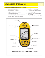
eXplorist 200 GPS Receiver 1 Features of the Magellan eXplorist GPS receiver: • Built-in background map • Preloaded points of interest • Rugged design, rubber-protected • 8 MB of background map • Superior tracking with 14 parallel channels • 14 hour+ battery life on 2 AA batteries • TrueFix™ GPS - Magellan eXplorist 200 | Manual - English - Page 7
eXplorist 200 GPS Receiver 2 Button Descriptions: On/Off Backlight ENTER ESCAPE ZOOM IN ZOOM OUT MENU NAV MARK GOTO Arrow joystick Turns the eXplorist on or off. Turns the display backlight on. Sequences from off to low to high intensity. Used to access highlighted menu items or accept - Magellan eXplorist 200 | Manual - English - Page 8
eXplorist 200 GPS Receiver Wrist Lanyard Strap Mounting Hole Battery Door 3 Battery Door Fastener (Unscrew to open battery door to install batteries.) eXplorist 200 GPS Receiver (back) - Magellan eXplorist 200 | Manual - English - Page 9
eXplorist 200 GPS Receiver 4 Installing the Batteries The eXplorist 200 uses two AA batteries that are the last viewed navigation screen. Setting the Light Timer From any Nav screen press MENU. Highlight Preferences and press ENTER. Highlight Pwr Management and press ENTER. Use the down arrow - Magellan eXplorist 200 | Manual - English - Page 10
eXplorist is to use the GPS satellites to compute your present position. This is done internally in the software of your eXplorist. The only thing that you need to do is to give your eXplorist a clear view of the sky so that it can receive switch to the Satellite Status screen. Here, you will - Magellan eXplorist 200 | Manual - English - Page 11
be able to follow these instructions exactly. To compensate for that, your eXplorist automatically updates the route, providing you with up-to-date information about getting to your destination. GOTO routes are the simplest and most commonly used feature of your eXplorist 200. With just the GOTO - Magellan eXplorist 200 | Manual - English - Page 12
Your eXplorist enables you to use this Track, reverse it and navigate you along the same path that you followed to get you back to your destination. You might drive to the ranger station and follow the trail that leads you to the waterfalls you have been wanting to see. With your eXplorist turned on - Magellan eXplorist 200 | Manual - English - Page 13
200 8 Additional Features Your Magellan eXplorist contains all of the features that you would expect from a high-quality Magellan-brand handheld navigation device, as well as many more to make your outdoor experience more enjoyable. You have the ability to customize the navigation screens - Magellan eXplorist 200 | Manual - English - Page 14
need to press ENTER when the Startup screen is displayed. You have approximately 30 seconds between pressing the POWER button and pressing the ENTER button, otherwise the eXplorist will automatically turn itself off. Turning the eXplorist Off To turn the eXplorist off, press the POWER button on the - Magellan eXplorist 200 | Manual - English - Page 15
Starting Up 10 Using the eXplorist for the First Time Turn the eXplorist on. Press the Power button. When the Startup screen is displayed, press ENTER. Select Language. When you turn on the eXplorist for the first time, Language you are given the option of selecting one of the ten languages - Magellan eXplorist 200 | Manual - English - Page 16
Satellite Status screen will continuously update, and you will be 3D Position Fix able to graphically see how well your eXplorist is performing. Tracking 7.... When the eXplorist has enough information to compute a position fix, the Satellite Status screen is replaced with the Map screen. The - Magellan eXplorist 200 | Manual - English - Page 17
display. Review the information you entered using the information you just provided. Tip: If you notice that the satellite signal-strength bars are still not changing, try moving to a new location where you have a clearer view of the sky. As before, when the eXplorist computes the initial position, the Map screen - Magellan eXplorist 200 | Manual - English - Page 18
concludes the initial startup procedure for the Magellan eXplorist 200. Once the Map screen is displayed, you have successfully initialized the eXplorist and are ready to go. Now would be a good time to familiarize yourself with the different navigation screens (using the NAV button) and to set any - Magellan eXplorist 200 | Manual - English - Page 19
Tracking 7.... ESC ESC NAV NAV Tip: The ESC button will also set through the navigation screens, just like the NAV button but in the reverse order. Map Screen The first, and most commonly used, screen is the Map screen. The Map screen displays your position, as well as POIs and any background - Magellan eXplorist 200 | Manual - English - Page 20
Navigation Screens 15 Map Screen Overview Route Marker Track Indicator Map Scale Data Field 1 Glendora 210 San Dimas ent vina 10 10 1.60mi Heading Speed 352 o M 4.3 M H Position Cursor Pan Cursor (used when in Cursor Mode) Hourglass (used when position is unknown and eXplorist is - Magellan eXplorist 200 | Manual - English - Page 21
that can be used to assist you in navigating to your destination. However, you may want to display more of the map and may not need this information. The eXplorist gives you the capability to turn this information on or off. 1. While viewing the Map screen, press MENU. 2. With Hide Map Info or Show - Magellan eXplorist 200 | Manual - English - Page 22
Navigation Screens 17 Customizing the Map Information The information displayed at the bottom of the screen can be customized to change what is shown in the two map • Date To customize the map information: 1. While viewing the Map screen, press MENU. 2. Use the Arrow joystick to highlight - Magellan eXplorist 200 | Manual - English - Page 23
right corner of the display. This arrow points in the direction of true north. To change the map orientation: 1. While viewing the Map screen, press MENU. 2. Use the Arrow joystick to highlight Map Setup. 3. Press ENTER. 4. Use the Arrow joystick to highlight the Orientation field. 5. Press - Magellan eXplorist 200 | Manual - English - Page 24
with the ability to view the text and map details more easily, depending on where you are navigating. To change the primary usage: 1. While viewing the Map screen, press MENU. 2. Use the Arrow joystick to highlight Map Setup. 3. Press ENTER. 4. Use the Arrow joystick to highlight the Primary Usage - Magellan eXplorist 200 | Manual - English - Page 25
Navigation Screens 20 Compass Screen The Compass screen provides an easy-to-use graphical compass that should be familiar to most GPS users. Highlights of the Compass screen: • With an active route, the top of the Compass screen displays the name of the destination. • Press MENU and select - Magellan eXplorist 200 | Manual - English - Page 26
Navigation Screens 21 Customizing the Information Fields The information displayed at the top of the screen can be customized to information • Time • Date To customize the map information: 1. While viewing the Compass screen, press MENU. 2. Use the Arrow joystick to highlight Customize page. - Magellan eXplorist 200 | Manual - English - Page 27
format that is familiar to seasoned navigators. Highlights of the Position screen: • Position is displayed in textual format using the coordinate system selected. (See Setting Coordinate System for information on how to select the coordinate system.) • Elevation information is displayed. (Accurate - Magellan eXplorist 200 | Manual - English - Page 28
Navigation Screens 23 Resetting the Trip Odometer Whenever you begin a trip and you want to record how far you have travelled, you will want to reset the trip odometer to zero. To reset the trip odometer: 1. While viewing the Position screen, press MENU. 2. Use the Arrow joystick to highlight - Magellan eXplorist 200 | Manual - English - Page 29
Navigation Screens 24 Satellite Status Screen The Satellite Status screen is a handy way to visually see just how well the eXplorist is tracking and receiving satellite signals. Highlights of the Satellite Status screen been locked on. Satellite Status Screen Overview Status of position fix - Magellan eXplorist 200 | Manual - English - Page 30
200: POIs that you have marked (saved) and POIs that have been stored in your eXplorist as part of the built-in background map. These two classes of POIs are accessed from the same MENU option and can be used independently or combined to create routes. Marking Your Position The most common - Magellan eXplorist 200 | Manual - English - Page 31
the top of the keypad. 4b. If the Name field was selected: Use the Arrow joystick to select the character desired and press ENTER. If Mark When you are Save Cancel Mark Screen with Name field highlighted satisfied with the name, highlight OK and press ENTER. Note: User-saved POI names can only - Magellan eXplorist 200 | Manual - English - Page 32
, you may want to save a position that is not your present position. The eXplorist offers you two ways of doing that. You can modify the coordinates of your present position or you can use the Cursor mode of the Map screen to pan to the location you want to mark. Marking a Position by Entering - Magellan eXplorist 200 | Manual - English - Page 33
marking a position, other than your present position, by moving the cursor around the map to a place where you want to create a POI. 1. While viewing the Map screen, use the Arrow joystick to put the eXplorist into Cursor mode. 2. Continue moving the crosshair cursor until you are over the location - Magellan eXplorist 200 | Manual - English - Page 34
that you have saved and background map POIs that came with your eXplorist, can be accessed using the POI database. Once the screen. Searching for a User-Entered POI When searching for a POI that you have entered, you have two options to choose from: nearest or alphabetical. 1. Press MENU. 2. Use - Magellan eXplorist 200 | Manual - English - Page 35
to select the category that the POI will be found in. 1. Press MENU. 2. Use the Arrow joystick to highlight Pts of Interest. 3. Press ENTER. 4. Use the Arrow joystick in an up/down motion to highlight Background Map. 5. Use the Arrow joystick in a left/right motion to select Nearest. 6. Press ENTER - Magellan eXplorist 200 | Manual - English - Page 36
search 11. Press ENTER. 12. Use the Arrow joystick to highlight the POI desired. From here you can copy or view on the map the POI you have highlighted by pressing ENTER and selecting the desired function from the menu. Detailed information on these functions can be found later in this manual. - Magellan eXplorist 200 | Manual - English - Page 37
Icon Name MAGELLAN Location 34°06.560N 117°49.566W Elevation 924 FT Message CREATE MESSAGE? 13b. If the Name field was selected: Use the Arrow ENTER. Note: User-entered POI names can be only eight characters long (including spaces). 13c. If the Message field was selected: Use the keypad displayed, - Magellan eXplorist 200 | Manual - English - Page 38
Points of Interest 33 Deleting a User-Created POI POIs that you have saved can be deleted using this operation. If you have 8. Press ENTER. Note: If the POI selected is used in a route, you will be asked to confirm the deletion. 9. Use the Arrow joystick to highlight Delete POI. 10. Confirm - Magellan eXplorist 200 | Manual - English - Page 39
to highlight the POI to be viewed. 8. Press ENTER. 9. Use the Arrow joystick to highlight View on Map. 10. Press ENTER. 11. The Map screen will be displayed in the Cursor mode. The cursor will be directly over the POI you have selected. You may use the Zoom buttons to change the scale of the - Magellan eXplorist 200 | Manual - English - Page 40
POI POIs that have been preloaded as part of the background map can be saved as a user-entered POIs. Preloaded POIs cannot be deleted; it just copies it to the My Points of Interest portion of the database. 1. Press MENU. 2. Use the Arrow joystick to highlight Pts of Interest. 3. Press ENTER - Magellan eXplorist 200 | Manual - English - Page 41
Arrow joystick to highlight View. 11. Press ENTER. 12. The Map screen will be displayed in the Cursor mode. The cursor will be directly over the POI you have selected. You may use the Zoom buttons to change the scale of the map displayed; and if your position icon is within range, it will be - Magellan eXplorist 200 | Manual - English - Page 42
Routes 37 Routes are the least understood and one of the most important functions of a GPS receiver. The better you understand routes and how to use them, the more enjoyment you will receive from using your eXplorist. The simpliest and most common form of a route is a GOTO route. A GOTO route is a - Magellan eXplorist 200 | Manual - English - Page 43
Detailed instructions for searching the POI Rocky Slo database can be found in the Points of Interest section 50 CABIN 88 of this manual. Map screen with a GOTO route active. Notice the After you press ENTER, the last viewed navigation screen will be line on the screen that displayed, updated - Magellan eXplorist 200 | Manual - English - Page 44
the destination.) 6. Press ENTER. Creating a GOTO using the cursor confirmation After you press ENTER, the last viewed navigation screen will be displayed, updated as needed to provide information about the GOTO route you have created. On the Map screen, a line will be drawn representing the GOTO - Magellan eXplorist 200 | Manual - English - Page 45
a GOTO Route to a Map Object This will create a GOTO route to a map object (city, highway, user POI, etc.) that you have indicated by moving the crosshair cursor on the Map screen over the map object. 1. While viewing the Map screen, use the Arrow joystick, causing the eXplorist to go into Cursor - Magellan eXplorist 200 | Manual - English - Page 46
in the route.) • Multi-leg routes remain active even after the eXplorist has been turned off. • Multi-leg routes can be edited, reversed, deleted, or viewed on the map. • When a multi-leg route is active, you can switch which leg will be used as the next destination point. In the above example, you - Magellan eXplorist 200 | Manual - English - Page 47
a Multi-leg Route The eXplorist will provide you with an empty list for your route, and you can use the POIs saved in the already entered. You can insert, delete, or replace a POI that is already in the route list. Create Route screen Inserting: Use the Arrow joystick to highlight the POI that - Magellan eXplorist 200 | Manual - English - Page 48
turn it off (deactivate) or activate a new route. GOTOs are automatically activated when they are created, while multi-leg routes need to be activated manually. 1. Press MENU. 2. Use the Arrow joystick to highlight Routes. Route List 1 Tahoe Camp 3. Press ENTER. 2 Trout Spot 3 Magellan 4. Use - Magellan eXplorist 200 | Manual - English - Page 49
from active routes), you would follow the instructions below and tell the eXplorist to set the next leg to the ranger station. The route would be recomputed, eliminating the navigation instructions to go to the stone marker. 1. Press MENU. 2. Use the Arrow joystick to highlight Routes. 3. Press - Magellan eXplorist 200 | Manual - English - Page 50
the POI database for the new POI. The new POI will be added inserting into the route you are creating. Menu Insert POI Delete POI Replace POI Help Deleting: Use the Arrow joystick to highlight the POI you want to delete from the route. Press MENU, highlight Delete POI, and press ENTER - Magellan eXplorist 200 | Manual - English - Page 51
discussed earlier, Camp > Bridge > Marker > Ranger > Swim, would now be Swim > Ranger > Marker > Bridge > Camp. 1. Press MENU. 2. Use the Arrow joystick to highlight Routes. 3. Press ENTER. 4. Use the Arrow joystick to highlight the name of the route you want to reverse. 5. Press MENU. 6. Highlight - Magellan eXplorist 200 | Manual - English - Page 52
Routes 47 Deleting a Route The eXplorist can hold up to 20 different routes. When you have 20 routes saved, you will need to delete one before you can create a new one. 1. Press MENU. 2. Use the Arrow joystick to highlight Routes. 3. Press ENTER. 4. Use the Arrow joystick to highlight the name - Magellan eXplorist 200 | Manual - English - Page 53
, saving you time in creating a new route that is similar to an existing route. Another use would be to copy a route and reverse it. 1. Press MENU. 2. Use the Arrow joystick to highlight Routes. 3. Press ENTER. 4. Use the Arrow joystick to highlight the name of the route you want to copy. 5. Press - Magellan eXplorist 200 | Manual - English - Page 54
Map. 7. Press ENTER. The route is displayed with the map scaled to display the entire route. You can use the Zoom In and Zoom Out buttons to change the scale, and the Arrow joystick to move around the map. 8. When you are done viewing the route, press ESC to return to the Route List screen - Magellan eXplorist 200 | Manual - English - Page 55
trail that you can use later to find your way back, the eXplorist leaves "electronic breadcrumbs" on the map. The advantage here track the eXplorist is recording. Features of Track Logs: • Active track is recording your travels whenever you are moving unless you have intentionally turned it off. - Magellan eXplorist 200 | Manual - English - Page 56
provides the ability to turn off the recording of the active track and then to starting it up again. 1. Press MENU. 2. Use the Arrow joystick to Distance 10.4 M I 6. Press ENTER. Track Log List with Note: The eXplorist will fill in a straight line from the point information at the bottom for - Magellan eXplorist 200 | Manual - English - Page 57
Logging. (If Resume Logging is displayed, the Track Log has already been stopped. Go to step 10.) Legs 3 Distance 525 FT 7. Press ENTER. 8. Use the Arrow joystick to highlight Active Track. Active route menu with New Track highlighted 9. Press MENU. 10. Highlight New Track. 11. Press ENTER. - Magellan eXplorist 200 | Manual - English - Page 58
save your active track log with a name you enter that you can use at some time in the future. This does not erase your presently , an alert will be displayed, informing you of the same and canceling the save. 9. Use the Arrow joystick and ENTER button to assign a name for the track log. Track log - Magellan eXplorist 200 | Manual - English - Page 59
Logging Save BackTrack Clear Track Convert to Route View on Map Help 0.00 After BackTrack has been activated, the last viewed navigation screen will be displayed. The eXplorist will now begin computing the navigation information needed to guide you back to your starting point. NOTE: When you have - Magellan eXplorist 200 | Manual - English - Page 60
ENTER. 4. Use the Arrow joystick to highlight Active Track. 5. Press MENU. 6. Highlight Clear Track. Track Log Active Track Stop Logging Save BackTrack Clear Track Convert to Route View on Map Help 7. Press ENTER. 0.00 The active track is cleared, and you are returned to the Track Log screen. - Magellan eXplorist 200 | Manual - English - Page 61
log and turns it into Use the Arrow joystick to highlight OK when the name has been entered. Track Log Apr-24 Follow Track Reverse Track DeleteTrack Convert to Route View on Map Help 0.00 10. Press ENTER. The route is created with the name you assigned, and you are returned to the Track Log screen - Magellan eXplorist 200 | Manual - English - Page 62
displayed, in the Cursor mode, with the selected track log displayed on the screen. The ZOOM IN and ZOOM OUT buttons can be used to change the map scale, and the cursor can be moved by using the Arrow joystick. When you have finished viewing the track, press ESC to return to the Track - Magellan eXplorist 200 | Manual - English - Page 63
logs on the map. There are three eXplorist will navigate you along your saved track. 1. Press MENU. 2. Use the Arrow joystick to highlight Track Log. 3. Press ENTER. 4. Use turned off alert status.] Press ENTER. The last viewed navigation screen is displayed with the track log selected being used - Magellan eXplorist 200 | Manual - English - Page 64
function to remove track logs that have been previously saved and are no longer needed. 1. Press MENU. 2. Use the Arrow joystick to highlight Track Log. 3. Press ENTER. 4. Use the Arrow joystick to highlight any track log you have previously saved. 5. Press MENU. 6. Highlight Delete Track. 7. Press - Magellan eXplorist 200 | Manual - English - Page 65
GPS (Initializing) to give the eXplorist its approximate location if it has been moved a large distance while turned off. • Access to setting the units of measure for information displayed. • A means to set the north reference used to be either magnetic north or True North. • The coordinate system - Magellan eXplorist 200 | Manual - English - Page 66
acquire its first fix. Many eXplorist users will never need to use the Restart GPS option, but it is available should the need arise. When to use Restart GPS: • When the eXplorist has been moved more than 500 miles (804.67 km) while turned off. • When the eXplorist is sluggish and takes more than - Magellan eXplorist 200 | Manual - English - Page 67
rarely used and is not described in this manual. 7. Press ENTER. Enter Coord USA Americas Europe Asia East Asia West 8. Area. Use the ENTER. 14. Use the Arrow joystick to highlight Done. 15. Press ENTER. 16. The last viewed navigation screen is displayed, and the eXplorist will begin tracking - Magellan eXplorist 200 | Manual - English - Page 68
of Preferences you can select which units of measure for navigation data, the north reference, the coordinate system, and the map datum that will be used by the eXplorist. Selecting Navigational Units of Measure The eXplorist can be set to display navigation data in Miles/Yd/MPH, Miles/Ft/MPH, NM - Magellan eXplorist 200 | Manual - English - Page 69
the data field for North Reference. 7. Press ENTER. 8. Use the Arrow joystick to highlight Magnetic or TRUE. Map Units Nav Units Miles/Ft/MPH North Reference Magnetic Coord System Lat/Lon Map Datum WGS84 9. Press ENTER. The Map Units screen is displayed with the new North Reference shown. You can - Magellan eXplorist 200 | Manual - English - Page 70
required. This option will be used only by experienced users and is not described in this manual. Map Units Nav Units Miles/Ft/MPH North Reference Magnetic Coord System Lat/Lon Map Datum WGS84 9. Press ENTER. The Map Units screen is displayed with the new Coord System shown. You can change other - Magellan eXplorist 200 | Manual - English - Page 71
the data field for Map Datum. 7. Press ENTER. 8. Use the Arrow joystick to highlight the desired map datum. Map Units Nav Units Miles/Ft/MPH North Reference Magnetic Coord System Lat/Lon Map Datum WGS84 9. Press ENTER. The Map Units screen is displayed with the new Map Datum shown. You can - Magellan eXplorist 200 | Manual - English - Page 72
interval or set to Off. 9. Press ENTER. Note: When using a GOTO route you should note that if the eXplorist turns off, the GOTO route is erased. If you have a GOTO route activated and you think that the power timer may elapse and turn the eXplorist off, you might want to set the Power-Off Timer - Magellan eXplorist 200 | Manual - English - Page 73
the backlight to remain on while no buttons have been pressed. 1. Press MENU. 2. Use the Arrow joystick to highlight Preferences. 3. Press ENTER. 4. Use the Arrow joystick to highlight Pwr Management. 5. Press ENTER. 6. Use the Arrow joystick to highlight the data field for Light Timer. 7. Press - Magellan eXplorist 200 | Manual - English - Page 74
the Name field will be displayed on the About screen. Steps to Personalize your eXplorist 1. Press MENU. 2. Use the Arrow joystick to highlight Preferences. 3. Press ENTER. 4. Use the Arrow joystick to highlight Personalize. 5. Press ENTER. 6. Use the Arrow joystick to highlight the data field - Magellan eXplorist 200 | Manual - English - Page 75
(Swedish), and Norsk (Norwegian). Selecting the Language for Your eXplorist 1. Press MENU. 2. Use the Arrow joystick to highlight Preferences. 3. Press ENTER. 4. Use the Arrow joystick to highlight Language. 5. Press ENTER. 6. Use the Arrow joystick to selecte the language desired. 7. Press ENTER - Magellan eXplorist 200 | Manual - English - Page 76
/Routes] • all multi-leg routes [Routes] • all track logs, user-entered POIs, and routes [All] Using Clear Memory, you can also set all of the defaults in the eXplorist to the factory defaults. Clearing All Track Logs 1. Press MENU. 2. Use the Arrow joystick to highlight Preferences. 3. Press ENTER - Magellan eXplorist 200 | Manual - English - Page 77
to highlight Preferences. 3. Press ENTER. 4. Use the Arrow joystick to highlight Clear Memory. 5. Press ENTER. 6. Use the Arrow joystick to highlight All. 7. Confirm. Use the Arrow joystick to highlight Yes to confirm or No to cancel. 8. Press ENTER. 9. The eXplorist will automatically shut off. - Magellan eXplorist 200 | Manual - English - Page 78
Preferences 73 Reseting the eXplorist to Factory Defaults 1. Press MENU. 2. Use the Arrow joystick to highlight Preferences. 3. Press ENTER. 4. Use the Arrow joystick to highlight Reset Default. 5. Press ENTER. 6. Use the Arrow joystick to highlight All. 7. Confirm. Use the Arrow joystick to - Magellan eXplorist 200 | Manual - English - Page 79
Specifications 74 Performance Receiver 14 parallel-channel technology, tracks up to 14 satellites to compute and update information. Antenna Patch Acquisition Times (optimal conditions) Warm less than 1 minute Cold less than 2 minutes Update Rate 1 second continuous Accuracy Position - Magellan eXplorist 200 | Manual - English - Page 80
75 Coordinate Systems Available 11 plus 1 user grid. Lat User-entered Total Up to 500 saved points of interest Name Length 8 characters (including spaces) Built-in (included with background map) Categories Cities, highways, airports, waterways, and parks Navigation Screens Map - Magellan eXplorist 200 | Manual - English - Page 81
wherever your adventure takes you. Part number: 702209 Bike Mounting Bracket Mount your Magellan eXplorist on your bicycle, snowmobile, or motorcycle for convenient operation and viewing. The easy-to-install mounting bracket securely holds your receiver at just the right angle while on the trails - Magellan eXplorist 200 | Manual - English - Page 82
so that if you need support for your Magellan eXplorist in North America, you can direct your questions/comments to the proper person at Thales Navigation. Customers in North America, Central America, South America, Asia, and South Pacific regions. Technical Support If you need technical assistance - Magellan eXplorist 200 | Manual - English - Page 83
Contacting Magellan Support 78 Customers in Europe, Middle East, or Africa regions Contacting Magellan in Europe Technical support and warranty service For Magellan product support and warranty service information in English, French, German, Spanish, Portuguese, Dutch, Norwegian, Finnish and
-
 1
1 -
 2
2 -
 3
3 -
 4
4 -
 5
5 -
 6
6 -
 7
7 -
8
-
9
-
10
-
11
-
12
-
13
-
14
-
15
-
16
-
17
-
18
-
19
-
20
-
21
-
22
-
23
-
24
-
25
-
26
-
27
-
28
-
29
-
30
-
31
-
32
-
33
-
34
-
35
-
36
-
37
-
38
-
39
-
40
-
41
-
42
-
43
-
44
-
45
-
46
-
47
-
48
-
49
-
50
-
51
-
52
-
53
-
54
-
55
-
56
-
57
-
58
-
59
-
60
-
61
-
62
-
63
-
64
-
65
-
66
-
67
-
68
-
69
-
70
-
71
-
72
-
73
-
74
-
75
-
76
-
77
-
78
-
79
-
80
-
81
-
82
-
83
 |
 |

Magellan eXplorist 200
Reference
Manual
Topics:
•
eXplorist 200 GPS Receiver
•
Using the eXplorist 200
•
Starting Up
•
Navigation Screens
•
Points of Interest
• Routes
•
Track Logs
• Preferences
• Specifications
• Accessories
•
Contacting Magellan Support