Pioneer AVIC-X930BT Owner's Manual - Page 53
Setting an alternative route, to avoid traffic congestion, Using traffic information - navigation update
 |
UPC - 884938127097
View all Pioneer AVIC-X930BT manuals
Add to My Manuals
Save this manual to your list of manuals |
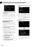
Page 53 highlights
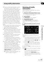
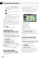
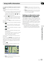
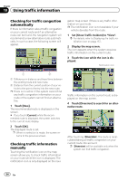
Using traffic information Chapter 10 4 Select an incident you want to view in detail. The details of the selected incident are dis- played. p Touching an incident you want to see allows you to view the detailed information of the incident. If the information cannot be dis- played on one screen, touch or to view the remaining information. p Touching allows you to check the loca- tion on a map. (Traffic information without positional information cannot be checked on a map.) # If you touch [Sort], the traffic information can be sorted. Each time you touch the key changes the setting. ! : You can sort the traffic information by the linear distance from your current position. ! : You can sort the traffic information in alpha- betical order. ! : You can sort the traffic information by the average speed. The list will be sorted in the order of closed/ blocked roads, traffic congestion, acci- dents, road works and others. Current order is indicated on the upper right of the screen. # If you touch [Refresh] while new traffic infor- mation is received, current information is chan- ged and old information is removed. The traffic information list is updated to reflect the new si- tuation. # Touch . The traffic event information displayed on the map is as follows. ! Yellow: average speed in this area is between 15 mph to 45 mph (24 km/h to 72 km/ h) ! Green: average speed in this area is faster than 45 mph (72 km/h) (An icon without a line will be displayed) Setting an alternative route to avoid traffic congestion The navigation system checks at regular intervals whether or not there is the traffic information on your route. If the navigation system detects any traffic congestion on your current route, the system tries to find a better route in the background. p The following types of traffic incidents on the route will be checked: stop and go, stopped traffic and closed/blocked roads except for closed freeway exits/entrances. Using traffic information Traffic flow icon and line ! Red: average speed in this area is slower than 15 mph (24 km/h) En 53
-
 1
1 -
2
-
3
-
4
-
5
-
6
-
7
-
8
-
9
-
10
-
11
-
12
-
13
-
14
-
15
-
16
-
17
-
18
-
19
-
20
-
21
-
22
-
23
-
24
-
25
-
26
-
27
-
28
-
29
-
30
-
31
-
32
-
33
-
34
-
35
-
36
-
37
-
38
-
39
-
40
-
41
-
42
-
43
-
44
-
45
-
46
-
47
-
 48
48 -
 49
49 -
 50
50 -
 51
51 -
 52
52 -
 53
53 -
 54
54 -
 55
55 -
 56
56 -
 57
57 -
 58
58 -
59
-
60
-
61
-
62
-
63
-
64
-
65
-
66
-
67
-
68
-
69
-
70
-
71
-
72
-
73
-
74
-
75
-
76
-
77
-
78
-
79
-
80
-
81
-
82
-
83
-
84
-
85
-
86
-
87
-
88
-
89
-
90
-
91
-
92
-
93
-
94
-
95
-
96
-
97
-
98
-
99
-
100
-
101
-
102
-
103
-
104
-
105
-
106
-
107
-
108
-
109
-
110
-
111
-
112
-
113
-
114
-
115
-
116
-
117
-
118
-
119
-
120
-
121
-
122
-
123
-
124
-
125
-
126
-
127
-
128
-
129
-
130
-
131
-
132
-
133
-
134
-
135
-
136
-
137
-
138
-
139
-
140
-
141
-
142
-
143
-
144
-
145
-
146
-
147
-
148
-
149
-
150
-
151
-
152
-
153
-
154
-
155
-
156
-
157
-
158
-
159
-
160
-
161
-
162
-
163
-
164
-
165
-
166
-
167
-
168
-
169
-
170
-
171
-
172
-
173
-
174
-
175
-
176
-
177
-
178
-
179
-
180
-
181
-
182
-
183
-
184
-
185
-
186
-
187
-
188
-
189
-
190
-
191
-
192
-
193
-
194
-
195
-
196
-
197
-
198
-
199
-
200
-
201
-
202
-
203
-
204
-
205
-
206
-
207
-
208
-
209
-
210
-
211
-
212
-
213
-
214
-
215
-
216
-
217
-
218
-
219
-
220
-
221
-
222
-
223
-
224
-
225
-
226
-
227
-
228
-
229
-
230
-
231
-
232
 |
 |