Sony Ericsson Xperia neo V User Guide - Page 102
Location services, Using GPS, Google Maps™
 |
View all Sony Ericsson Xperia neo V manuals
Add to My Manuals
Save this manual to your list of manuals |
Page 102 highlights
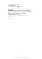
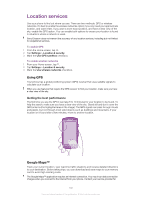
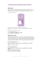
Location services Use your phone to find out where you are. There are two methods: GPS or wireless networks. It's best to enable the wireless networks option if you only need your approximate location, and want it fast. If you want a more exact position, and have a clear view of the sky, enable the GPS option. You can enable both options to ensure your location is found in situations where a network is weak. Sony Ericsson does not warrant the accuracy of any location services, including but not limited to navigational services. To enable GPS 1 From the Home screen, tap . 2 Tap Settings > Location & security. 3 Mark the Use GPS satellites checkbox. To enable wireless networks 1 From your Home screen, tap . 2 Tap Settings > Location & security. 3 Mark the Use wireless networks checkbox. Using GPS Your phone has a global positioning system (GPS) receiver that uses satellite signals to calculate your location. When you use features that require the GPS receiver to find your location, make sure you have a clear view of the sky. Getting the best performance The first time you use the GPS it can take 5 to 10 minutes for your location to be found. To help the search, make sure you have a clear view of the sky. Stand still and don't cover the GPS antenna (the highlighted area in the image). The GPS signals can pass through clouds and plastic, but not through most solid objects such as buildings and mountains. If your location isn't found after a few minutes, move to another location. Google Maps™ Track your current location, view real-time traffic situations and receive detailed directions to your destination. Before taking trips, you can download and save maps to your memory card to avoid high roaming costs. The Google Maps™ application requires an Internet connection. You may incur data connection charges when you connect to the Internet from your phone. Contact your service provider for 102 This is an Internet version of this publication. © Print only for private use.
-
 1
1 -
2
-
3
-
4
-
5
-
6
-
7
-
8
-
9
-
10
-
11
-
12
-
13
-
14
-
15
-
16
-
17
-
18
-
19
-
20
-
21
-
22
-
23
-
24
-
25
-
26
-
27
-
28
-
29
-
30
-
31
-
32
-
33
-
34
-
35
-
36
-
37
-
38
-
39
-
40
-
41
-
42
-
43
-
44
-
45
-
46
-
47
-
48
-
49
-
50
-
51
-
52
-
53
-
54
-
55
-
56
-
57
-
58
-
59
-
60
-
61
-
62
-
63
-
64
-
65
-
66
-
67
-
68
-
69
-
70
-
71
-
72
-
73
-
74
-
75
-
76
-
77
-
78
-
79
-
80
-
81
-
82
-
83
-
84
-
85
-
86
-
87
-
88
-
89
-
90
-
91
-
92
-
93
-
94
-
95
-
96
-
 97
97 -
 98
98 -
 99
99 -
 100
100 -
 101
101 -
 102
102 -
 103
103 -
 104
104 -
 105
105 -
 106
106 -
 107
107 -
108
-
109
-
110
-
111
-
112
-
113
-
114
-
115
-
116
-
117
-
118
-
119
-
120
-
121
-
122
 |
 |