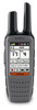
Garmin Rino 650 Owner's Manual
Garmin Rino 650 Manual
 |
View all Garmin Rino 650 manuals
Add to My Manuals
Save this manual to your list of manuals |
Garmin Rino 650 manual content summary:
- Garmin Rino 650 | Owner's Manual - Page 1
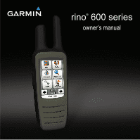
rino® 600 series owner's manual - Garmin Rino 650 | Owner's Manual - Page 2
or organization of such changes or improvements. Go to www.garmin.com for current updates and supplemental information concerning the use of this product. Garmin®, the Garmin logo, Rino®, BlueChart®, and City Navigator® are trademarks of Garmin Ltd. or its subsidiaries, registered in the USA and - Garmin Rino 650 | Owner's Manual - Page 3
Weather Alerts 12 Radio Page Status Indicators 13 Waypoints and Tracks 15 Waypoints 15 About Sharing Data 16 Rino 600 Series Owner's Manual Table of Contents Tracks 16 Navigating a Saved Track 17 Navigation 18 Navigating to a Destination 18 Map 19 Compass 19 Navigating to a Contact 21 - Garmin Rino 650 | Owner's Manual - Page 4
the Software 39 2 Viewing Device Information 39 Specifications 39 About the Batteries 40 Caring for the Device 41 Data Management 42 Additional Maps 45 Optional Accessories 45 Data Field Options 46 Troubleshooting 51 FCC Licensing Information 53 Index 54 Rino 600 Series Owner's Manual - Garmin Rino 650 | Owner's Manual - Page 5
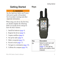
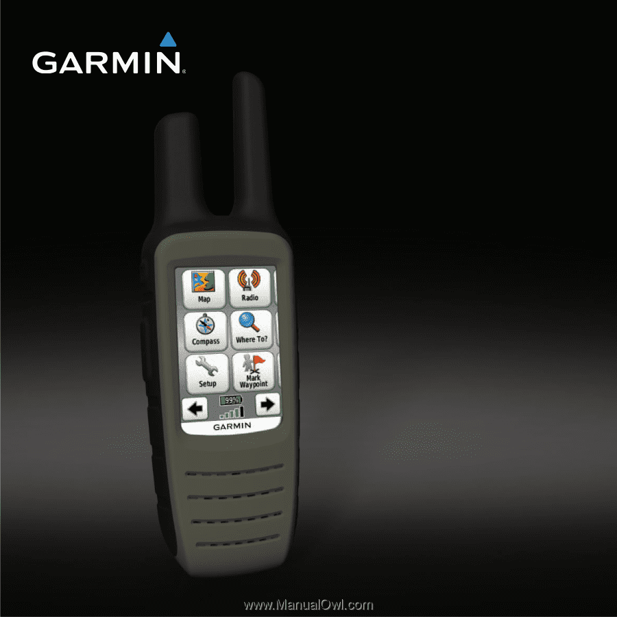
the basic features. 1. Install the batteries (page 4). 2. Register the device (page 6). 3. Acquire satellites (page 6). 4. Set up the radio (page 9). 5. Mark a waypoint (page 15). 6. Record a track (page 17). 7. Navigate to a destination (page 18). 8. Calibrate the compass (page 19). ➊ ➌ ➋ Key - Garmin Rino 650 | Owner's Manual - Page 6
-ion battery pack or four AA batteries. For tips on maximizing battery life and other battery information, see page 40. 4 2. Align the metal contacts on the battery pack with the metal contacts on the back of the device. 3. Gently press the battery pack into place. Rino 600 Series Owner's Manual - Garmin Rino 650 | Owner's Manual - Page 7
pack, you can use alkaline, NiMH, or lithium batteries. This is especially handy when you are on the trail and cannot charge the lithium-ion battery pack. Use NiMH or lithium batteries for best results. 1. Turn the D-ring counter-clockwise, and remove the cover. Rino 600 Series Owner's Manual - Garmin Rino 650 | Owner's Manual - Page 8
clockwise. 5. Update the battery type in the system settings (page 40). Acquiring Satellite Signals It may take 30 to 60 seconds to acquire signals. 1. Go outdoors to an open area. 2. Turn on the device. 6 Registering Your Device • Go to http://my.garmin.com. • Keep the original sales receipt, or - Garmin Rino 650 | Owner's Manual - Page 9
on the lithium-ion battery. This is to extend the AA battery life. 1. While the device is on, select . 2. Use + and - to adjust the brightness level. Locking the Screen note: This action does not lock the keys. 1. Select . 2. Select Lock Screen. Rino 600 Series Owner's Manual Getting Started 7 - Garmin Rino 650 | Owner's Manual - Page 10
. Select Radio > Scan. Setting Up a Scan List You can pick which channels and codes to scan. Selecting specific channels and codes reduces the scan time and helps prevent missing a transmission. 1. Select > Setup Scanlist. 2. Select a channel to add. 3. Select . 8 Rino 600 Series Owner's Manual - Garmin Rino 650 | Owner's Manual - Page 11
if a signal is going out of range. Select Radio > Monitor. Radio Settings Select > Setup Radio. • Send Location-enables you to send your current location after each transmission (page 11). • Allow Polling-enables polling. Polling allows another Rino user to get your location by sending a poll - Garmin Rino 650 | Owner's Manual - Page 12
Radio • Vox Level-Voice operated transmission controls the sensitivity level of any Vox accessory. About Contacts The first time a signal is received from another Rino user, the new contact page appears. From that page, you can show their location on the map, navigate to their location (page 21), or - Garmin Rino 650 | Owner's Manual - Page 13
also track the movement of other Rino users and navigate to their locations. Radio Enabling Peer-to-Peer Positioning Select Setup > Radio > Send Location > On. Sending a Location Before you can send a location, you must enable peer-to-peer positioning (page 11). 1. Select Share Wirelessly > Send - Garmin Rino 650 | Owner's Manual - Page 14
weather alerts are available in the US only on the Rino 650 and 655t. SAME (Specific Area Message Encoding) weather alerts allow you to receive county weather alerts on your device. 1. From the radio page, select Weather. 2. Select a channel. note: You can receive SAME weather alerts only on the - Garmin Rino 650 | Owner's Manual - Page 15
. Radio 2W Transmit power at 2 watts. Radio 5W Transmit power at 5 watts. note: If your device battery is too low, the power level is decreased automatically. The transmit power is limited to 2 watts in Canada. The maximum output power of the Rino 610 is 1 Watt. Rino 600 Series Owner's Manual - Garmin Rino 650 | Owner's Manual - Page 16
Radio Status Bar Description The radio is on. The radio is receiving. The radio is transmitting. Peer-to-peer is enabled and is ready to transmit the position. Weather alert is turned on. The radio is muted (page 8). 14 Rino 600 Series Owner's Manual - Garmin Rino 650 | Owner's Manual - Page 17
Waypoints and Tracks Waypoints Waypoints are locations you record and store in the device. Creating a Waypoint You can save your current 3. Select an item to edit. 4. Enter the new information. Rino 600 Series Owner's Manual Waypoints and Tracks 5. Select . Deleting a Waypoint 1. Select Waypoint - Garmin Rino 650 | Owner's Manual - Page 18
Receiving Data Wirelessly Before you can share data wirelessly using ANT+™ wireless technology, you must be within 10 feet (3 m) of the compatible Garmin device. 1. Select Share Wirelessly. 2. Follow the on-screen instructions to record tracks more or less often. 16 Rino 600 Series Owner's Manual - Garmin Rino 650 | Owner's Manual - Page 19
Deleting a Track 1. Select Track Manager. 2. Select a track. 3. Select Delete > Yes. Navigating a Saved Track You must record and save a track before you can navigate using it. 1. Select Track Manager. 2. Select a saved track. 3. Select View on Map. 4. Select Go. Rino 600 Series Owner's Manual 17 - Garmin Rino 650 | Owner's Manual - Page 20
can be helpful when finding your way back to camp or the trail head. 1. Select Track Manager > Current Track > View Map. 2. Select Tracback. The map page opens with your route marked with a magenta line. 3. Navigate using the map (page 19) or compass (page 19). 18 Rino 600 Series Owner's Manual - Garmin Rino 650 | Owner's Manual - Page 21
of the compass. 2. Follow the on-screen instructions. Navigating with the Bearing Pointer When navigating to a destination, the bearing pointer points to your destination, regardless of the direction you are moving. 1. Begin navigation to a destination (page 18). Rino 600 Series Owner's Manual 19 - Garmin Rino 650 | Owner's Manual - Page 22
Course Pointer Before you can navigate with the course pointer, you must change the pointer setting to Course (CDI) (page 32). 1. Begin navigation to a destination (page 18). 2. Select Compass. 3. Use the course pointer to navigate to the destination (page 20). 20 Rino 600 Series Owner's Manual - Garmin Rino 650 | Owner's Manual - Page 23
GPS coordinates posted on the Internet by those hiding the geocache. Downloading Geocaches 1. Connect your device to a computer (page 43). 2. Go to www.OpenCaching.com. 3. If necessary, create an account. 4. Sign in. Navigation 5. Follow the on-screen instructions Rino 600 Series Owner's Manual 21 - Garmin Rino 650 | Owner's Manual - Page 24
Navigation A route must contain at least two To view the point on the map, select Review. • To change the order Map 1. Select Route Planner. 2. Select a route. 3. Select View Map. Deleting a Route 1. Select Route Planner. 2. Select a route. 3. Select Delete Route. 22 Rino 600 Series Owner's Manual - Garmin Rino 650 | Owner's Manual - Page 25
(MOB) location, and start navigation back to it. 1. Select Man Overboard > Start. The map page opens with your route marked with a magenta line. 2. Navigate using the map (page 19) or compass (page 19). Stopping Navigation Select Where To? > Stop Navigation. Rino 600 Series Owner's Manual 23 - Garmin Rino 650 | Owner's Manual - Page 26
take photos with the Rino 655t. When you take a photo, the geographic location is automatically saved in the photo information. You can navigate to the location like a waypoint (page 25). Taking a Photo 1. Select Camera. 2. Turn . 2. Select a photo. 3. Select . 24 Rino 600 Series Owner's Manual - Garmin Rino 650 | Owner's Manual - Page 27
Where To? > Photos. 2. Select a photo. 3. Select Go. 4. Navigate using the map (page 19) or compass (page 19). Uploading and Downloading Photos Before you can upload photos to Garmin Connect, you must sign up for a myGarmin account. 1. Go to http://my.garmin.com, and log into your myGarmin account - Garmin Rino 650 | Owner's Manual - Page 28
settings as necessary (page 28). 2. Customize the data fields as necessary (page 26). 3. Select Setup > Profiles. 4. Select Create New Profile > OK. Editing a Profile Name 1. Select Setup > Profiles. 2. Select a profile. 3. Select Edit Name. 4. Enter the new name. 5. Select . Rino 600 Series Owner - Garmin Rino 650 | Owner's Manual - Page 29
> Data Fields. 2. Select the number of data fields to display. Rino 600 Series Owner's Manual Customizing Your Device Changing the Data Fields Before you can change the map fields, you must enable them (page 27). 1. Open the page for which you will change the data fields. 2. Select a data field to - Garmin Rino 650 | Owner's Manual - Page 30
Navigation Overlay Service), or Demo Mode (GPS off). For information about WAAS, go to www.garmin.com/aboutGPS /waas.html. • Language-sets the text language on the device. note: Changing the text language does not change the language of user-entered data or map data, such as street names. • Battery - Garmin Rino 650 | Owner's Manual - Page 31
> Tones. 2. Select a tone for each audible type. Map Settings Select Setup > Map. • Orientation-adjusts how the map is shown on the page. ◦◦ North Up-shows north at the top of the page. ◦◦ Track Up-shows your current direction of travel toward the top of the page. Rino 600 Series Owner's Manual 29 - Garmin Rino 650 | Owner's Manual - Page 32
turn information to use while driving. • Auto Zoom-automatically selects the appropriate zoom level for optimal use on your map. When Off is selected, you must zoom in or out manually. • Data Fields-page 46. • Advanced Map Setup-sets representation of your tracks. 30 Rino 600 Series Owner's Manual - Garmin Rino 650 | Owner's Manual - Page 33
based on your GPS position. Changing the Units of Measure You can customize units of measure for distance and speed, elevation, depth, temperature, and pressure. 1. Select Setup > Units. 2. Select a measurement type. 3. Select a unit of measure for the setting. Rino 600 Series Owner's Manual 31 - Garmin Rino 650 | Owner's Manual - Page 34
destination. ◦◦ Course (CDI)-your relationship to a course line leading to a destination. • Compass-switches from an electronic compass to a GPS compass when you are traveling at a higher rate of speed for a set period of time (Auto), or turns the compass off. 32 Rino 600 Series Owner's Manual - Garmin Rino 650 | Owner's Manual - Page 35
Altimeter Settings Select Setup > Altimeter. • Auto Calibration-allows the altimeter to self-calibrate each time you turn the device on. • Barometer Mode ◦◦ Variable Pressure-records ambient pressure changes over a period of time. • Calibrate Altimeter-page 34. Rino 600 Series Owner's Manual 33 - Garmin Rino 650 | Owner's Manual - Page 36
of difficulty. 34 • chirp™ Searching-turns on or off chirp searching. A chirp is a small accessory that you can program and leave in a geocache. • Program chirp™-programs the chirp accessory. See the chirp Owner's Manual at www.garmin .com. Routing Settings Select Setup > Routing. • Guidance Method - Garmin Rino 650 | Owner's Manual - Page 37
depth soundings. Simplifies map presentation for optimal use while fishing. • Appearance-allows you to set the appearance of marine navigation aids on the map. • Marine Alarm Setup ◦◦ Anchor Drag Alarm-alarm sounds when you exceed a specified drift distance while Rino 600 Series Owner's Manual 35 - Garmin Rino 650 | Owner's Manual - Page 38
, clear the current track, or restore default values. 1. Select Setup > Reset. 2. Select an item to reset. Restoring Default Settings You can reset all the setup values to the original settings. Select Setup > Reset > Reset Defaults to Factory Settings > Yes. 36 Rino 600 Series Owner's Manual - Garmin Rino 650 | Owner's Manual - Page 39
maximum speed, trip odometer, and other helpful statistics. To customize the trip computer, see page 27. Elevation Plot By default, the elevation plot displays the elevation for an elapsed of the area you want to calculate. 3. Select Calculate when finished. Rino 600 Series Owner's Manual 37 - Garmin Rino 650 | Owner's Manual - Page 40
1. Select Alarm Clock. 2. Select + and - to set the time. 3. Select Turn Alarm On. 4. Select an option. The alarm sounds at the selected time. If the device is off at the alarm time, the device turns on and sounds the alarm. Opening the Stopwatch Select Stopwatch. 38 Rino 600 Series Owner's Manual - Garmin Rino 650 | Owner's Manual - Page 41
pack (010-11599-00) or Alkaline battery pack (010-11600-00), which uses four AA batteries (alkaline, NiMH, or lithium) Up to 18 hours, typical usage using AA batteries Up to 14 hours, typical usage using the lithium-ion battery pack From 32°F to 113°F (from 0 to 45°C) Rino 600 Series Owner's Manual - Garmin Rino 650 | Owner's Manual - Page 42
you are not taking photos. • Turn the backlight off when not needed. • Lower the backlight brightness (page 7). • Decrease the backlight timeout (page 29). • Enable battery save mode (page 29). Selecting the Battery Type 1. Select Setup > System > Battery Type. 40 Rino 600 Series Owner's Manual - Garmin Rino 650 | Owner's Manual - Page 43
Rechargeable NiMH. Long-Term Storage When you do not plan to use the device for several months, remove the batteries. Stored data is not lost when batteries with the damp cloth. 3. Thoroughly dry the device. Rino 600 Series Owner's Manual Device Information Cleaning the Screen 1. Dampen a soft, - Garmin Rino 650 | Owner's Manual - Page 44
preloaded on memory cards. Go to http://buy.garmin.com for more information. 1. Turn the D-ring counter-clockwise, and remove the battery pack. 2. Slide the card holder ➊ toward the top edge of the device, and lift up, as instructed in the battery compartment. ➊ ➋ Rino 600 Series Owner's Manual - Garmin Rino 650 | Owner's Manual - Page 45
computer (page 43). 1. Browse your computer for the file. 2. Select the file. 3. Select Edit > Copy. 4. Open the "Garmin" or memory card drive/volume. TIP: You must put photo files in the Garmin\JPEG folder. You must put geocache files in the Garmin\GPX folder. Rino 600 Series Owner's Manual 43 - Garmin Rino 650 | Owner's Manual - Page 46
not be deleted. Before you can delete files, you must connect the device to your computer (page 43). 1. Open the "Garmin" drive or volume. 2. If necessary, open a folder or volume. 3. Select the files icon to the Trash . 2. Disconnect the device from your computer. Rino 600 Series Owner's Manual - Garmin Rino 650 | Owner's Manual - Page 47
, such as mounts, preloaded map memory cards, fitness accessories, and replacement parts, are available at http://buy.garmin.com or from your Garmin dealer. Optional Fitness Accessories NOTE: The fitness option is available with only the Rino 650 and 655t. Appendix Before you can use the fitness - Garmin Rino 650 | Owner's Manual - Page 48
when you turn on the Garmin device and only takes a few seconds when the accessories are activated and functioning correctly. • When paired, your Garmin device only receives data from your accessory, and you can go near other accessories. Data Field Options Data Field Accuracy of GPS Description - Garmin Rino 650 | Owner's Manual - Page 49
Data Field Barometer Battery Level Bearing Cadence (cadence accessory required) Course Depth Descent Average Description The calibrated current pressure. The remaining battery power. The direction from estimated time of day you will reach your final destination. Rino 600 Series Owner's Manual 47 - Garmin Rino 650 | Owner's Manual - Page 50
position and elevation to the destination elevation. The strength of the GPS signal. The direction you are moving. Your heart rate in in the default position format regardless of the selected settings. Displays the current position in the selected position turn. 48 Rino 600 Series Owner's Manual - Garmin Rino 650 | Owner's Manual - Page 51
GPS position. Appendix Data Field Description Temperature - The temperature of Water the water. Requires a connection to a NMEA 0183 temperature- capable device to acquire data (page 28). Time of Day The current time of day based on your time settings . Rino 600 Series Owner's Manual 49 - Garmin Rino 650 | Owner's Manual - Page 52
in degrees) between the bearing to your destination and your current course. L means turn left. R means turn right. Velocity Made The speed at which Good you are closing on a destination along destination. Waypoint at The next point on Next your route. 50 Rino 600 Series Owner's Manual - Garmin Rino 650 | Owner's Manual - Page 53
Ensure the temperature is between 32°F and 113°F (from 0 to 45°C). • Turn down the backlight (page 7). My battery gauge does 1. Leave the device on until the battery runs out. not seem accurate. 2. Fully charge the battery without interrupting the charge cycle. Rino 600 Series Owner's Manual 51 - Garmin Rino 650 | Owner's Manual - Page 54
, Windows may have trouble assigning drive letters to your Garmin drives. See the help file for your operating system to learn how to assign drive letters. I need replacement Go to http://buy.garmin.com, or contact your Garmin parts or accessories. dealer. 52 Rino 600 Series Owner's Manual - Garmin Rino 650 | Owner's Manual - Page 55
FCC Licensing Information The Rino two-way radio operates on General Mobile Radio Service(GMRS) frequencies regulated by the Federal Communications Commission (FCC) in the United States. Operation on the GMRS frequencies is subject to rules as specified in - Garmin Rino 650 | Owner's Manual - Page 56
accessories 45 wirelessly 16 contacts 10 accepting 10 editing 10 navigating 21 viewing on map 10 course pointer 20 creating routes 21 waypoints 15 customizing data fields 26 device settings 28-35 profiles 26 D dashboard 27 customizing 27 data fields 26, 27 options 46 Rino 600 Series Owner's Manual - Garmin Rino 650 | Owner's Manual - Page 57
Service (GMRS) 8 geocaches 21, 34 downloading 21 navigating 21 settings 33 GPS signals 6, 46, 48, 51 system settings 28 H heading settings 32 headset 9 HomePort 42 L language 28 locking screen 7 M man overboard 23 map 19 datum 32 detail 30 information 30 showing tracks 17 Rino 600 Series Owner - Garmin Rino 650 | Owner's Manual - Page 58
34 navigating 23 settings 34 S SAME weather alerts 12 satellite signals 6, 46, 48, 51 system settings 28 saving tracks 17 scanlist setting up 8 Sight 'N Go 23 software updating 39 version 39 specifications 39 squelch codes 8 stopwatch 38 storing the device 42 system settings 28 T text size, maps 30 - Garmin Rino 650 | Owner's Manual - Page 59
files 43 using USB 43 wirelessly 16 trip computer 37 troubleshooting 51 Z zoom 30 U unit ID 39 updating software 39 USB cable 52 connecting 43 disconnecting 44 W waypoints averaging 15 creating 15 deleting 15 editing 15 navigating to 15 weather alerts 12 Rino 600 Series Owner's Manual 57 - Garmin Rino 650 | Owner's Manual - Page 60
For the latest free software updates (excluding map data) throughout the life of your Garmin products, visit the Garmin Web site at www.garmin.com. © 2011 Garmin Ltd. or its subsidiaries Garmin International, Inc. 1200 East 151st Street, Olathe, Kansas 66062, USA Garmin (Europe) Ltd. Liberty
-
 1
1 -
 2
2 -
 3
3 -
 4
4 -
 5
5 -
 6
6 -
 7
7 -
8
-
9
-
10
-
11
-
12
-
13
-
14
-
15
-
16
-
17
-
18
-
19
-
20
-
21
-
22
-
23
-
24
-
25
-
26
-
27
-
28
-
29
-
30
-
31
-
32
-
33
-
34
-
35
-
36
-
37
-
38
-
39
-
40
-
41
-
42
-
43
-
44
-
45
-
46
-
47
-
48
-
49
-
50
-
51
-
52
-
53
-
54
-
55
-
56
-
57
-
58
-
59
-
60
 |
 |
rino
®
600 series
owner’s manual