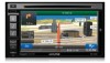
Alpine INE-W940 Owner's Manual - Navigation (english)
Alpine INE-W940 Manual
 |
View all Alpine INE-W940 manuals
Add to My Manuals
Save this manual to your list of manuals |
Alpine INE-W940 manual content summary:
- Alpine INE-W940 | Owner's Manual - Navigation (english) - Page 1
User Manual Alpine Navigation Navigation software for the Alpine INE-W940/INE-W940S/INE-NAV-40 US English January 2013, ver. 1.0 - Alpine INE-W940 | Owner's Manual - Navigation (english) - Page 2
you for choosing the Alpine unit as your navigator. Start using your device right away. This document is the detailed description of the navigation software. You can easily discover the software while you are using it; however, we still recommend that you read this manual to fully understand the - Alpine INE-W940 | Owner's Manual - Navigation (english) - Page 3
of contents 1 Warnings and Safety information 6 2 Getting started ...7 2.1 Buttons and other controls on the screen 8 2.1.1 Using keyboards...9 2.1.2 Beyond single screen tap...10 2.2 Map screen ...11 2.2.1 Navigating on the map ...11 2.2.2 Position markers...13 2.2.2.1 Vehimarker and Lock-on-Road - Alpine INE-W940 | Owner's Manual - Navigation (english) - Page 4
59 4 Off-road navigation...61 4.1 Selecting the destination of the route 61 4.2 Navigating in off-road mode...61 5 Reference Guide ...62 5.1 Concepts 67 5.3.1 Sound and Warnings ...68 5.3.2 Route settings...70 5.3.3 Map settings ...73 5.3.4 Visual guidance settings...74 5.3.5 Regional settings ... - Alpine INE-W940 | Owner's Manual - Navigation (english) - Page 5
6 Glossary...78 7 Copyright note ...80 5 - Alpine INE-W940 | Owner's Manual - Navigation (english) - Page 6
1 Warnings and Safety information The navigation system helps you find your way to your destination with a connected GPS receiver. The software does not transmit your GPS position; others cannot track you. It is important that you look at the display only when it is safe to do so. If you are - Alpine INE-W940 | Owner's Manual - Navigation (english) - Page 7
2 Getting started When using the navigation software for the first time, an initial setup process starts automatically. Do as follows: 1. Select and Warnings settings (page 76). 5. If needed, modify the time format and unit settings. Later you can change them in Regional settings (page 76). 7 - Alpine INE-W940 | Owner's Manual - Navigation (english) - Page 8
later from the Settings menu (page 67). After the initial setup, the Map screen appears and you can start using the software. 2.1 Buttons and other controls on the screen When you are using the software, you usually tap buttons on the touch screen. You only need to confirm selections or changes if - Alpine INE-W940 | Owner's Manual - Navigation (english) - Page 9
buttons to select a new value. When there are only two Tap it to turn the switch on or choices, a checkmark shows off. whether the feature is enabled. When a feature can be set to different values in a range, the software or numerical. Task Instruction Switching to another keyboard layout, - Alpine INE-W940 | Owner's Manual - Navigation (english) - Page 10
string. Entering a space, for example between a first name and a family name or in multi-word street names Entering upper and lower case letters Tap the button at the bottom center of the screen. When entering a text, the first character appears in upper case while the rest of the text is in - Alpine INE-W940 | Owner's Manual - Navigation (english) - Page 11
direction. 2.2 Map screen 2.2.1 Navigating on the map The Map screen is the most frequently used screen of the software. It shows the current position (the Vehimarker, a blue arrow by default), the recommended route (an orange line), and the surrounding map area. When there is no GPS position, the - Alpine INE-W940 | Owner's Manual - Navigation (english) - Page 12
without a given destination. Default data fields when navigating a route (tap any of the fields to reaching your final destination. Shows the time needed to reach the final destination if data is available. There are three map view modes. Tap the button below the data fields to change the view - Alpine INE-W940 | Owner's Manual - Navigation (english) - Page 13
errors, and the direction of the icon is aligned to the direction of the road. If you select off-road navigation: The Vehimarker is at your exact GPS position. The direction of the icon shows your current heading. 2.2.2.2 Selected map location (Cursor) and selected map object You can mark a map - Alpine INE-W940 | Owner's Manual - Navigation (english) - Page 14
2.2.3.2 Turn preview and Next street When navigating a route, the top section of the Map screen shows information about the next route event (maneuver) and the next street or the next city/town. There is a field in the top left - Alpine INE-W940 | Owner's Manual - Navigation (english) - Page 15
destination. These fields also act as buttons: • Tap the Turn preview field and the voice guidance will repeat the latest instruction with updated distance information. • Tap the Next street field to open the Itinerary. 2.2.3.3 Lane information and Signposts When navigating on multilane roads, it is - Alpine INE-W940 | Owner's Manual - Navigation (english) - Page 16
3D object types Your software supports the following 3D object types: Type Description 3D terrain Elevated roads 3D terrain map data shows changes in terrain, elevations or depressions in the land when you view the map in 2D, and use it to plot the route map in 3D when you navigate. Hills and - Alpine INE-W940 | Owner's Manual - Navigation (english) - Page 17
- Alpine INE-W940 | Owner's Manual - Navigation (english) - Page 18
screen with information about the selected map point, the Cursor. Tap this button to move the map back to follow the current GPS position. Automatic map rotation is also re-enabled. The map manipulation buttons disappear and navigation continues. Tap this button to open a list of additional features - Alpine INE-W940 | Owner's Manual - Navigation (english) - Page 19
on the map), tap it to open the Where Am I? screen. • In the Navigation menu, tap Information on this screen: and then . • , : Latitude and Longitude (coordinate of the current position in WGS84 format). • : Altitude (elevation information coming from the GPS receiver - often inaccurate - Alpine INE-W940 | Owner's Manual - Navigation (english) - Page 20
, avoiding parts of the route or simulating navigation. • Tap to get information about your current position, the GPS reception or the trips you have taken or to run some additional applications.. • Tap to customize the way the navigation software works. • Press the MAP hardware button to - Alpine INE-W940 | Owner's Manual - Navigation (english) - Page 21
to your route as you like. You can also use Alpine unit for off-road navigation. For details, see page 61. 3.1 Selecting the destination of a route The software offers you several ways of choosing your destination: • Enter a full address or a part of an address, for example a street name without - Alpine INE-W940 | Owner's Manual - Navigation (english) - Page 22
- Alpine INE-W940 | Owner's Manual - Navigation (english) - Page 23
at the new location. Tap destination. to confirm the destination, or tap to select a different 7. After a short summary of the route parameters, the map appears showing the entire route. The route is automatically calculated. Tap to modify route parameters, or tap and start your journey. 23 - Alpine INE-W940 | Owner's Manual - Navigation (english) - Page 24
- Alpine INE-W940 | Owner's Manual - Navigation (english) - Page 25
, tap ). b. Tap to finish entering the address. (If the entered house number cannot be found, the midpoint of the street is selected as the destination.) 25 - Alpine INE-W940 | Owner's Manual - Navigation (english) - Page 26
- Alpine INE-W940 | Owner's Manual - Navigation (english) - Page 27
• The most likely city/town name is always shown in the input field. To accept it, tap . • If the desired name does not show up, the names that match the string appear in a list after entering a couple of characters (to open the list of results before it appears automatically, tap ). Select the - Alpine INE-W940 | Owner's Manual - Navigation (english) - Page 28
- Alpine INE-W940 | Owner's Manual - Navigation (english) - Page 29
at the new location. Tap destination. to confirm the destination, or tap to select a different 6. After a short summary of the route parameters, the map appears showing the entire route. The route is automatically calculated. Tap to modify route parameters, or tap and start your journey. 29 - Alpine INE-W940 | Owner's Manual - Navigation (english) - Page 30
to the midpoint of a street if the house number is not available: 1. In the Navigation menu, tap the following buttons: , . 2. Select the country, state and city/town as described earlier (page 22). 3. Enter the street name: a. Tap (if you have selected a city/town above, this - Alpine INE-W940 | Owner's Manual - Navigation (english) - Page 31
different 6. After a short summary of the route parameters, the map appears showing the entire route. The route is automatically calculated. Tap address as the destination, do as follows: 1. In the Navigation menu, tap the following buttons: , . 2. Select the country, state and city/town as - Alpine INE-W940 | Owner's Manual - Navigation (english) - Page 32
at the new location. Tap destination. to confirm the destination, or tap to select a different 6. After a short summary of the route parameters, the map appears showing the entire route. The route is automatically calculated. Tap to modify route parameters, or tap and start your journey. 32 - Alpine INE-W940 | Owner's Manual - Navigation (english) - Page 33
- Alpine INE-W940 | Owner's Manual - Navigation (english) - Page 34
6. After a short summary of the route parameters, the map appears showing the entire route. The route is automatically calculated. name. Find below an example with a full address: 1. In the Navigation menu, tap the following buttons: , . 2. Select the country and state as described earlier ( - Alpine INE-W940 | Owner's Manual - Navigation (english) - Page 35
house number cannot be found, the midpoint of the street is selected as the destination.) 6. A full screen map appears with the selected point in the middle. If necessary, tap the map somewhere else to modify the destination. The Cursor ( ) appears at the new location. Tap destination. to - Alpine INE-W940 | Owner's Manual - Navigation (english) - Page 36
7. After a short summary of the route parameters, the map appears showing the entire route. The route is automatically calculated. Tap to modify route parameters, or tap and start your journey. 3.1.1.9 Tips on entering addresses - Alpine INE-W940 | Owner's Manual - Navigation (english) - Page 37
the Places of Interest included with your software. Using the same screen, you can Place by its name In addition, you can search for special services from the 'Where Am I?' screen. You can also search 1. To start the Quick search function, in the Navigation menu, tap , . 2. Using the keyboard, - Alpine INE-W940 | Owner's Manual - Navigation (english) - Page 38
tap . 5. Browse the list if necessary and tap one of the list items. A full screen map appears with the selected point in the middle. The name and address of the Place is displayed at the the most frequently selected types of Places. 1. In the Navigation menu, tap the following buttons: , . 38 - Alpine INE-W940 | Owner's Manual - Navigation (english) - Page 39
available either (no GPS signal), they are searched around the last known position. • : • If an active route exists, parking lots are searched around not available either (no GPS signal), they are searched around the last known position. 3. Tap any of the quick search buttons to get an instant - Alpine INE-W940 | Owner's Manual - Navigation (english) - Page 40
the list if necessary and tap one of the list items. A full screen map appears with the selected point in the middle. The name and address of the of Interest by their categories and subcategories. 1. In the Navigation menu, tap the following buttons: , . 2. Tap . 3. Select the area around - Alpine INE-W940 | Owner's Manual - Navigation (english) - Page 41
• Tap to search for a place within a selected city/town. (The result list will be ordered by the distance from the center of the selected city/town.) • Tap to search for a place around the destination of the active route. (The result list will be ordered by the distance from the destination.) - Alpine INE-W940 | Owner's Manual - Navigation (english) - Page 42
necessary detour. If you need to reorder the list, tap . 10. Browse the list if necessary and tap one of the list items. A full screen map appears with the selected point in the middle. The name and address of the Place is displayed at the top of the screen. 11. (optional - Alpine INE-W940 | Owner's Manual - Navigation (english) - Page 43
After a short summary of the route parameters, the map appears showing the entire route. The route is automatically Place database or in one Place category or subcategory only. 1. In the Navigation menu, tap the following buttons: , . 2. Tap . 3. Select the area around which the Place should - Alpine INE-W940 | Owner's Manual - Navigation (english) - Page 44
4. (optional) If you have selected , select the city/town to search in. 5. Select one of the main Place categories (e.g. Accommodation) to search in or tap to search among all Places. 6. Select one of the Place subcategories (e.g. Hotel or Motel) to search in or tap to search in the selected - Alpine INE-W940 | Owner's Manual - Navigation (english) - Page 45
necessary detour. If you need to reorder the list, tap . 11. Browse the list if necessary and tap one of the list items. A full screen map appears with the selected point in the middle. The name and address of the Place is displayed at the top of the screen. 12. (optional - Alpine INE-W940 | Owner's Manual - Navigation (english) - Page 46
is to use the free form search. Do as follows: 1. In the Navigation menu, tap . 2. Open the menu and tap . 3. In the button to see the matching items. The 6. Select one of the items from the list. 7. A full screen map appears with the selected point in the middle. If necessary, tap the map - Alpine INE-W940 | Owner's Manual - Navigation (english) - Page 47
to modify route parameters, or tap and start your journey. 3.1.4 Selecting a map location as the destination 1. In the Navigation menu, tap the following buttons: , . 2. Locate your destination on the map: move and scale the map as needed. 3. Tap the location that you want to select as your - Alpine INE-W940 | Owner's Manual - Navigation (english) - Page 48
Book is described on page 57. 1. Access the Address Book: in the Navigation menu, tap 2. The Address Book is displayed. and then tap . 3. Tap different 5. After a short summary of the route parameters, the map appears showing the entire route. The route is automatically calculated. Tap - Alpine INE-W940 | Owner's Manual - Navigation (english) - Page 49
Access the History: • If you are in the Navigation menu, tap and then tap . 2. The list The rest of the destinations are ordered by time they were last selected. If necessary, scroll After a short summary of the route parameters, the map appears showing the entire route. The route is - Alpine INE-W940 | Owner's Manual - Navigation (english) - Page 50
select a destination by entering its coordinate. Do as follows: 1. In the Navigation menu, tap . 2. Open the menu and tap . 3. You can select a different 7. After a short summary of the route parameters, the map appears showing the entire route. The route is automatically calculated. Tap to - Alpine INE-W940 | Owner's Manual - Navigation (english) - Page 51
the location stored in a picture as your destination. Do as follows: 1. In the Navigation menu, tap . 2. Open the menu and tap . 3. The list of picutres different 5. After a short summary of the route parameters, the map appears showing the entire route. The route is automatically calculated. - Alpine INE-W940 | Owner's Manual - Navigation (english) - Page 52
build your route destination by destination from the Route menu. 1. In the Navigation menu, tap . 2. Tap . 3. There is only one line in list of route points, the start point of the route, normally the current GPS position. 4. Tap to select the destination. 5. The Destination menu appears - Alpine INE-W940 | Owner's Manual - Navigation (english) - Page 53
menu, tap . 2. Tap . The active route is displayed in its full length on the map together with additional information and controls. 3.3 Modifying the route When navigation is already started, there are several ways to modify the active route. The following sections show some of those options - Alpine INE-W940 | Owner's Manual - Navigation (english) - Page 54
to check future routes, simulate them or see their length in time and distance, you can turn off the GPS receiver. Then you can set the starting point of the route to a different location than the current GPS position. 1. In the Navigation menu, tap . 2. If you already have a route, tap . If you - Alpine INE-W940 | Owner's Manual - Navigation (english) - Page 55
start point is set, tap . 6. The map returns with a transparent Vehimarker (showing that there is no GPS reception). If an active route already existed, it is now recalculated starting from the selected location. 7. To return to normal navigation, tap . 3.3.3 Editing the list of destinations - Alpine INE-W940 | Owner's Manual - Navigation (english) - Page 56
manually or you can let the application optimize the route for you. 3.3.4 Canceling the active route To cancel the navigated route, tap route is deleted with all its waypoints. in the Navigation planning method. Do as follows: 1. In the Navigation menu, tap . 2. Tap . 3. You see - Alpine INE-W940 | Owner's Manual - Navigation (english) - Page 57
one of the route alternatives then tap to return to the Map screen. The software recalculates the route. The orange line now shows the new recommended coordinate or a location where a photo was taken. 2. When the full screen map appears with the selected location in the middle, tap . 3. Tap . 4. - Alpine INE-W940 | Owner's Manual - Navigation (english) - Page 58
Tap to save the location as a new alert point. 3.6 Editing an alert point You can edit a previously saved or uploaded alert point (for example a speed camera or a railroad crossing). 1. Browse the map and select the alert point to edit. The red circle appears around the alert point. 2. Tap . 58 - Alpine INE-W940 | Owner's Manual - Navigation (english) - Page 59
Tap to save the changes to the alert point. 3.7 Watching the simulation of the route You can run a simulated navigation that demonstrates the active route. Do as follows: 1. In the Navigation menu, tap . 2. Tap . 3. Tap . The simulation starts from the starting point of the route, and using - Alpine INE-W940 | Owner's Manual - Navigation (english) - Page 60
next route event (maneuver). • : Pause the simulation. • : Jump to the previous route event (maneuver). • : Tap to increase the speed of the simulation to 4, 8 or 16 times faster. Now tap again to return to the normal speed. 2. Tap to stop the simulation. 60 - Alpine INE-W940 | Owner's Manual - Navigation (english) - Page 61
When first started, Alpine unit calculates routes using the road network of the high quality vector maps provided with the product. You can switch the application to off-road mode from the Navigation menu. Tap , , and then . Most of the procedures described for on-road navigation also apply to - Alpine INE-W940 | Owner's Manual - Navigation (english) - Page 62
5 Reference Guide On the following pages you will find the description of the different concepts and menu screens of the software. 5.1 Concepts 5.1.1 you can travel at or near the speed limit on all roads. Usually the best selection for fast and normal cars. • : Gives a route that has the - Alpine INE-W940 | Owner's Manual - Navigation (english) - Page 63
• Maneuver restrictions and directional constraints are taken into account when planning a route. • Roads are used only if access for cars is allowed. • Private roads and resident-only roads are used only if they are inevitable to reach the destination. • Walkways are excluded from routes. • : • - Alpine INE-W940 | Owner's Manual - Navigation (english) - Page 64
5.1.3 Green routing Route calculation is not only about finding the quickest or shortest route. For some of the vehicle types, you can also check the fuel consumption and CO2 emission when planning a route, and you can create cost effective routes with less effect on the environment. In Route - Alpine INE-W940 | Owner's Manual - Navigation (english) - Page 65
Audio warning: you receive a verbal warning when you exceed the speed limit with the given percentage. • Visual warning: the current speed limit is shown on the map on the map all the time. 5.1.5.1 Historical traffic If statistical traffic information is stored with the map data, the software can - Alpine INE-W940 | Owner's Manual - Navigation (english) - Page 66
help. Tap this button to open the GPS Information screen with satellite of your car even if you do not use navigation for all your journeys. Set the initial odometer value points are marked on the map. Tap the Details button to see the exact sunrise and sunset times for all your route points - Alpine INE-W940 | Owner's Manual - Navigation (english) - Page 67
can be saved manually when you reach your destination or you can turn on the automatic saving here. Modify the basic software parameters set during the initial setup process. For details, see page 7. Delete all saved data and reset all settings to their factory defaults. Visit alpine.naviextras.com - Alpine INE-W940 | Owner's Manual - Navigation (english) - Page 68
Software and Database End User License Agreement, or check the map and other contents of the application. You can also access program usage statistics. 5.3.1 Sound and Warnings Adjust to receive the information when the turn is near. Tap this button to set the verbosity of the voice instructions: - Alpine INE-W940 | Owner's Manual - Navigation (english) - Page 69
speed limit sign on the map all the time (normally it is shown only if your speed exceeds it), you can set it here. Maps may contain driver alert information. Tap this button to turn on or off these warnings and to set the distance from the hazard to receive the warning at. These can - Alpine INE-W940 | Owner's Manual - Navigation (english) - Page 70
. Button Description You can set the type of vehicle you will use to navigate the part of the route not matching your preference will be displayed in a different color on the map. software plans the best toll-free route. The software includes ferries in a planned route by default. However, a map - Alpine INE-W940 | Owner's Manual - Navigation (english) - Page 71
the following Description You can edit the parameters of the vehicle profile. Tap this button to reveal the below options. Tap this button to create your own vehicle profile. Tap this button to reset all vehicle profiles to their default settings. When creating a new vehicle profile, first you - Alpine INE-W940 | Owner's Manual - Navigation (english) - Page 72
roads, resident-only roads and walkways are excluded from routes. Route Planning Method types: Button Description Gives a quick route if you can travel at or near the speed limit on all roads. Usually the best selection for fast and normal cars. Gives a short route to minimize the distance to - Alpine INE-W940 | Owner's Manual - Navigation (english) - Page 73
can see the effect when you change a setting. Button Description Switch the map view between a 3D perspective view and two 2D top-down view modes. Adjust the basic zoom and tilt levels to your needs. Three preset levels are available. There is also a manual mode when you can set the zoom and tilt - Alpine INE-W940 | Owner's Manual - Navigation (english) - Page 74
the default visibility settings. 5.3.4 Visual guidance settings Adjust how the software helps you navigate with different kinds of route related information on the Map screen. The data fields in the corner of the Map screen can be customized. Tap this button and select the values you want to see - Alpine INE-W940 | Owner's Manual - Navigation (english) - Page 75
), you will find them in the list in case you want to bypass them with the help of the software. When enabled, the device will switch back from split screen or from Audio screen to full screen map mode during voice guidance announcements. After the voice instruction the previous screen returns. 75 - Alpine INE-W940 | Owner's Manual - Navigation (english) - Page 76
units used to display different values in the application. By default, time zone is taken from the map information and adjusted by your current location. Here you can set time zone and daylight saving manually. 5.3.6 Trip monitor settings Trip logs contain useful information about your trips - Alpine INE-W940 | Owner's Manual - Navigation (english) - Page 77
of the trips to see the trip statistics, speed and elevation profile. If track log has also been saved, you can display it on the map with the selected color. Track logs can be exported to GPX files for later use. The Trip monitor can also be accessed from the Information - Alpine INE-W940 | Owner's Manual - Navigation (english) - Page 78
or decrease the scale), you can tilt them up and down, and rotate them left and right. In GPS-supported navigation, digital maps facilitate route planning. North-up map orientation In North-up mode the map is rotated so its top always faces North. This is the orientation for example in Find on - Alpine INE-W940 | Owner's Manual - Navigation (english) - Page 79
last known) position by default. If you need to see a future route, the start point can be replaced with any other given point. Heading-up map orientation In this mode the map is rotated so its top always points in the current driving direction. This is the default orientation in 3D - Alpine INE-W940 | Owner's Manual - Navigation (english) - Page 80
without prior notification. This manual may not, in whole or in part, be reproduced or transmitted in any form either electronically or mechanically, including photocopying and recording, without the express written consent of Alpine Electronics, Inc. © 2013 - Alpine
-
 1
1 -
 2
2 -
 3
3 -
 4
4 -
 5
5 -
 6
6 -
 7
7 -
8
-
9
-
10
-
11
-
12
-
13
-
14
-
15
-
16
-
17
-
18
-
19
-
20
-
21
-
22
-
23
-
24
-
25
-
26
-
27
-
28
-
29
-
30
-
31
-
32
-
33
-
34
-
35
-
36
-
37
-
38
-
39
-
40
-
41
-
42
-
43
-
44
-
45
-
46
-
47
-
48
-
49
-
50
-
51
-
52
-
53
-
54
-
55
-
56
-
57
-
58
-
59
-
60
-
61
-
62
-
63
-
64
-
65
-
66
-
67
-
68
-
69
-
70
-
71
-
72
-
73
-
74
-
75
-
76
-
77
-
78
-
79
-
80
 |
 |

User Manual
Alpine Navigation
Navigation software for the Alpine
INE-W940/INE-W940S/INE-NAV-40
US English
January 2013, ver. 1.0