Table of Contents
Introduction
....................................................................
1
Setting Up the Astro System
......................................................
1
Device Overviews
......................................................................
1
Astro 320 Handheld Device
..................................................
1
DC 50 Dog Collar Device
......................................................
1
Keypad
..................................................................................
1
Locking the Keypad
..........................................................
1
Getting More Information
...........................................................
1
Getting the Owner's Manual
..................................................
2
Registering Your Device
.......................................................
2
Installing Batteries
......................................................................
2
Charging the Dog Collar Device
................................................
2
Turning On the Devices
.............................................................
2
Acquiring Satellite Signals
.........................................................
2
Adjusting the Backlight Brightness
.............................................
2
Fitting the Collar on Your Dog
....................................................
2
Using the On-Screen Keyboard
.................................................
2
Dog Tracking
..................................................................
3
Tracking Your Dog on the Map
..................................................
3
Navigating to Your Dog
..............................................................
3
Viewing Dog Status
...............................................................
3
Dog Status Icons
...................................................................
3
Dog Information
.........................................................................
3
Resetting a Dog's Statistics and Track
..................................
3
Changing the Length of the Dog's Track
...............................
3
Changing a Dog Name
..........................................................
3
Changing the Color of the Dog's Track
.................................
3
Changing the Dog Type
........................................................
3
Setting Dog Alerts
.................................................................
3
Removing a Dog
...................................................................
3
Adding a Dog
.............................................................................
3
Assigning a Dog ID Manually
................................................
3
About Collar Lock
.......................................................................
4
Activating Collar Lock
............................................................
4
Communication with the Collar
..................................................
4
Tracking with BaseCamp™ BaseStation
...................................
4
Waypoints, Routes, and Tracks
...................................
4
Waypoints
..................................................................................
4
Marking Your Vehicle Location
.............................................
4
Marking Your Current Location
.............................................
4
Marking a Covey
...................................................................
4
Marking a Waypoint Using the Map
......................................
4
Navigating to a Waypoint
......................................................
4
Editing a Waypoint
................................................................
4
Finding a Waypoint by Name
................................................
4
Finding a Waypoint Near Another Waypoint
.........................
4
Moving a Waypoint on the Map
.............................................
4
Repositioning a Waypoint to Your Current Location
.............
5
Increasing the Accuracy of a Waypoint Location
..................
5
Projecting a Waypoint
...........................................................
5
Deleting a Waypoint
..............................................................
5
Routes
........................................................................................
5
Creating a Route
...................................................................
5
Navigating a Saved Route
....................................................
5
Editing a Route
......................................................................
5
Viewing the Active Route
......................................................
5
Reversing a Route
................................................................
5
Deleting a Route
...................................................................
5
Deleting All Routes
................................................................
5
Tracks
........................................................................................
5
Recording Track Logs
...........................................................
5
Viewing the Elevation Plot of a Track
....................................
5
Viewing Details about the Track
............................................
5
Saving the Current Track
......................................................
6
Marking a Location on a Saved Track
...................................
6
Navigating to the Start of a Track
..........................................
6
Archiving a Track Manually
...................................................
6
Archiving Tracks Automatically
.......................................
6
Sending and Receiving Data Wirelessly
....................................
6
Sharing Dog Information
.......................................................
6
Receiving Dog Information
....................................................
6
Navigation
.......................................................................
6
Map
............................................................................................
6
Enabling the Map Data Fields
...............................................
6
Compass
....................................................................................
6
Calibrating the Compass
.......................................................
6
Navigating with the Bearing Pointer
......................................
6
Course Pointer
......................................................................
6
Find Menu
..................................................................................
7
Finding a Waypoint by Name
................................................
7
Finding a Waypoint Near Another Waypoint
....................
7
Navigating with Sight 'N Go
.......................................................
7
Viewing the Elevation Plot
.........................................................
7
Calibrating the Barometric Altimeter
.....................................
7
Navigating to a Point on the Plot
...........................................
7
Changing the Plot Type
.........................................................
7
Trip Computer
............................................................................
7
Resetting the Trip Computer
.................................................
7
Applications
...................................................................
7
Setting a Proximity Alarm
...........................................................
7
Calculating the Size of an Area
..................................................
7
Viewing the Calendar and Almanacs
.........................................
7
Setting an Alarm
........................................................................
7
Geocaches
.................................................................................
8
Downloading Geocaches
......................................................
8
Finding a Geocache
..............................................................
8
Filtering the Geocache List
...................................................
8
Editing a Custom Geocache Filter
....................................
8
Creating and Saving a Geocache Filter
...........................
8
chirp™
...................................................................................
8
Enabling chirp Searching
.................................................
8
Finding a Geocache with a chirp
......................................
8
Opening the Stopwatch
..............................................................
8
Satellite Page
.............................................................................
8
Changing the Satellite View
..................................................
8
Turning Off GPS
....................................................................
8
Simulating a Location
............................................................
8
Enabling Bark Detection
............................................................
8
Enabling Rescue Mode
..............................................................
8
Customizing Your Device
..............................................
8
Customizing the Main Menu
......................................................
8
Customizing the Data Fields
......................................................
9
Profiles
.......................................................................................
9
Creating a Custom Profile
.....................................................
9
Editing a Profile Name
..........................................................
9
Deleting a Profile
...................................................................
9
System Settings
.........................................................................
9
Dog Settings
..............................................................................
9
Display Settings
.........................................................................
9
Setting the Device Tones
...........................................................
9
Map Settings
..............................................................................
9
Advanced Map Settings
........................................................
9
Tracks Settings
..........................................................................
9
Changing the Units of Measure
...............................................
10
Time Settings
...........................................................................
10
Position Format Settings
..........................................................
10
Heading Settings
......................................................................
10
Altimeter Settings
.....................................................................
10
Table of Contents
i
 1
1 2
2 3
3 4
4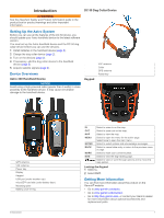 5
5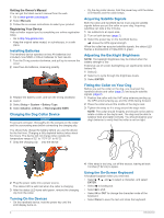 6
6 7
7 8
8 9
9

