Garmin GPSMAP 741xs Weather Supplement - Page 13
Visibility Information, Forecasting Fish Locations
 |
View all Garmin GPSMAP 741xs manuals
Add to My Manuals
Save this manual to your list of manuals |
Page 13 highlights
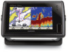
Forecasting Fish Locations NOTE: This feature is available only if you are receiving XM WX Satellite Weather data. It is not available if you are receiving only cellular weather data. You can show areas that contain optimal weather conditions for specific species of fish. 1. From the Home screen, select Information > Weather > Fishing > MENU > Fish Species. 2. Select a species of fish. 3. Select SELECT to turn display of that species of fish on or off. 4. Repeat steps 2 and 3 to show areas with optimal weather conditions for additional species of fish. Shaded areas indicate optimal fishing areas. If you have selected more than one species of fish, you can select a shaded area to view the fish species that are included in the shaded area. XM WX Satellite Weather and Cellular Weather Visibility Information NOTE: This feature is available only if you are receiving XM WX Satellite Weather data. It is not available if you are receiving only cellular weather data. Visibility is the forecast maximum horizontal distance that can be seen at the surface, as shown in the legend ➊ on the left of the screen. Variations in the visibility shading ➋ show the forecast change in surface visibility. ➊ ➋ GPSMAP 400/500 Series Weather Supplement Viewing Visibility Information From the Home screen, select Information > Weather > Visibility. 9
-
 1
1 -
2
-
3
-
4
-
5
-
6
-
7
-
 8
8 -
 9
9 -
 10
10 -
 11
11 -
 12
12 -
 13
13 -
 14
14 -
 15
15 -
 16
16 -
 17
17 -
 18
18 -
19
-
20
-
21
-
22
-
23
-
24
-
25
-
26
-
27
-
28
 |
 |
