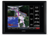
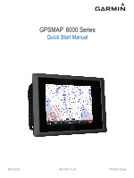
Garmin GPSMAP 8012 MFD Quick Start Manual - Page 3
Creating and Navigating a Route From Your Present, Location
 |
View all Garmin GPSMAP 8012 MFD manuals
Add to My Manuals
Save this manual to your list of manuals |
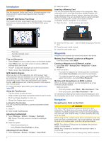
Page 3 highlights
2 If necessary, select Select. 3 Select Navigate To. 4 Select an option: • To navigate directly to the location, select Go To. • To create a route to the location, including turns, select Route To. • To use Auto Guidance, select Guide To. 5 Review the course indicated by the magenta line. NOTE: When using Auto Guidance, a gray segment within any part of the magenta line indicates that Auto Guidance cannot calculate part of the Auto Guidance line. This is due to the settings for minimum safe water depth and minimum safe obstacle height. 6 Follow the magenta line, steering to avoid land, shallow water, and other obstacles. Creating and Navigating a Route From Your Present Location You can create and immediately navigate a route on the Navigation chart or the Fishing chart. This procedure does not save the route or the waypoint data. NOTE: The offshore Fishing chart is available with premium charts, in some areas. 1 From the Navigation chart or Fishing chart, select a destination. 2 Select Navigate To > Route To. 3 Select the location of the last turn before the destination. 4 Select Add Turn. 5 If necessary, repeat step 3 and 4 to add additional turns, working backward from the destination to the present location of your vessel. The last turn you add should be the first turn you make, starting from your present location. It should be the turn closest to your vessel. 6 If necessary, select Menu. 7 Select Navigate Route. 8 Review the course indicated by the magenta line. 9 Follow the magenta line, steering to avoid land, shallow water, and other obstacles. 3
-
 1
1 -
 2
2 -
 3
3 -
 4
4
 |
 |
