Nextar X3-09 X3-09 Software Manual - Page 64
Description, Route Calculation Method types, Option, 5.4 Regional settings
 |
View all Nextar X3-09 manuals
Add to My Manuals
Save this manual to your list of manuals |
Page 64 highlights
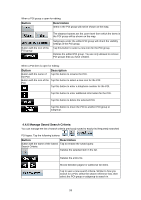
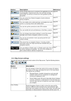
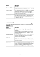
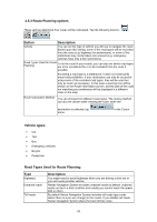
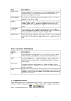
Type Charge roads Permit needed Ferries Cross-border planning Carpool lanes Description Charge roads are pay roads where you can purchase a pass or vignette to use the road for a longer period of time. They can be enabled or disabled separately from toll roads. You might need a permit or permission from the owners to use certain roads or to enter certain areas. Nextar Navigation System includes ferries in a planned route by default. However, a map does not necessarily contain information about the accessibility of temporary ferries. You might also need to pay a fare on ferries. In some cases the route calculated according to your other navigation and route preferences would lead through another country. If you wish to always stay within the same country, turn this option off. This control appears only when navigating in the USA. You should check whether you are allowed to use carpool lanes before enabling this road type. Route Calculation Method types: Option Fast Short Economical Easy Description Gives the quickest possible route if you can travel at or near the speed limit on all roads. Usually the best selection for fast and normal cars. Gives a route that has the smallest total distance of all possible routes between the route points. Usually practical for pedestrians, cyclists or slow vehicles. Combines the benefits of Fast and Short: Nextar Navigation System calculates as if it were calculating the Fast route, but it takes other roads as well to save fuel. Results in a route with fewer turns. With this option, you can make Nextar Navigation System to take, for example, the highway instead of series of smaller roads or streets. 4.5.4 Regional settings These settings allow you to customize the application for your local language, measurement units, time and date settings and formats, as well as to choose the voice guidance profile you prefer. Tap the following buttons: , , . 64
-
 1
1 -
2
-
3
-
4
-
5
-
6
-
7
-
8
-
9
-
10
-
11
-
12
-
13
-
14
-
15
-
16
-
17
-
18
-
19
-
20
-
21
-
22
-
23
-
24
-
25
-
26
-
27
-
28
-
29
-
30
-
31
-
32
-
33
-
34
-
35
-
36
-
37
-
38
-
39
-
40
-
41
-
42
-
43
-
44
-
45
-
46
-
47
-
48
-
49
-
50
-
51
-
52
-
53
-
54
-
55
-
56
-
57
-
58
-
 59
59 -
 60
60 -
 61
61 -
 62
62 -
 63
63 -
 64
64 -
 65
65 -
 66
66 -
 67
67 -
 68
68 -
 69
69 -
70
-
71
-
72
-
73
-
74
 |
 |