Garmin Alpha 200i/TT„¢ 15 Dog Tracking Bundle Owners Manual - Page 27
Garmin Alpha 200i/TT„¢ 15 Dog Tracking Bundle Manual
|
View all Garmin Alpha 200i/TT„¢ 15 Dog Tracking Bundle manuals
Add to My Manuals
Save this manual to your list of manuals |
Page 27 highlights
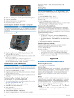
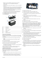
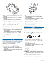
Index A accessories 18 activities 12 alarms clock 14 proximity 14 tones 15 alerts 10 dog 15 location 6 altimeter, calibrating 13 ANT+ sensors, pairing 18 applications 9, 10 area calculation 14 B backlight 17 BaseCamp 18 battery 17, 19 charging 2, 17 installing 1 life 15 maximizing 5, 11, 17 replacing 19 storage 17 beacon 11 bearing pointer 13 Bluetooth technology 9 C calibrating, altimeter 13 charging 17 collar 2 handheld 2 cleaning the device 16 cleaning the touchscreen 16 collar 5 charging 2 contact points 6 fitting 4 light 11 replacing battery 19 replacing strap 20 VHF antenna 1, 20 compass 5, 13 calibrating 13 navigating 13 computer, connecting 17, 18 contact 10 adding 10 ID 11 viewing on map 11 contact points 4, 6 covey, marking 11 D data sharing 6 sharing data 6 storing 10 transferring 10 data fields 14 deleting, all user data 18 device, care 16 display settings 15 dog 2, 4, 10, 14 adding 3 alerts 6, 15 collar 11 ID 4 information 4 navigating to 5 statistics 4, 11 track and control codes 3, 4 tracking 5, 6, 11 tracks 4, 5, 18 training 6, 7 training basics 6, 7 training intensity levels 6 type 4 update rate 17 E elevation 13 plot 13, 14 F fuse, changing 20 G Garmin Express registering the device 16 updating software 16 geofences 6 GPS 14 settings 14 H history, sending to computer 10 hunter 10 I icons 5 initial setup 2, 3 inReach 15 inReach remote 15 intensity level, choosing 6 K keys 1 training 7 L line-of-sight radio communication 5 M main menu, customizing 14 maps 11, 12 BirdsEye imagery 14 measuring distances 13 navigation 13 optional 18 orientation 13, 15 settings 15 updating 16 zoom 5, 15 measuring distances 13 memory card 1, 17 messages 7, 8, 10 deleting 8 navigating 8 microSD card. See memory card MicroSD card. See memory card N navigation 5, 13 altimeter 13 O on-screen buttons 2 P pairing ANT+ sensors 18 smartphone 9 position format 16 power cables, changing the fuse 20 power key 1, 2 product registration 16 proximity alarms 14 R radio communication 5 radio frequencies 4 registering the device 16 replacement parts 18-20 rescue mode 11 resetting the device 18 routes 12 creating 12 deleting 12 editing 12 navigating 12 settings 15 S satellite signals 2, 14 acquiring 2 settings 7, 8, 14-16 device 15 Sight 'N Go 13 sleep mode 5 smartphone 10 applications 9 pairing 9 software updates 16 updating 16 SOS 7, 8 canceling 9 sending 8, 9 specifications 16, 17 storing data 10 T tempe 15, 18 Tempe 15 temperature 18 testing the device 9 tones 15 TracBack 13 tracking 7, 8 tracks 5, 12, 13 navigating 13 recording 12 settings 15 training stimulation 6 tone 6 vibration 6 transferring, tracks 18 trip information resetting 14 viewing 14 trip planner. See routes troubleshooting 18 U units of measure 16 updates, software 16 USB connector 1 disconnecting 18 user data, deleting 18 V VHF antenna 1, 20 W waypoints 11, 13 deleting 12 editing 12 projecting 12 saving 11 weather 9 inReach 9 Wi‑Fi 9 connecting 9 Z zooming, maps 5 Index 23
-
 1
1 -
2
-
3
-
4
-
5
-
6
-
7
-
8
-
9
-
10
-
11
-
12
-
13
-
14
-
15
-
16
-
17
-
18
-
19
-
20
-
21
-
 22
22 -
 23
23 -
 24
24 -
 25
25 -
 26
26 -
 27
27 -
 28
28
 |
 |
