Garmin ECHOMAP UHD 93sv Owners Manual - Page 10
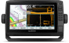
Navigation Chart and Fishing Chart
 |
View all Garmin ECHOMAP UHD 93sv manuals
Add to My Manuals
Save this manual to your list of manuals |
Page 10 highlights
If you are downloading an entire chart, you can use the Garmin Express™ app to download the map onto a memory card. The Garmin Express app downloads large charts more quickly than the ActiveCaptain app. For more information, go to garmin.com /express. NOTICE Chart updates may require the app to download large files. Regular data limits or charges from your internet service provider apply. Contact your internet service provider for more information about data limits or charges. 1 Connect the mobile device to the ECHOMAP UHD device (Getting Started with the ActiveCaptain App, page 3). 2 When a chart update is available, and you have internet access on your mobile device, select OneChart > My Charts. 3 Select the map to update. 4 Select the area to download. 5 Select Download The ActiveCaptain app downloads the update to the mobile device. When you reconnect the app to the ECHOMAP UHD device, the update is transferred to the device. After the transfer is complete, the updated charts are available for use. Charts and 3D Chart Views The charts and 3D chart views that are available depend on the map data and accessories used. NOTE: 3D chart views are available with premium charts, in some areas. You can access the charts and 3D chart views by selecting Charts. Navigation Chart: Shows navigation data available on your pre- loaded maps and from supplemental maps, if available. The data includes buoys, lights, cables, depth soundings, marinas, and tide stations in an overhead view. Fishing Chart: Provides a detailed view of the bottom contours and depth soundings on the chart. This chart removes navigational data from the chart, provides detailed bathymetric data, and enhances bottom contours for depth recognition. This chart is best for offshore deep-sea fishing. NOTE: The Fishing chart is available with premium charts, in some areas. Perspective 3D: Provides a view from above and behind the boat (according to your course) and provides a visual navigation aid. This view is helpful when navigating tricky shoals, reefs, bridges, or channels, and is beneficial when trying to identify entry and exit routes in unfamiliar harbors or anchorages. Mariner's Eye 3D: Shows a detailed, three-dimensional view from above and behind the boat (according to your course) and provides a visual navigation aid. This view is helpful when navigating tricky shoals, reefs, bridges, or channels, and when trying to identify entry and exit routes in unfamiliar harbors or anchorages. Fish Eye 3D: Provides an underwater view that visually represents the sea floor according to the chart information. When a sonar transducer is connected, suspended targets (such as fish) are indicated by red, green, and yellow spheres. Red indicates the largest targets and green indicates the smallest. Relief Shading: Provides high resolution elevation shading of lakes and coastal waters. This chart can be helpful for fishing and diving. NOTE: The Relief Shading chart is available with premium charts, in some areas. Navigation Chart and Fishing Chart NOTE: The Fishing chart is available with premium charts, in some areas. The Navigation Chart is optimized for navigation. You can plan a course, view map information, and use the chart as a navigational aid. To open the Navigation Chart, select Charts > Navigation Chart. The Fishing Chart provides a detailed view with more bottom detail and fishing content. This chart is optimized for use when fishing. To open the Fishing Chart, select Charts > Fishing Chart. Zooming In and Out of the Chart The zoom level is indicated by the scale number at the bottom of the chart. The bar under the scale number represents that distance on the chart. • To zoom out, select or pinch two fingers together on the touchscreen. • To zoom in, select or spread two fingers apart on the touchscreen. Panning the Chart with the Keys You can move the chart to view an area other than your present location. 1 From the chart, use the arrow keys. 2 Select BACK to stop panning and return the screen to your present location. NOTE: To pan from a combination screen, select SELECT. Selecting an Item on the Map Using the Device Keys 1 From a chart or 3D chart view, select , , , or to move the cursor. 2 Select SELECT. Chart Symbols This table contains some of the common symbols you might see on the detailed charts. Icon Description Buoy Information Marine services Tide station Current station Overhead photo available Perspective photo available Other features common to most charts include depth contour lines, intertidal zones, spot soundings (as depicted on the original paper chart), navigational aids and symbols, obstructions, and cable areas. Measuring a Distance on the Chart 1 From a chart, select a location. 2 Select Measure Distance. 4 Charts and 3D Chart Views
-
 1
1 -
2
-
3
-
4
-
 5
5 -
 6
6 -
 7
7 -
 8
8 -
 9
9 -
 10
10 -
 11
11 -
 12
12 -
 13
13 -
 14
14 -
 15
15 -
16
-
17
-
18
-
19
-
20
-
21
-
22
-
23
-
24
-
25
-
26
-
27
-
28
-
29
-
30
-
31
-
32
-
33
-
34
-
35
-
36
-
37
-
38
-
39
-
40
-
41
-
42
-
43
-
44
-
45
-
46
-
47
-
48
-
49
-
50
-
51
-
52
 |
 |
