Garmin GDL 84 Pilots Guide - Page 30
Fis-b Nexrad
 |
View all Garmin GDL 84 manuals
Add to My Manuals
Save this manual to your list of manuals |
Page 30 highlights
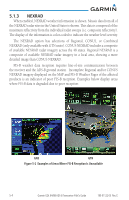
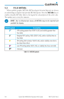
WARNING: Do not use the indicated data link weather product age to determine the age of the weather information shown by the data link weather product. Due to time delays inherent in gathering and processing weather data for data link transmission, the weather information shown by the data link weather product may be significantly older than the indicated weather product age. WARNING: Weather data received by the GDL 84 may be displayed on personal electronic devices, such as tablets, via Flight Stream. This information merely supplemental and advisory in nature and is not intended to be relied upon for safety-critical operations. 5.1 FIS-B NEXRAD WSR-88D weather surveillance radar or NEXRAD (NEXt generation RADar) is a Doppler radar system that has greatly improved the detection of meteorological events such as thunderstorms, tornadoes, and hurricanes. An extensive network of NEXRAD stations provides almost complete radar coverage of the continental United States, Alaska, and Hawaii. The unobstructed range of each NEXRAD is 124 nautical miles. FIS-B is a graphic weather display overlaid on the map indicating the rainfall detected by ground based radar for a specific area. Colors are used to identify the different NEXRAD echo intensities (reflectivity) measured in dBZ, decibels of reflectivity (Z). "Reflectivity" is the amount of transmitted power returned to the radar receiver. The dBZ values increase as returned signal strength increases. Precipitation intensity is displayed using colors corresponding to the dBZ values. An example of how precipitation data is color coded follows: Figure 5-1 Sample FIS-B Weather Precipitation Legend 5-2 Garmin GDL 84/88 ADS-B Transceiver Pilot's Guide 190-01122-03 Rev. E
-
 1
1 -
2
-
3
-
4
-
5
-
6
-
7
-
8
-
9
-
10
-
11
-
12
-
13
-
14
-
15
-
16
-
17
-
18
-
19
-
20
-
21
-
22
-
23
-
24
-
 25
25 -
 26
26 -
 27
27 -
 28
28 -
 29
29 -
 30
30 -
 31
31 -
 32
32 -
 33
33 -
 34
34 -
 35
35 -
36
-
37
-
38
-
39
-
40
-
41
-
42
-
43
-
44
-
45
-
46
-
47
-
48
-
49
-
50
-
51
-
52
 |
 |
