Garmin GPS V Deluxe Brochure - Page 2
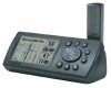
GPS V - receiver
 |
View all Garmin GPS V Deluxe manuals
Add to My Manuals
Save this manual to your list of manuals |
Page 2 highlights
GPS V specifications Navigation features Waypoints/icons: 500 with name and graphic symbol, 10 nearest (automatic), 10 proximity Routes: Automatic turn-by-turn routes; 20 manual point-to-point routes with up to 50 points each. Tracks: Automatic track log; 10 saved tracks let you retrace your path in both directions Trip computer: Resettable odometer, timers, average and maximum speeds Alarms: Anchor drag, approach and arrival, off course and proximity waypoint Tables: Built-in celestial tables for best times to fish and hunt, sun and moon rise/set based on date and location Map datums: More than 100, plus user datum Position format: Lat/Lon, UTM/UPS, Maidenhead, MGRS, Loran TDs and other grids, including user grid GPS performance Receiver: WAAS enabled, 12 parallel channel GPS receiver continuously tracks and uses up to 12 satellites to compute and update your position Acquisition times: Warm: Cold: AutoLocate™: Approximately 15 seconds Approximately 45 seconds Approximately 5 minutes Update rate: 1/second, continuous GPS accuracy: Position: Velocity: < 15 meters, 95% typical* 0.05 meter/sec steady state DGPS (USCG) accuracy: Position: 3-5 meters, 95% typical Velocity: 0.05 meter/sec steady state DGPS (WAAS) accuracy: Position: < 3 meters, 95% typical Velocity: 0.05 meter/sec steady state Dynamics: 6g's Interfaces: RS232 with NMEA 0183, RTCM 104 DGPS data format and proprietary GARMIN Antenna: Detachable with standard BNC connector Differential: RTCM-104, WAAS Moving map features Basemap: Built-in routable basemap (North and South America) with cities, highways, interstates, local thoroughfares and secondary roads within metro areas, interstate exit services, airports, rivers, lakes and coastlines Uploadable maps: Accepts up to 19 megabytes of downloaded detail from included CD. Other compatible MapSource™ CDs** offer topographic maps, fishing information, routable street-level detail, addresses, listings of restaurants, hotels and more. Power Source: Battery life: 8-35v DC, 4 "AA" batteries (not included) Up to 25 hours Physical Size: Weight: Display: Case: Temperature range: User data storage: 5.0"W x 2.3"H x 1.6"D (12.7 x 5.9 x 4.1 cm) 9 ounces (255 g) w/batteries 2.2"W x 1.5"H (5.6 x 3.8 cm), 256 x 160 pixels, high-contrast FSTN with bright backlighting. Switchable orientation. Fully gasketed, high-impact plastic alloy, waterproof to IEC 529 IPX7 standards 5˚ F to 158˚ F (-15˚ C to 70˚ C) Indefinite, no memory battery required Accessories Standard: Optional: PC interface cable MapSource™ City Select™ CD Automotive mount 12-volt adapter cable Wrist strap Owner's manual Quick start guide Handlebar mount Bean bag mount Swivel mount Carrying case Remote GPS antenna PC interface cable with 12-volt adapter AC/PC adapter Power/data cable Additional MapSource™ CD-ROMs Instructional video The GPS V can automatically create a route and display turn-by-turn directions to your destination. A highlighted route line and arrows guide you through upcoming turns. You can even use the GPS V to look up services at U.S. interstate exits. ©2001 GARMIN Corporation GARMIN International 1200 East 151st Street Olathe, Kansas 66062, U.S.A. 913/397.8200 fax 913/397.8282 GARMIN (Europe) Ltd. Unit 5, The Quadrangle Abbey Park Industrial Estate Romsey, SO51 9AQ, U.K. 44/1794.519944 fax 44/1794.519222 GARMIN (Asia) Corporation No. 68, Jangshu 2nd Rd. Shijr, Taipei County, Taiwan 886/2.2642.9199 fax 886/2.2642.9099 www.garmin.com REV1101 M02-10056-00 Specifications are preliminary and subject to change without notice. * Subject to accuracy degradation to 100m 2DRMS under the U.S. Department of Defense imposed Selective Availability Program. **Also able to transfer waypoints, routes and tracks between the PC and GPS using MapSource.
-
 1
1 -
 2
2
 |
 |
