Garmin GPSMAP 421s Owner's Manual - Page 79
Index
 |
View all Garmin GPSMAP 421s manuals
Add to My Manuals
Save this manual to your list of manuals |
Page 79 highlights
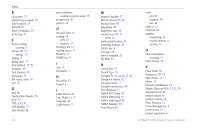
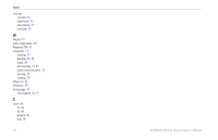
Index Index A A-scope 59 Active Tracks 15 aerial photos 19 AIS 41, 42, 54, 65 targeting symbols 42 threats 42 AIS Alarm 55 alarms 52, 68-71 AIS 55 anchor drag 52 battery 52 clock 52 collision 55 deep water 53 engine gauge 33 fish 53 fuel 53 GPS accuracy 52 navigation 52 off course 52 safe-zone 55 shallow water 53 sonar 53 water temp 53 Animated 11 apparent wind 36 Appearance 59 arrival alarms 52 Auto Magnetic 48 automatic guidance 21, 49 autopilot 30 Auto Power 47 B backing up data 40 backlight adjusting 3 barometer, reference time 48 Beeper/Display 47 BlueChart g2 Vision using 30-34 boat icon 13 bottom lock 60 buttons 4 C Calibrate Water Speed 54 celestial 38 Chart/Sonar screen using 22 Chart Borders 13 chart data 9 charts detail 12 fish eye 3D 17 fishing 17 mariner's eye 3D 15 navigation 7 settings 11 Clear User Data 39 collision alarm 55 colors, hazard 16 Color Scheme 60 Communications 50 Compass 31 compass rose 12 Compass Tape 9 contact information, Garmin iv coordinates, grid creating waypoints using 25 course up 12 current stations 38 customizing chart settings 11 D Dashboard 31 data transfer 40 Data Bars fish eye 3D chart 17 Navigation chart 8 perspective 3D chart 15 sailing 9 sonar 59 Data Transfer 39 daylight saving time 48 Declaration of Conformity iv delete a waypoint 26 depth line 59 Depth Log 58 depth waypoint 60 detail 12 details, AIS vessels 44 Device List 51 Display 47 distance, measuring 26 Distress Calls 62 DSC 54, 61 contact 62 list 62 DST 48 GPSMAP 400/500 Series Owner's Manual 73
-
 1
1 -
2
-
3
-
4
-
5
-
6
-
7
-
8
-
9
-
10
-
11
-
12
-
13
-
14
-
15
-
16
-
17
-
18
-
19
-
20
-
21
-
22
-
23
-
24
-
25
-
26
-
27
-
28
-
29
-
30
-
31
-
32
-
33
-
34
-
35
-
36
-
37
-
38
-
39
-
40
-
41
-
42
-
43
-
44
-
45
-
46
-
47
-
48
-
49
-
50
-
51
-
52
-
53
-
54
-
55
-
56
-
57
-
58
-
59
-
60
-
61
-
62
-
63
-
64
-
65
-
66
-
67
-
68
-
69
-
70
-
71
-
72
-
73
-
 74
74 -
 75
75 -
 76
76 -
 77
77 -
 78
78 -
 79
79 -
 80
80 -
 81
81 -
 82
82 -
 83
83 -
 84
84
 |
 |