Garmin GPSMAP 431/431s Owner's Manual - Page 63
Using Sonar, Understanding the Full Screen - gpsmap 431 fishfinder
 |
View all Garmin GPSMAP 431/431s manuals
Add to My Manuals
Save this manual to your list of manuals |
Page 63 highlights
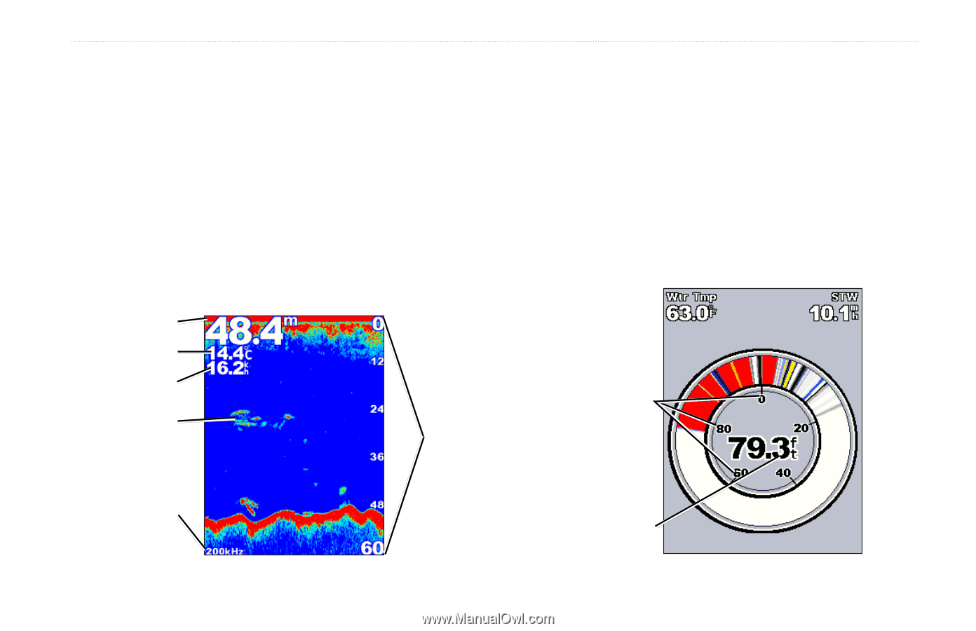
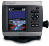
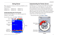
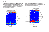
Using Sonar When connected to a transducer, the following chartplotters can be used as fishfinders: GPSMAP 431s GPSMAP 441s GPSMAP 531s GPSMAP 536s GPSMAP 541s GPSMAP 546s Understanding the Full Screen Select the Full Screen option to view a full-screen graph of the transducer's sonar readings. From the Home screen, select Sonar > Full Screen. Depth Temperature Speed Suspended targets Range Using Sonar Understanding the Flasher Screen (GPSMAP 431s/531s/536s only) Use the Flasher screen to display sonar information on a circular depth scale. The scale indicates what is beneath your boat. It is organized as a ring that starts at the top and progresses clockwise. Sonar information flashes on the ring when it is received at the depth indicated. The colors indicate different strengths of the sonar return. (When using the white default color scheme, red indicates the strongest return, blue indicates the weakest return, and white indicates no return.) From the Home screen, select Sonar > Flasher. Depth of sonar readings Transducer frequency or beam width Full Screen GPSMAP 400/500 Series Owner's Manual Water depth at current location Flasher 57
-
 1
1 -
2
-
3
-
4
-
5
-
6
-
7
-
8
-
9
-
10
-
11
-
12
-
13
-
14
-
15
-
16
-
17
-
18
-
19
-
20
-
21
-
22
-
23
-
24
-
25
-
26
-
27
-
28
-
29
-
30
-
31
-
32
-
33
-
34
-
35
-
36
-
37
-
38
-
39
-
40
-
41
-
42
-
43
-
44
-
45
-
46
-
47
-
48
-
49
-
50
-
51
-
52
-
53
-
54
-
55
-
56
-
57
-
 58
58 -
 59
59 -
 60
60 -
 61
61 -
 62
62 -
 63
63 -
 64
64 -
 65
65 -
 66
66 -
 67
67 -
 68
68 -
69
-
70
-
71
-
72
-
73
-
74
-
75
-
76
-
77
-
78
-
79
-
80
-
81
-
82
-
83
-
84
-
85
-
86
-
87
-
88
-
89
-
90
-
91
-
92
-
93
-
94
-
95
-
96
 |
 |