Garmin GPSMAP 5008 Owner's Manual - Page 59
Alarms and Messages, Approaching Waypoint <name>, Arrival Alarm <name> - software update
 |
UPC - 753759066079
View all Garmin GPSMAP 5008 manuals
Add to My Manuals
Save this manual to your list of manuals |
Page 59 highlights
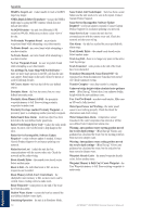
Alarms and Messages Accuracy Alarm (GPS)-the GPS accuracy has fallen outside the user-set value. AIS: Dangerous Target-an AIS target presents a collision threat. Alarm Clock-the alarm clock has sounded. Anchor Drag Alarm-the boat has drifted out of the userset distance range. Antenna Input is Shorted-there is a short in the wiring to the GPS 17 antenna. Approaching Waypoint -the boat is a specified alarm distance from the destination waypoint. Arrival Alarm -arriving at destination waypoint. Auto-guidance unable to calculate route-(BlueChart g2 Vision) auto-guidance cannot calculate the route. Auto-guidance unable to calculate route, please shorten route-(BlueChart g2 Vision) auto-guidance cannot calculate the route, select a closer end point. Auto-guidance unable to calculate route. Starting position not within safe depth-(BlueChart g2 Vision) auto-guidance cannot calculate the route; boat is not in a safe depth. Auto-guidance unable to calculate route. Ending position not within safe depth-(BlueChart g2 Vision) auto-guidance cannot calculate the route; select an end point within the specified safe depth Battery Alarm-Battery voltage is at or below the user-set value. Boat is not Moving Fast Enough to Calibrate-(speed sensor) appears during water-speed calibration. Check speed wheel for blockage and calibrate again. If wheel is clear, calibrate again and increase speed. Can't Read User Card-cannot read card when attempting a user data transfer. Can't Read Voltages That High, Limited To Top Of Range-entering a battery-alarm voltage higher than the unit can read. Can't Read Voltages That Low, Limited To Bottom Of Range-entering a battery-alarm voltage lower than the unit can read. Can't Unlock Maps-maps are locked and cannot be used on this unit. Can't Write User Card-cannot write card when attempting a user data transfer. Cartography Service Incompatible. Software Update Required-a software update is needed. Contact Garmin Product Support for assistance updating your unit software. Cooling Fan Voltage Too High-the cooling-fan voltage is higher than expected. Contact product support. Cooling Fan Voltage Too Low-the cooling-fan voltage is lower than expected. Contact product support. Database Error-general database error. Contact Garmin Product Support. GPSMAP® 4000/5000 Series Owner's Manual Appendix Deep Water Alarm-(sonar) the boat has entered userdefined value for deep water. Directory Item With This MMSI Already Exists-the MMSI unit is already in directory. Directory Memory is Full Can't Create Entry-DSC directory is full, no more entries can be created. Distress Call Received From -A distress call has been received by the DSC module. Drift Alarm-the boat has moved a user-defined distance. DSC Position Report Received From -a position report has been received by the DSC module. Entering Target Water Temperature-(temperature sensor/transducer) the water temperature is inside the userdefined target temperature zone. GPS Antenna Has Lost Its Stored Settings-The GPS antenna memory has been cleared. Contact Garmin Product Support. GPS Service Incompatible. Software Update Required-a GPS service software update is needed. Contact Garmin Product Support for assistance updating your unit software. GPS Service Lost-the unit has lost communications with the remote GPS unit. Check the network and the antenna wiring. Incompatible Device, Software Update Required-an incompatible device is attached that requires a software update. Contact Garmin Product Support for assistance updating your network. Invalid Device Instance. Enter a number between (0 - 252)-invalid NMEA 2000 Device instance. Invalid Entry. Default value selected.-an invalid entry was entered. Invalid MMSI-an invalid DSC MMSI was entered. Invalid System Instance. Enter a number between (0 - 15)-invalid NMEA 2000 System instance. Leaving Target Water Temperature-(temperature sensor/transducer) the water temperature is outside the user-defined target temperature zone Low Fuel Alarm-(NMEA 2000) low fuel reported by the NMEA 2000 network. Lost Heading Sensor Connection- (radar/NMEA) the unit has lost communications with the heading sensor. Check wiring. Lost Remote GPS Connection-connection to the remote GPS has been lost. Check the network and the antenna wiring. Lost Satellite Reception-the unit has lost satellite reception. Make sure you have a clear view of the sky. Map Format Is Not Supported-a map format on a preprogrammed SD card is not supported. MARPA: Dangerous Target-(radar) a MARPA target has become dangerous. 55 Appendix
-
 1
1 -
2
-
3
-
4
-
5
-
6
-
7
-
8
-
9
-
10
-
11
-
12
-
13
-
14
-
15
-
16
-
17
-
18
-
19
-
20
-
21
-
22
-
23
-
24
-
25
-
26
-
27
-
28
-
29
-
30
-
31
-
32
-
33
-
34
-
35
-
36
-
37
-
38
-
39
-
40
-
41
-
42
-
43
-
44
-
45
-
46
-
47
-
48
-
49
-
50
-
51
-
52
-
53
-
 54
54 -
 55
55 -
 56
56 -
 57
57 -
 58
58 -
 59
59 -
 60
60 -
 61
61 -
 62
62 -
 63
63 -
 64
64 -
65
-
66
-
67
-
68
 |
 |