Garmin GPSMAP 541s Installation Instructions - Page 10
Physical Specifications, Performance, Power - w o transducer
 |
UPC - 753759096045
View all Garmin GPSMAP 541s manuals
Add to My Manuals
Save this manual to your list of manuals |
Page 10 highlights
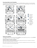
To test the transom mount transducer installation: 1. Begin testing the installation at a slow speed. If the sonar appears to be working properly, gradually increase the speed of the boat while observing the operation of the sonar. If the sonar signal suddenly is lost or the bottom return is severely degraded, note the speed at which this occurs. 2. Return the boat to the speed at which the signal was lost. Make moderate turns in both directions to see if the signal improves. 3. If the signal strength improves while turning, adjust the transducer so that it extends another 1/8 in. below the transom of the boat. It might take several adjustments to eliminate the degradation. 4. If the signal does not improve, you might have to move the transducer to a different location. Caution: When adjusting the depth of the transducer, make the adjustments in small increments. Placing the transducer too deep can adversely affect the performance of the boat and put the transducer at greater risk of striking underwater objects. Specifications Physical Specifications Size : 400 Series: W × H × D: 5.7 × 5.0 . × 3.0 in. (14.5 × 12.7 × 7.6 cm) 500 Series: W × H × D: 5.9 × 6.4 × 2.9 in. (15.0 × 16.3 × 7.4 cm) Weight: 400 Series: 1.30 lb. (560 g) 500 Series: 1.75 lb. (800 g) Display: GPSMAP 420/421/430/431/440/441/450/451 (s): 4.0 in. diagonal (10.6 cm), QVGA display with adjustable brightness, 320 × 240 pixels. GPSMAP 520/521/530/531/540/541/550/551 (s): 5.0 in. diagonal (12.7 cm), QVGA display with adjustable brightness, 320 × 234 pixels. GPSMAP 525/526/535/536/545/546/555/556 (s): 5.0 in. diagonal (12.7 cm), Full VGA display with adjustable brightness, 640 × 480 pixels, capable of 4,096 colors. Case: Fully gasketed, high-impact plastic alloy, waterproof to IEC 529 IPX7 standards. Temp. Range: From 5ºF to 131ºF (from -15ºC to 55ºC) Compass-Safe Distances: Model Number GPSMAP 526/536/546/556 GPSMAP 421/431/441/451 GPSMAP 521/531/541/551 GPSMAP 420/430/440/450 GPSMAP 520/530/540/550/525/535/545/555 Compass-Safe Distance 20 in. (50 cm) 26 in. (65) cm 30 in. (75 cm) 38 in. (95 cm) Performance Receiver: GPSMAP 420/430/440/450 (s) GPSMAP 520/530/540/550/525/535/545/555 (s): Differential-ready 12 parallel channel WAAS-capable receiver GPSMAP 421/431/441/451 (s) GPSMAP 521/531/541/551 (s): High-sensitivity 14 parallel channel WAAS-capable receiver. GPSMAP 526/536/546/556 (s): High-sensitivity 12 parallel channel WAAS-capable receiver. Acquisition Times: (Average acquisition times for a stationary receiver with a clear view of the sky.) GPSMAP 420/430/440/450 (s) GPSMAP 520/530/540/550/525/535/545/555 (s): Warm*: Approximately 15 seconds Cold**: Approximately 45 seconds GPSMAP 421/431/441/451 (s) GPSMAP 521/526/531/536/541/546/551/556 (s): Warm*: Approximately 1 second Cold**: Approximately 38 seconds *Warm: your unit is at or near the last location where you recently acquired satellites. **Cold: your unit has moved by more than about 500 mi. (800 km) since it was turned off. Update Rate: 1/second, continuous GPS Accuracy: Position:
-
 1
1 -
2
-
3
-
4
-
 5
5 -
 6
6 -
 7
7 -
 8
8 -
 9
9 -
 10
10 -
 11
11 -
 12
12
 |
 |