Garmin GPSMAP 78s Owner's Manual - Page 28
Data Field, Description
 |
View all Garmin GPSMAP 78s manuals
Add to My Manuals
Save this manual to your list of manuals |
Page 28 highlights
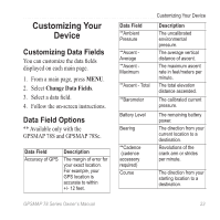
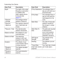
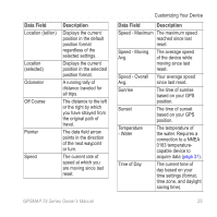
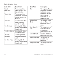
Customizing Your Device Data Field Depth **Descent - Average **Descent - Maximum **Descent - Total Distance to Dest. Distance to Next Elevation **Elevation - Maximum **Elevation - Minimum Description The depth of the water. Requires a connection to a NMEA 0183 depth-capable device to acquire data (page 27). The average vertical distance of descent. The maximum descent rate in feet/meter per minute. The total elevation distance descended. The distance to your final destination. The remaining distance to the next waypoint on the route. The altitude of your current location above or below sea level. The highest elevation reached. The lowest elevation reached. Data Field Description ETA at Destination The estimated time of day you will reach your final destination. ETA at Next The estimated time of day you will reach the next waypoint on the route. Glide Ratio The ratio of horizontal distance traveled to the change in vertical distance. Glide Ratio To Dest. The glide ratio required to descend from your current position and elevation to the destination elevation. GPS Signal Strength The strength of the GPS signal. Heading The direction you are moving. **Heart Rate Your heart rate in beats (heart rate monitor per minute (bpm). required) 24 GPSMAP 78 Series Owner's Manual
-
 1
1 -
2
-
3
-
4
-
5
-
6
-
7
-
8
-
9
-
10
-
11
-
12
-
13
-
14
-
15
-
16
-
17
-
18
-
19
-
20
-
21
-
22
-
 23
23 -
 24
24 -
 25
25 -
 26
26 -
 27
27 -
 28
28 -
 29
29 -
 30
30 -
 31
31 -
 32
32 -
 33
33 -
34
-
35
-
36
-
37
-
38
-
39
-
40
-
41
-
42
-
43
-
44
-
45
-
46
-
47
-
48
-
49
-
50
-
51
-
52
-
53
-
54
-
55
-
56
 |
 |