Garmin GTN 725 STC GTN 6XX/7XX AFMS - Page 30
Traffic System Optional, StormScope, Optional
 |
View all Garmin GTN 725 manuals
Add to My Manuals
Save this manual to your list of manuals |
Page 30 highlights
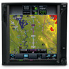
GARMIN Ltd. or its Subsidiaries, c/o Garmin International 1200 E. 151st Street Olathe, KS 66062 USA AIRPLANE FLIGHT MANUAL SUPPLEMENT or SUPPLEMENTAL AIRPLANE FLIGHT MANUAL for STC SA02019SE-D GARMIN GTN NAVIGATION SYSTEM 7.7 Traffic System (Optional) This system is configured for the following type of traffic system. The Garmin GTN 6XX or GTN 7XX Cockpit Reference Guide or Garmin GTN 6XX or GTN 7XX Pilot's Guide provides additional information regarding the functionality of the traffic device. … No traffic system is interfaced to the GTN. … A TAS/TCAS I traffic system is interfaced to the GTN. … A TIS traffic system is interfaced to the GTN. 7.8 StormScope® (Optional) When optionally interfaced to a StormScope® weather detection system, the GTN may be used to display the StormScope® information. Weather information supplied by the StormScope® will be displayed on the StormScope® page of the GTN system. For detailed information about the capabilities and limitations of the StormScope® system, refer to the documentation provided with that system. Heading Up mode: If the GTN system is receiving valid heading information, the StormScope® page will operate in the heading up mode as indicated by the label "HDG UP" presented at the upper right corner of the display. In this mode, information provided by the StormScope® system is displayed relative to the nose of the aircraft and is automatically rotated to the correct relative position as the aircraft turns. Track Up mode: If the GTN system is not receiving valid heading information, either because a compatible heading system is not installed, or the interfaced heading system has malfunctioned, the StormScope® page will operate in the track up mode as indicated by the label "TRK UP" in the upper right corner of the display. When operating in the track up mode, StormScope® information is displayed relative to the current GPS track of the aircraft and is automatically rotated as the aircraft turns. In track up mode, the pilot must be aware that, if the combination of aircraft speed and crosswind results in a crab angle to maintain the track, the relative bearing of StormScope® information on the GTN display will be offset by an amount equal to the aircraft crab angle. Because the difference between GPS track and aircraft heading can be very large when on the ground, use of the GTN to display StormScope® information in TRK UP mode is prohibited while on the ground. 190-01007-A2 Rev. 1 FAA APPROVED DATE: _M__A_R_C_H__1_8__,_2_0_1_1__ Page 30 of 31
-
 1
1 -
2
-
3
-
4
-
5
-
6
-
7
-
8
-
9
-
10
-
11
-
12
-
13
-
14
-
15
-
16
-
17
-
18
-
19
-
20
-
21
-
22
-
23
-
24
-
 25
25 -
 26
26 -
 27
27 -
 28
28 -
 29
29 -
 30
30 -
 31
31
 |
 |
