Garmin GXM 30 GXM 30 Owner's Manual for Marine/Aviation Products - Page 37
NEXRAD Overview, NEXRAD Description, NEXRAD Abnormalities, NEXRAD Limitations
 |
UPC - 753759047955
View all Garmin GXM 30 manuals
Add to My Manuals
Save this manual to your list of manuals |
Page 37 highlights
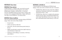
NEXRAD Overview NEXRAD Description NEXRAD Radar is a Doppler radar system that has greatly improved the detection of meteorological events such as thunderstorms, tornadoes, and hurricanes. An extensive network of NEXRAD stations provides almost complete radar coverage of the continental United States, Alaska, and Hawaii. The range of each NEXRAD is 124 nautical miles. NEXRAD Abnormalities There are possible abnormalities regarding displayed NEXRAD images. Some, but not all, of those include: • Ground clutter • Strobes and spurious radar data • Sun strobes, when the radar antenna points directly at the sun • Military aircraft deploy metallic dust (chaff) which can cause alterations in radar scans • Interference from buildings or mountains, which may cause shadows GXM 30 XM Radio Smart Antenna Owner's Manual APPENDIX > NEXRAD OVERVIEW NEXRAD Limitations Certain limitations exist regarding the NEXRAD radar displays. Some, but not all, are listed for the user's awareness: • NEXRAD base reflectivity does not provide sufficient information to determine cloud layers or precipitation characteristics (hail vs. rain). • NEXRAD base reflectivity is sampled at the minimum antenna elevation angle. An individual NEXRAD site cannot depict high altitude storms at close ranges, and has no information about storms directly over the site. 30
-
 1
1 -
2
-
3
-
4
-
5
-
6
-
7
-
8
-
9
-
10
-
11
-
12
-
13
-
14
-
15
-
16
-
17
-
18
-
19
-
20
-
21
-
22
-
23
-
24
-
25
-
26
-
27
-
28
-
29
-
30
-
31
-
 32
32 -
 33
33 -
 34
34 -
 35
35 -
 36
36 -
 37
37 -
 38
38 -
 39
39 -
 40
40 -
 41
41 -
 42
42 -
43
-
44
-
45
-
46
-
47
-
48
 |
 |
