Garmin Oregon 200 Owner's Manual - Page 20
navigating on water or where there, This is most useful if you are
 |
UPC - 753759078553
View all Garmin Oregon 200 manuals
Add to My Manuals
Save this manual to your list of manuals |
Page 20 highlights
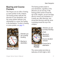
Basic Navigation according to the scale shown at the edge of the compass ring. The scale refers to the distance between dots on the course deviation indicator. The course line to your destination is based on your original starting point. Move back to the "course line to destination" to compensate for deviation and to get back on course. This is most useful if you are navigating on water or where there are no major obstacles in your path. It also helps you avoid hazards to either side of the course, such as shoals or submerged rocks. To change the Compass page data fields: 1. On the Compass page, touch a data field. 2. Touch a data type. 12 Oregon Series Owner's Manual
-
 1
1 -
2
-
3
-
4
-
5
-
6
-
7
-
8
-
9
-
10
-
11
-
12
-
13
-
14
-
 15
15 -
 16
16 -
 17
17 -
 18
18 -
 19
19 -
 20
20 -
 21
21 -
 22
22 -
 23
23 -
 24
24 -
 25
25 -
26
-
27
-
28
-
29
-
30
-
31
-
32
-
33
-
34
-
35
-
36
-
37
-
38
-
39
-
40
-
41
-
42
-
43
-
44
-
45
-
46
-
47
-
48
-
49
-
50
-
51
-
52
-
53
-
54
-
55
-
56
 |
 |

±²
Oregon Series Owner’s Manual
Basic Navigation
according to the scale shown at the
edge of the compass ring. The scale
refers to the distance between dots
on the course deviation indicator.
The course line to your destination is
based on your original starting point.
Move back to the “course line to
destination” to compensate for
deviation and to get back on course.
This is most useful if you are
navigating on water or where there
are no major obstacles in your path.
It also helps you avoid hazards to
either side of the course, such as
shoals or submerged rocks.
To change the Compass page
data fields:
1. On the Compass page, touch a
data field.
2. Touch a data type.