Garmin aera 795 Quick Reference Guide - Page 34
Flight Plan Waypoints, Nearest Airports, Recent, Waypoints, Show Raw Text/Show Decoded Text
 |
View all Garmin aera 795 manuals
Add to My Manuals
Save this manual to your list of manuals |
Page 34 highlights
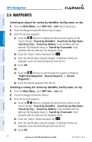
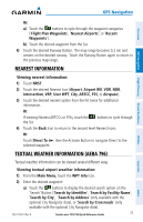
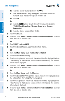
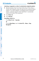
Overview GPS Navigation Hazard Avoidance Flight Planning GPS Navigation b) Touch the 'Search' Button (between the ). c) Enter the desired data using the keypad. If duplicate entries are displayed, touch the desired duplicate from the list. d) Touch OK. Or: a) Touch the buttons to cycle through the waypoint categories ('Flight Plan Waypoints', 'Nearest Airports', or 'Recent Waypoints'). b) Touch the desired waypoint from the list. 3) Touch the WX Tab. 4) If desired touch Menu > Show Raw Text/Show Decoded Text to switch from raw data to decoded data. Or: 1) Touch NRST > Airport WX. 2) Touch the desired Nearest Airport Weather from the list. Or: 1) From the Main Menu, touch the Weather > METAR. 2) Touch the desired METAR flag. 3) Touch the Map Feature Button with the desired identifier displayed (refer to 'Map Panning' in the Overview Section for more information). The weather information is displayed. 4) If desired touch Menu > Show Raw Text/Show Decoded Text to switch from raw data to decoded data. Or: 1) From the Main Menu, touch the Map Icon. 2) Touch the desired METAR Flag (If the METAR flags are not displayed, adjust the settings from the 'Set Up Map' menu option). 3) Touch the Map Feature Button with the desired identifier displayed (refer to 'Map Panning' in the Overview Section for more information). The weather information is displayed. 4) If desired touch Menu > Show Raw Text/Show Decoded Text to switch from raw data to decoded data. Utilities Appendix Index 24 Garmin aera 795/796 Quick Reference Guide 190-01194-01 Rev. B
-
 1
1 -
2
-
3
-
4
-
5
-
6
-
7
-
8
-
9
-
10
-
11
-
12
-
13
-
14
-
15
-
16
-
17
-
18
-
19
-
20
-
21
-
22
-
23
-
24
-
25
-
26
-
27
-
28
-
 29
29 -
 30
30 -
 31
31 -
 32
32 -
 33
33 -
 34
34 -
 35
35 -
 36
36 -
 37
37 -
 38
38 -
 39
39 -
40
-
41
-
42
-
43
-
44
-
45
-
46
-
47
-
48
-
49
-
50
-
51
-
52
-
53
-
54
-
55
-
56
-
57
-
58
-
59
-
60
-
61
-
62
 |
 |