Garmin dezl OTR700/800/1000 Owners Manual - Page 18
Live Services, Traffic, and, Smartphone Features
 |
View all Garmin dezl OTR700/800/1000 manuals
Add to My Manuals
Save this manual to your list of manuals |
Page 18 highlights
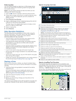
Restriction Warnings Height Weight Axle Weight Length Width No Trucks Allowed No Trailers Allowed No Hazardous Materials Allowed No Flammables Allowed No Water Pollutants Allowed No Left Turn No Right Turn No U Turn Road Condition Warnings Risk of grounding Lateral wind Narrow road Sharp curve Steep down hill Tree overhang Alerts Weigh station Road not verified for trucks Trip Information Viewing Trip Data from the Map From the map, select > Trip Data. Customizing the Trip Data Fields 1 From the map, select > Trip Data. 2 Select a trip data field. 3 Select an option. The new trip data field appears in the trip data map tool. Viewing the Trip Log Your device keeps a trip log, which is a record of the path you have traveled. 1 Select Settings > Map and Vehicle > Map Layers. 2 Select the Trip Log check box. Resetting Trip Information 1 From the map, select Speed. 2 Select a trip information data field. 3 Select > Reset Field(s). 4 Select an option: • When not navigating a route, select Select All to reset every data field except the speedometer, on the first page. • Select Reset Overall Data to reset Trip A and total data. • Select Reset Max. Speed to reset the maximum speed. • Select Reset Trip B to reset the odometer. Viewing Upcoming Traffic Before you can use this feature, your device must be receiving traffic data (Traffic, page 14). You can view traffic incidents coming up along your route or along the road on which you are traveling. 1 While navigating a route, select > Traffic. The nearest upcoming traffic incident appears in a panel on the right side of the map. 2 Select the traffic incident to view additional details. Viewing Traffic on the Map The traffic map shows color-coded traffic flow and delays on nearby roads. 1 From the main menu, select > dēzl > Traffic. 2 If necessary, select > Legend to view the legend for the traffic map. Searching for Traffic Incidents 1 From the main menu, select > dēzl > Traffic. 2 Select > Incidents. 3 Select an item in the list. 4 If there is more than one incident, use the arrows to view additional incidents. Customizing the Map Customizing the Map Layers You can customize which data appear on the map, such as icons for points of interest and road conditions. 1 Select Settings > Map and Vehicle > Map Layers. 2 Select the layers to include on the map, and select Save. Changing the Map Data Field 1 From the map, select a data field. NOTE: You cannot customize Speed. 2 Select a type of data to display. Changing the Map Perspective 1 Select Settings > Map and Vehicle > Driving Map View. 2 Select an option: • Select Track Up to display the map in two dimensions (2D), with your direction of travel at the top. • Select North Up to display the map in 2-D with north at the top. • Select 3-D to display the map in three dimensions. 3 Select Save. Live Services, Traffic, and Smartphone Features The Garmin Drive app allows your device to receive smart notifications and live information, such as live traffic data and weather information. Live traffic data: Sends real-time traffic data to your device, such as traffic incidents and delays, construction zones, and road closings (Traffic, page 14). Weather information: Sends real-time weather forecasts, road conditions, and weather radar to your device (Viewing the Weather Forecast, page 22). Smart Notifications: Displays phone notifications and messages on your device. This feature is not available for all languages. Hands-Free calling: Allows you to place and receive phone calls using your device, and allows you to use the device as a hands-free speaker phone. If the selected language supports the voice command feature, you can place calls using voice commands. Send locations to device: Allows you to send locations from your smartphone to your navigation device. Foursquare check in: Allows you to check in to Foursquare locations using your navigation device. 12 Live Services, Traffic, and Smartphone Features
-
 1
1 -
2
-
3
-
4
-
5
-
6
-
7
-
8
-
9
-
10
-
11
-
12
-
 13
13 -
 14
14 -
 15
15 -
 16
16 -
 17
17 -
 18
18 -
 19
19 -
 20
20 -
 21
21 -
 22
22 -
 23
23 -
24
-
25
-
26
-
27
-
28
-
29
-
30
-
31
-
32
-
33
-
34
-
35
-
36
 |
 |