Lowrance HDS-5 Gen2 StructureMap Guide - Page 3
must have Structurescan installed on your boat to use Live mode. - review
 |
View all Lowrance HDS-5 Gen2 manuals
Add to My Manuals
Save this manual to your list of manuals |
Page 3 highlights
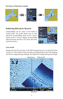
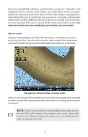
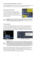
the history length that will show up behind the vessel icon. Typically it will display the last 4-5 minutes of recording. Live mode allows the user to quickly identify interesting areas of the lake and how they relate to vessel position. It also allows the user to scroll back and zoom in on a recently scanned areas of the lake to look at additional details of what was scanned. Live mode does not save any data. If the unit is turned off, all recent sonar history is lost. You must have Structurescan installed on your boat to use Live mode. Saved mode Displays StructureMap (.smf ) files that have been created from structure sonar log (.sl2) files. Saved mode is used to view a map of the underwater environment that can be reviewed and examined either on or off of the Navigating a StructureMap in saved mode water. It can be used when revisiting an area that has already been scanned in order to assist the user in positioning the vessel or locating specific points of interest. NOTE: If there is more than one StructureMap of the same area on the same SD card, the maps will overlap on your screen. If you want to have more than one map of the same area, you should put the maps on separate SD cards. 3
-
 1
1 -
 2
2 -
 3
3 -
 4
4 -
 5
5 -
 6
6 -
 7
7 -
 8
8
 |
 |
