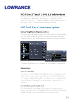
Lowrance HDS-9 Gen2 Touch HDS Gen2 Touch 2.5 software release addendum - EN - Page 2
Charting - software update
 |
View all Lowrance HDS-9 Gen2 Touch manuals
Add to My Manuals
Save this manual to your list of manuals |
Page 2 highlights
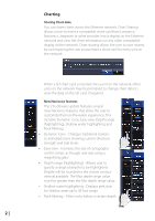
Charting Sharing Chart data You can share charts across the Ethernet network. Chart Sharing allows a user to insert a compatible chart card from Lowrance, Navionics, Jeppesen or other provider into a display on the Ethernet network and view the chart information on any other compatible display on the network. Chart sharing allows the user to save money by not requiring the user to purchase a chart card for every unit on the network. When a SD chart card is inserted into a unit on the network, other units on the network may be prompted to change chart data to view the data on the SD card, if required. New Navionics features The 2.0 software update features several new Navionics features that allow the user to customize their on-the-water experience. This includes Dynamic icons, Easy view, Depth range (highlighting), Shallow water highlighting and Rock filtering. • Dynamic Icons - Changes traditional stations to animated icons showing current direction, strength and tide levels • Easy view - Increases the size of cartography on the screen, as though user was using a magnifying glass • Depth range (highlighting) - Allows user to specify a range of depths to be highlighted. Depths will be rounded to the closest contour interval available. The Max depth range value must be greater than the Min depth range value. • Shallow water highlighting - Displays pink dots for Shallow areas up to 30 foot range. • Rock filtering - Filters rocks below a certain depth 2 |
-
 1
1 -
 2
2 -
 3
3 -
 4
4 -
 5
5 -
 6
6 -
 7
7 -
 8
8 -
9
-
10
-
11
-
12
-
13
-
14
-
15
-
16
 |
 |
