Motorola MOTOwi4 User Manual - Page 2
Outdoor Wireless Network Design Process - products
 |
View all Motorola MOTOwi4 manuals
Add to My Manuals
Save this manual to your list of manuals |
Page 2 highlights
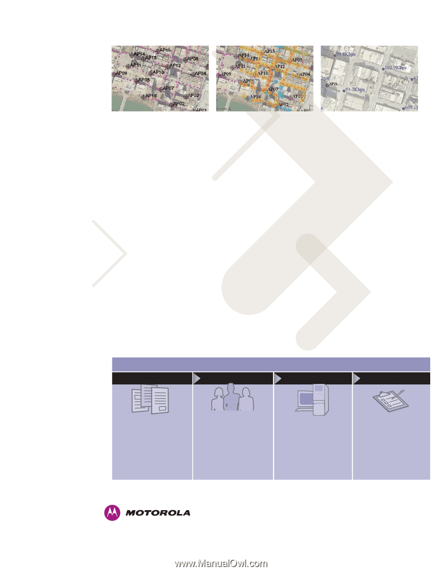
SPECIFICATION SHEET BroadbandScanner Software Motorola Wireless Broadband BroadbandScanner is part of the Motorola's comprehensive portfolio of wireless broadband solutions, applications and services. Designed to complement and complete wireless networks, Motorola Wireless Broadband solutions address a broad range of applications across municipal, enterprise, and operator segments. The comprehensive Motorola Wireless Broadband portfolio creates a true end-to-end ecosystem of complementary products, services and solutions that provide high speed connectivity enabling a broad range of applications in fixed, nomadic, portable or mobile environments. Working together, Motorola Mesh Wide Area Network solutions combined with other wireless broadband access technologies deliver ubiquitous, metro-wide (community-wide, campuswide) wireless broadband coverage. WHY MOTOROLA Motorola is uniquely positioned to meet customers' need for great agility through its wireless network solutions vision. Motorola has aligned its business units and roadmaps to provide a comprehensive, end-to-end solution covering all aspects of the broadband wireless access deployment. With our deep and extensive patent portfolio, over a decade of R&D investment, and our experience as a global supplier of broadband wireless access solutions, Motorola is primed to deliver its best in class wireless networks. Motorola is committed to leading the industry with Mesh Wide Area Networks solutions addressing the full scope of the operator's deployment needs including access, core, devices, network management and services. Measure and record live network activity Visualize the network coverage Display the throughput data rate When used with Motorola's SiteSpy software, BroadbandScanner's AP performance feature provides a unique capability to generate network traffic and assess real application-level throughput without the need for an active Internet backhaul connection. As a result, post-deployment teams can verify and troubleshoot AP link connectivity, packet latency, data throughput, and connections to the NOC (Network Operations Center) before connecting live to the outside world. GPS-Driven Accuracy Knowing precise locations during measurement is crucial for accurately validating mesh and point-tomultipoint network performance. Access to live GPS coordinates is the best way for a validation team to determine measurement locations. BroadbandScanner supports direct connection to industry-standard GPS receivers. When recording measurements with GPS enabled, the software updates latitude and longitude coordinates within the site map in real-time. BroadbandScanner is a key component in Motorola's Outdoor Wireless Network Design process, which details the various stages of the outdoor network project lifecycle (Fig. 1). BroadbandScanner is used in Phases two and four, while BroadbandPlanner, Motorola's comprehensive design and measurement solution, addresses all four phases. FEATURES AND BENEFITS • Directly import AutoCAD, GeoTIFF, DXF and SHP files • GPS support enables accurate measurement and AP location • Measure and visualize network RF characteristics to ensure contract performance goals • Maintain flexibility through a hardware independent, common software platform • Differentiate by guaranteeing superior network QoS, which enables bandwidth-intensive applications like VoWi-Fi and streaming media • Decrease the total cost of ownership (TCO) of mesh and point-to-multipoint networks by reducing costly field work and rework • Visualize critical QoS information such as RSSI (Received Signal Strength Intensity), SIR (Signal to Interference Ratio), SNR (Signal to Noise Ratio), and throughput data rate THE MOTOROLA ADVANTAGE An innovator of indoor and outdoor wireless communications technology, Motorola provides the network performance needed to boost productivity and increase operational efficiency across your business enterprise. Outdoor Wireless Network Design Process PHASE 1 PHASE 2 PHASE 3 PHASE 4 Requirements Gathering • Define geographic area to be served • Determine intended uses • Select equipment and backhaul • Acquire maps, terrain and building/foliage shapefiles Field Testing • Secure/Identify mounting locations • Test for interference • Perform trial area testing Figure 1: Outdoor Wireless Network Design Process Design • Import and merge geographic information • Place wireless hardware • Evaluate "what if" scenarios to determine optimal coverage, capacity, backhaul and mesh links Deployment/Verification • Deliver deployment plan • Install equipment • Adjust design based on site obstacles • Measure actual coverage and network throughput • Verify performance criteria are met Motorola, Inc. www.motorola.com/rfdesign The information presented herein is to the best of our knowledge true and accurate. No warranty or guarantee expressed or implied is made regarding the capacity, performance or suitability of any product. Product specifications subject to change without notice. SiteSpy, MEA, MeshConnex, MeshManager, SecureMesh, and Hop-by-Hop Security are trademarks or registered trademarks of Motorola, Inc. MOTOROLA and the Stylized M Logo are registered in the U.S. Patent and Trademark Office. All other product or service names are the property of their registered owners. © Motorola, Inc. 2009
-
 1
1 -
 2
2
 |
 |