Alpine INE-W967HD Navigation Owner s Manual english
Alpine INE-W967HD Manual
 |
View all Alpine INE-W967HD manuals
Add to My Manuals
Save this manual to your list of manuals |
Alpine INE-W967HD manual content summary:
- Alpine INE-W967HD | Navigation Owner s Manual english - Page 1
User Manual Alpine Navigation System Navigation software for the Alpine Navigation System English March 2015, ver. 1.0 - Alpine INE-W967HD | Navigation Owner s Manual english - Page 2
preview and next street...17 2.3.5 Maneuver icons...17 2.3.6 Lane information and signposts ...18 2.3.7 Junction view ...19 2.3.8 Tunnel view ...19 2.3.9 Freeway services...20 2.3.10 3D object types ...20 2.3.11 Traffic events ...21 2.4 Navigation menu...21 3 Using the navigation...24 3.1 Selecting - Alpine INE-W967HD | Navigation Owner s Manual english - Page 3
navigation ...57 3.8.2 Selecting the destination in off-road mode 57 3.8.3 Navigating in off-road mode...58 3.9 Updating the navigation software and the maps 58 4 Reference guide ...60 4.1 Concepts ...60 4.1.1 2D/3D GPS reception ...60 4.1.2 Natural and TTS voices...60 4.1.3 Road safety cameras - Alpine INE-W967HD | Navigation Owner s Manual english - Page 4
4.1.9.4 Hints upon detour ...65 4.2 Information menu ...66 4.2.1 Where Am I ...67 4.2.2 Trip Monitor ...68 4.3 Setup menu...68 4.3.1 Route preferences...70 4.3.1.1 Vehicle profile...70 4.3.1.2 Route Planning Method types ...72 4.3.1.3 Navigation Mode ...72 4.3.1.4 Road types...72 4.3.2 Sound ...73 - Alpine INE-W967HD | Navigation Owner s Manual english - Page 5
you are the driver of the vehicle, we recommend that you plan and review your route before you start your journey. Plan the route before your departure deviate from the planned route, Alpine Navigation System changes the instructions accordingly. For more information, see the end-user license agreement - Alpine INE-W967HD | Navigation Owner s Manual english - Page 6
to keep the navigation system up-to-date. Go to alpine.naviextras.com to find map updates and extra content for your navigation system. Use the Toolbox data. To update your navigation software and its maps, you need a PC with Internet access and a USB storage device. For instructions, see:Page 58 - Alpine INE-W967HD | Navigation Owner s Manual english - Page 7
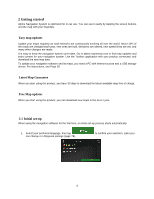
2. Read the end-user license agreement, and tap use. if you agree with the terms of 3. The Configuration Wizard starts. Tap to continue. 4. Select the language and speaker used for voice guidance messages. Later you can change it in Regional settings (page 73). Tap to continue. 5. If needed, - Alpine INE-W967HD | Navigation Owner s Manual english - Page 8
is now complete, tap . 8. A warning appears to draw your attention to the hazards of operating, entering data into or obtaining data from the Alpine Navigation System during driving or transportsation. After reading it carefully, tap to enter the navigation view. This warning pops up every time - Alpine INE-W967HD | Navigation Owner s Manual english - Page 9
Alpine Navigation System saves your selections and applies the new settings without confirmation as soon as you use the controls. 2.2.2 Using the cursor You can select a - Alpine INE-W967HD | Navigation Owner s Manual english - Page 10
Finalizing the keyboard entry Tap . Hiding the keyboard Tap . 2.2.4 Using touch gestures You usually need to tap the screen only once. However, some useful features can be accessed with other gestures. See the table below. Action Function Tapping and holding the screen Tap and keep pressing - Alpine INE-W967HD | Navigation Owner s Manual english - Page 11
finger towards the direction you want to move the map. Zooming in and out , Change how much of the map is displayed on the screen. Alpine Navigation System uses maps that let you examine the locations at various zoom levels, always with optimized content. It always displays street names and other - Alpine INE-W967HD | Navigation Owner s Manual english - Page 12
Changing 2D, 3D, or 2D North up views Checking the compass Selecting additional options Selecting a destination , , Switch between the 3D perspective, 2D Heading up, and 2D North up map view modes. In Heading up mode the map is rotated so its top always points in the current driving direction. - Alpine INE-W967HD | Navigation Owner s Manual english - Page 13
2.3 Navigation view The navigation view is the main screen of Alpine Navigation System that shows the planned route on a map. Alpine Navigation System works with digital maps which are not simply the computerized versions of traditional paper maps. Similarly to paper road maps, the 2D mode - Alpine INE-W967HD | Navigation Owner s Manual english - Page 14
faces North. 8 Traffic It shows traffic-related information. See page 44. 9 Zoom You can change how much of the map is displayed on the screen. Alpine Navigation System uses maps that let you zoom in and out on the map. See Page 11. 10 Lane On multi-lane roads, it shows - Alpine INE-W967HD | Navigation Owner s Manual english - Page 15
suspend the navigation. 18 Additional It shows the Freeway services, Parking around destination, or the information Destination menu replaced with a generic tunnel image. See page 19. 2.3.1 Streets and roads Alpine Navigation System shows the streets similarly to paper road maps. Their width and - Alpine INE-W967HD | Navigation Owner s Manual english - Page 16
and roads that are affected by traffic events You can choose whether you want to use or avoid certain road types (page 70). However, when Alpine Navigation System cannot avoid such roads, the route includes them and shows them in a color that is different from the route color. Road segments may - Alpine INE-W967HD | Navigation Owner s Manual english - Page 17
2.3.4 Turn preview and next street When navigating a route, the top section of the Navigation view shows information about the next route event (maneuver) and the next street or the next town. There is a field in the top left corner displaying the next maneuver. Both the type of the maneuver (turn, - Alpine INE-W967HD | Navigation Owner s Manual english - Page 18
it is important to take the appropriate lane in order to follow the planned route. If lane information is available in the map data, Alpine Navigation System displays the lanes and their directions using small arrows at the bottom of the map. Highlighted arrows represent the lanes and the direction - Alpine INE-W967HD | Navigation Owner s Manual english - Page 19
2.3.7 Junction view If you are approaching a freeway exit or a complex intersection and the needed information exists, the map is replaced with a 3D view of the junction. The lanes you need to take are displayed with arrows. At the top of the screen, road signs show you additional information. If - Alpine INE-W967HD | Navigation Owner s Manual english - Page 20
as a waypoint to your route if necessary. If you want to display other types of Places at the next few service stations, you can change the icons in . See page 76. 2.3.10 3D object types Alpine Navigation System supports the following 3D object types: Type 3D terrain Elevated roads Description - Alpine INE-W967HD | Navigation Owner s Manual english - Page 21
2.3.11 Traffic events Road segments affected by traffic events are displayed in a different color on the map. The following icons may appear at the top right corner of the screen: Button Description It is displayed when traffic events are not received. It is displayed when traffic events are - Alpine INE-W967HD | Navigation Owner s Manual english - Page 22
You can see the following menu options when you are navigating without a planned route: Button Function Select your destination by entering an address or its coordinate, or by selecting a Place, a Saved Location, or a Saved Route. You can also look up your recent destinations from the History. - Alpine INE-W967HD | Navigation Owner s Manual english - Page 23
The More button appears on the screen to display additional features. Tap it to open the list of additional features on certain screens. Tap the Back button to return to the previous screen. You can also press and hold this button to quickly return to the Navigation view from any other screen. 23 - Alpine INE-W967HD | Navigation Owner s Manual english - Page 24
3 Using the navigation By default, Alpine Navigation System calculates routes using the road network of can add as many destinations to your route as you like. See Page 42. You can also use Alpine Navigation System for off-road navigation. See page 57. The following sections describe how to select a - Alpine INE-W967HD | Navigation Owner s Manual english - Page 25
2. Tap . You can see the input field at the top of the screen. Right next to it you can see the search area, the town around which the search is carried out. The default search area is the area where you are located. For a local search, skip the next step. 3. (optional) To search in a different - Alpine INE-W967HD | Navigation Owner s Manual english - Page 26
Tap to see the list of recent destinations with a matching name or address. Tap to see the list of your saved locations with a matching name. Tap to see the list of matching addresses. Tap to see the list of matching Place category names. Scroll the list and select one of the - Alpine INE-W967HD | Navigation Owner s Manual english - Page 27
steps: 1. Press the navigation hardkey button to access the Navigation menu. 2. Tap . 3. Select the country by performing the following steps: a. By default, the Alpine Navigation System proposes the country where you are or in case there is no valid GPS position, the country of the last known - Alpine INE-W967HD | Navigation Owner s Manual english - Page 28
b. To open the list, tap , and select the town or ZIP code. 2. Enter the street name and the house number or crossing street by performing the following steps: a. Start entering the street name on the keyboard. The names that match the string appear in a list. b. Tap to open the list of results. - Alpine INE-W967HD | Navigation Owner s Manual english - Page 29
3.1.2.2 Selecting a town center The town center is not the geometric center of the town but an arbitrary point the map creators have chosen. In towns and villages, it is usually the most important intersection and in larger towns, it is one of the important intersections. 1. Press the navigation - Alpine INE-W967HD | Navigation Owner s Manual english - Page 30
5. Instead of entering the house number, tap selected as the destination. . The midpoint of the street is 3.1.2.4 Selecting an intersection in a town To navigate to an intersection, perform the following steps: 1. Press the navigation hardkey button to access the Navigation menu. 2. Go to and - Alpine INE-W967HD | Navigation Owner s Manual english - Page 31
2. Tap 3. Tap 4. Tap . to open the numeric keypad and start entering the ZIP code. to open the list of results. Select the ZIP code from the list. 5. Continue the search as described previously (page 27). 3.1.3 Selecting a Place of Interest You can search for Places of Interest (Places) in the - Alpine INE-W967HD | Navigation Owner s Manual english - Page 32
3.1.3.1 Using Quick search categories The Quick search feature helps you quickly find the most frequently selected types of Places. Perform the following steps: 1. Press the navigation hardkey button to access the Navigation menu. 2. Tap . The following Quick search categories appear: route. - Alpine INE-W967HD | Navigation Owner s Manual english - Page 33
. To filter the list of results by providers, tap on the right side of the screen. and then the provider logo 5. (optional) If needed, tap to further filter the list of results. 6. Browse the list and tap one of the list items. 7. The route is calculated and the map appears showing the entire - Alpine INE-W967HD | Navigation Owner s Manual english - Page 34
Tap to search for a place within a selected town. (The result list is ordered by the distance from the center of the selected town.) 4. (optional) If you have selected , select the town to search in. 5. Select one of the main Place categories (for example, Accommodation), then browse the - Alpine INE-W967HD | Navigation Owner s Manual english - Page 35
Tap to reorder the list. To filter the list of results by providers, tap screen. and then the provider logo on the right side of the 8. Browse the list and tap one of the list items. A full screen map appears with the selected point in the middle. 9. The process continues the same way as in - Alpine INE-W967HD | Navigation Owner s Manual english - Page 36
4. (optional) If you have selected , select the town to search in. You can search for the name of a Place in all categories by performing the following steps: 1. Tap the categories. . Using the keyboard, start entering the name of the Place or browse in 2. After entering a few letters, tap to - Alpine INE-W967HD | Navigation Owner s Manual english - Page 37
current position (or around the last known position if the current position is not available): : Car repair and roadside assistance services : Medical and emergency services : Police stations : Gas stations 3. Tap any of the quick search buttons to get an instant list of those types - Alpine INE-W967HD | Navigation Owner s Manual english - Page 38
3.1.4 Selecting a Saved Location To select a location that you have already saved (page 53), perform the following steps: 1. Press the navigation hardkey button to access the Navigation menu. 2. Tap . 3. The list of Saved Locations is displayed. It contains two pre-set categories: Home and Work. - Alpine INE-W967HD | Navigation Owner s Manual english - Page 39
3.1.5 Selecting a History item The destinations that you have used earlier appear in the History list. Smart History offers these locations from your previous destinations, using parameters like the current time of day, the day of week, and the current location. The more you use the navigation - Alpine INE-W967HD | Navigation Owner s Manual english - Page 40
3.1.6 Entering coordinates To select a destination by entering its coordinates, perform the following steps: 1. Press the navigation hardkey button to access the Navigation menu. 2. Tap . 3. You can enter the latitude and longitude values in any of the following formats: decimal degrees, degrees - Alpine INE-W967HD | Navigation Owner s Manual english - Page 41
3.1.7 Selecting a location on the map To select a map location, perform the following steps: 1. Locate your destination on the map. Move and scale the map as necessary. 2. Tap the location that you want to select as your destination. The cursor ( ) appears there. 3. (optional) If needed, tap this - Alpine INE-W967HD | Navigation Owner s Manual english - Page 42
3.1.8 Planning a Multipoint Route To build your route destination-by-destination, perform the following steps: 1. Press the navigation hardkey button to access the Navigation menu. 2. Tap . 3. There is only one line in the list of route points, the starting point of the route, which is normally - Alpine INE-W967HD | Navigation Owner s Manual english - Page 43
8. (optional) Tap also delete all the destinations. to optimize the whole route or the order of waypoints. You can 9. When you have added all the route points, tap automatically calculated. and the planned route is 3.2 Checking Route Information and Alternatives To get a map overview of the - Alpine INE-W967HD | Navigation Owner s Manual english - Page 44
Tap to list route alternatives and select the most suitable route for you. Tap on the Route Summary screen to carry out additional actions, for example edit your route preferences or display the itinerary. 3.3 Checking Traffic Events Offline statistical traffic information (historical speed - Alpine INE-W967HD | Navigation Owner s Manual english - Page 45
2. If there is at least one significant event on the planned route, a description is displayed about the next event. Tap to see the list of all events. 3. Tap any of the list items to see its details and to display the affected road segment in its full length on the map. To display real-time - Alpine INE-W967HD | Navigation Owner s Manual english - Page 46
Tap to display historical traffic information. A 2D map is displayed with road segments colored by the likely density of the traffic in the given period. The information relevant for the current period is shown when you open the screen. If necessary, you can browse the map for a better view of - Alpine INE-W967HD | Navigation Owner s Manual english - Page 47
3.4.1 Setting a new starting point For normal navigation, all routes are calculated from the current position. You can pause navigation to check future routes, simulate them or see their length in time and distance. Then you can set the starting point of the route to a location other than the - Alpine INE-W967HD | Navigation Owner s Manual english - Page 48
6. Tap to continue. The map returns with a transparent position marker (showing that there is no GPS reception). If a planned route already exists, it is now recalculated starting from the selected location. 7. To return to normal navigation, tap . 3.4.2 Adding an additional destination If you - Alpine INE-W967HD | Navigation Owner s Manual english - Page 49
3.4.3 Modifying the list of destinations To edit your route, perform the following steps: 1. Press the navigation hardkey button to access the Navigation menu. 2. In the Navigation menu, tap . You have the following options on this screen: Tap route. to delete all the destinations, or - Alpine INE-W967HD | Navigation Owner s Manual english - Page 50
in a name and tap . 4. The route is saved and it is available in in the Navigation menu. By selecting a previously saved route, Alpine Navigation System recalculates the route using the saved destination and/or the waypoints. 3.4.5 Deleting the planned route You have the following two options - Alpine INE-W967HD | Navigation Owner s Manual english - Page 51
suggestions, tap with different route planning methods. and scroll down for other alternative routes 5. Select one of the route alternatives and tap Alpine Navigation System recalculates the route. Tap The orange line now shows the new planned route. to return to the previous screen. to start - Alpine INE-W967HD | Navigation Owner s Manual english - Page 52
than a few suggestions, you can tap routes. and scroll down for 5. Select one of the route alternatives and tap to return to the previous screen. Alpine Navigation System replaces the original route. Tap journey. The orange line now shows the new planned route. to start your 52 - Alpine INE-W967HD | Navigation Owner s Manual english - Page 53
3.5 Saving a location To add any location to the saved locations (the list of frequently used destinations), perform the following steps: 1. Select a destination as described before. It can be an address, a Place, any location on the map, a previously used destination from History, and so on. 2. - Alpine INE-W967HD | Navigation Owner s Manual english - Page 54
3.5.1 Editing a Saved Location To edit a location that you have already added as a Saved Location, perform the following steps: 1. Press the navigation hardkey button, and tap . 2. The list of Saved Locations is displayed. 3. Tap and . 4. Tap the location you want to edit, tap and enter the - Alpine INE-W967HD | Navigation Owner s Manual english - Page 55
The warning for road safety cameras is disabled when you are in a country where road safety camera warning is prohibited. However, you must make sure that using this feature is Note! legal in the country where you intend to use it. 1. Return to the Navigation view, and select the Alert Point. The - Alpine INE-W967HD | Navigation Owner s Manual english - Page 56
3.7 Running a Simulation To run a simulated navigation that demonstrates the planned route, perform the following steps: 1. Press the navigation hardkey button to access the Navigation menu. 2. In the Navigation menu, tap . 3. Tap . 4. Tap . The simulation starts from the starting point of the - Alpine INE-W967HD | Navigation Owner s Manual english - Page 57
to 4, 8 or 16 times faster. Tap again to return to normal speed. 5. Tap to stop the simulation. 3.8 Off-road navigation When first started, Alpine Navigation System calculates routes using the road network of the maps provided with the product. If you want to disregard roads during navigation - Alpine INE-W967HD | Navigation Owner s Manual english - Page 58
Windows XP Service Pack 2 or later) Internet connection USB port An empty USB storage device with a capacity of at least 2 GB To update your navigation software and its maps, perform the following steps: 1. Download and install the Toolbox PC tool on your PC. a. Go to the alpine.naviextras.com - Alpine INE-W967HD | Navigation Owner s Manual english - Page 59
name and password. c. Use the Toolbox PC tool to download updates and to purchase additional extras at your convenience. For instructions on using the Toolbox, see the Toolbox How-to Guides at alpine.naviextras.com/shop/portal/support. d. Once the download is complete, remove the USB storage device - Alpine INE-W967HD | Navigation Owner s Manual english - Page 60
4 Reference guide The following sections describe the different concepts and menu screens of Alpine Navigation System. 4.1 Concepts 4.1.2 Natural and TTS voices Natural voices are the traditional type of voice instructions. Every phrase that occurs in voice guidance messages is recorded in a studio - Alpine INE-W967HD | Navigation Owner s Manual english - Page 61
Navigation System automatically recalculates the route if you deviate from the proposed itinerary. If traffic services are enabled, Alpine Navigation System considers real-time dynamic traffic information in route calculation and may also recalculate the route if the traffic situation changes during - Alpine INE-W967HD | Navigation Owner s Manual english - Page 62
slowly and zooms out when you drive at a high speed. 4.1.6 Speed limit warning Maps may contain information about the speed limits of the road segments. Alpine Navigation System is able to warn you if you exceed the current limit. This information may not be available for your region, or may not - Alpine INE-W967HD | Navigation Owner s Manual english - Page 63
on traffic icons, see page 21. To fine-tune this service, you have the following options in Traffic settings (page 80): Set the minimum amount of time that you think is worth saving at the cost of a detour. Instruct Alpine Navigation System to have you confirm the new planned route before - Alpine INE-W967HD | Navigation Owner s Manual english - Page 64
increase or decrease the distance to avoid on the highway. You can accept the recommended detour by tapping . 4.1.9.2 Real-time alternative routes Alpine Navigation System may offer an alternative route on normal roads in case of a traffic jam. The possible alternative route window appears and - Alpine INE-W967HD | Navigation Owner s Manual english - Page 65
available at your current position, you can receive realtime data on the occupancy of some parking facilities. If the online parking service is not available, Alpine Navigation System is searching for parking places in the Places of Interest. 4.1.9.4 Hints upon detour If you leave the planned route - Alpine INE-W967HD | Navigation Owner s Manual english - Page 66
. You need an Internet connection via your cell phone to access online services, like parking and weather information. Button Description Shows information on the current information. Shows the version of Alpine Navigation System, licenses, content, demo routes, credits, statistics, and the SWID. - Alpine INE-W967HD | Navigation Owner s Manual english - Page 67
4.2.1 Where Am I This screen contains information about the current position (or about the last known position if GPS reception is not available). You can access it the following two ways: By going to the Navigation menu and tapping and . By tapping the current street name if it is displayed - Alpine INE-W967HD | Navigation Owner s Manual english - Page 68
enable saving the trip logs automatically or you can save the trip logs manually. See page 81. By tapping your recorded trip on the Trip Monitor You can configure the navigation settings, and modify the behavior of Alpine Navigation System, by pressing the navigation hardkey button, and tapping . - Alpine INE-W967HD | Navigation Owner s Manual english - Page 69
The Setup menu provides the following options: Button Function Select the type of vehicle you are driving, the road types used in route planning, and the route planning method. Adjust the different sound volumes. Enable and set up warnings for speed limit, Alert Points (such as speed cameras), - Alpine INE-W967HD | Navigation Owner s Manual english - Page 70
4.3.1 Route preferences The following settings determine how routes are calculated: Button Function Set the type of vehicle you want to use to navigate the route. Based on this setting, some of the road types can be excluded from the route, or some of the restrictions may not be taken into - Alpine INE-W967HD | Navigation Owner s Manual english - Page 71
Maneuver restrictions and one-way streets are taken into account when planning a route. Roads are used only if access for taxis is allowed. Private roads, resident-only roads and walkways are excluded from routes. Maneuver restrictions and one-way streets are taken into account when planning a route - Alpine INE-W967HD | Navigation Owner s Manual english - Page 72
, the best selection for fast and normal cars. Results in a route with fewer turns and no difficult maneuvers. With this option, you can make Alpine Navigation System take, for example, the freeway instead of a series of smaller roads or streets. Gives a short route to minimize the travel distance - Alpine INE-W967HD | Navigation Owner s Manual english - Page 73
of very poor condition. They can only be driven by 4WD vehicles. Alpine Navigation System excludes 4WD tracks by default. 4.3.2 Sound You can modify or mute them. Adjust the volume of the guidance sounds (verbal instructions) or mute it. Adjust the volume of the non-verbal alert sounds ( - Alpine INE-W967HD | Navigation Owner s Manual english - Page 74
volume of the related sound. Mute the related sound. The slider becomes inactive. Tap again to re-enable it. Button Function Disable verbal instructions. This function is enabled by default. Choose from the following options: Announce the street names in the native language area of the selected - Alpine INE-W967HD | Navigation Owner s Manual english - Page 75
You can enable and modify the following settings: Button Description Alpine Navigation System is able to warn you if you exceed the . The maximum speed set in the vehicle profile is also used for this warning. Alpine Navigation System alerts you if you exceed the pre-set value even if the legal - Alpine INE-W967HD | Navigation Owner s Manual english - Page 76
Tap it to receive a warning when approaching a road safety camera or other Alert Points like school zones or railroad crossings. You must make sure that using this feature is legal in the country where you intend to use it. You can set the warning type for the different Alert Point categories (alert - Alpine INE-W967HD | Navigation Owner s Manual english - Page 77
, an orange line is displayed on the side of the screen, and a blue arrow on it shows your progress. Turn it on to get freeway service information (for example gas stations, restaurants) or turn it off if you do not need it. Select the - Alpine INE-W967HD | Navigation Owner s Manual english - Page 78
and the remaining distance are also displayed. In certain situations, Alpine Navigation System offers a detour when there is a traffic jam on a highway. your destination. See page 65. In certain situations, Alpine Navigation System offers different route alternatives when you leave the - Alpine INE-W967HD | Navigation Owner s Manual english - Page 79
levels of service: read out complex instructions, street names used. Alpine Navigation System may not support all the listed units in some voice guidance languages. By default, the time zone is taken from the map information and adjusted by your current location. Here you can manually - Alpine INE-W967HD | Navigation Owner s Manual english - Page 80
(not counting the traffic jam). If you set the Offer detour feature to 10 minutes, Alpine Navigation System recalculates the route because it saves 15 minutes, which is more than the 10 minutes traffic events. Enable or disable the manual confirmation of every recalculation due to traffic events. 80 - Alpine INE-W967HD | Navigation Owner s Manual english - Page 81
This line shows the current size of the trip database, the sum of all trip and track logs saved. 4.3.9 User Profiles If more drivers use Alpine Navigation Systemfor navigating, their settings can be remembered by using one of the user profiles. You can create a new profile by tapping enter a name - Alpine INE-W967HD | Navigation Owner s Manual english - Page 82
installed on the Device, including the core engine, other software modules and the graphical user interface, capable of processing and/or displaying the Databases and the Services. The term Software shall by definition include any modifications, updates, upgrades thereto. "Service supporting" - Alpine INE-W967HD | Navigation Owner s Manual english - Page 83
shall be deemed parts of the Navigation Product. 4.3 Error corrections, updates or upgrades or any other modifications to the Navigation Product used by third parties no longer permit us to make their Databases or Services available, or external issues arise that make it imprudent or impractical - Alpine INE-W967HD | Navigation Owner s Manual english - Page 84
sold to another User without selling the Device itself. 6.3 The Databases and Services provided to the User may only be used together with User's copy of in part), to separate it into parts, combine it with other products, install it in other products, utilize it in other products, not even for the - Alpine INE-W967HD | Navigation Owner s Manual english - Page 85
whereby the Navigation Product obtained by the User should be completely error-free. 8.2 THE LICENSED NAVIGATION PRODUCT, INCLUDING ANY OF THE DATABASES, OR SERVICES FORMING PART THEREOF ARE PROVIDED ON AN "AS IS" AND "WITH ALL FAULTS BASIS" (INCLUDING NO WARRANTY FOR THE CORRECTION OF FAULTS) AND - Alpine INE-W967HD | Navigation Owner s Manual english - Page 86
be used to encourage, facilitate or support the violation of any laws. ii) that the Database or information obtained through the Services provided by third parties may only be used at the the Device or may be deleted by the User manually. 10.3 Collected data is transmitted, stored and handled - Alpine INE-W967HD | Navigation Owner s Manual english - Page 87
or technical circumstances; or (iv) When it becomes no longer possible to provide the Service due dto a System failure, etc. 11.4 User acknowledges that the data or information provided through Connected Services is not updated in real-time and may not accurately reflect the real life situation or - Alpine INE-W967HD | Navigation Owner s Manual english - Page 88
12. Third party supplier terms 12.1 Third parties supply Services or Database built into the Navigation Product and such third party including but not limited to the selection of potential locations for the installation of speed cameras, speed traps or other speed tracking devices. Traffic data - Alpine INE-W967HD | Navigation Owner s Manual english - Page 89
contained herein are subject to change without prior notification. This manual may not, in whole or in part, be reproduced or including photocopying and recording, without the express written consent of Alpine Electronics, Inc. © 2015 - Alpine Electronics, Inc. All rights reserved. © 2015 - NNG
-
 1
1 -
 2
2 -
 3
3 -
 4
4 -
 5
5 -
 6
6 -
 7
7 -
8
-
9
-
10
-
11
-
12
-
13
-
14
-
15
-
16
-
17
-
18
-
19
-
20
-
21
-
22
-
23
-
24
-
25
-
26
-
27
-
28
-
29
-
30
-
31
-
32
-
33
-
34
-
35
-
36
-
37
-
38
-
39
-
40
-
41
-
42
-
43
-
44
-
45
-
46
-
47
-
48
-
49
-
50
-
51
-
52
-
53
-
54
-
55
-
56
-
57
-
58
-
59
-
60
-
61
-
62
-
63
-
64
-
65
-
66
-
67
-
68
-
69
-
70
-
71
-
72
-
73
-
74
-
75
-
76
-
77
-
78
-
79
-
80
-
81
-
82
-
83
-
84
-
85
-
86
-
87
-
88
-
89
 |
 |

User Manual
Alpine Navigation System
Navigation software for the Alpine Navigation System
English
March 2015, ver. 1.0